File:Map Crusader states 1135-fr2.svg
Jump to navigation
Jump to search

Size of this PNG preview of this SVG file: 484 × 599 pixels. Other resolutions: 194 × 240 pixels | 388 × 480 pixels | 620 × 768 pixels | 827 × 1,024 pixels | 1,654 × 2,048 pixels | 744 × 921 pixels.
Original file (SVG file, nominally 744 × 921 pixels, file size: 888 KB)
Captions
Captions
Add a one-line explanation of what this file represents
Summary
[edit]| Description |
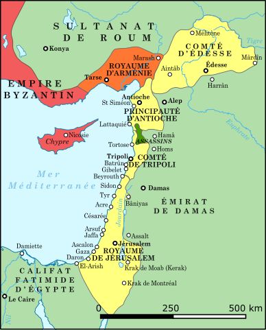
Français : Les États latins d'Orient en 1135 |
| Date | |
| Source | File:Asia minor 1140-es.svg et File:Asia minor 1140.jpg |
| Author | IvanBondarev |
| Other versions |
[]
See also[edit] |


-ka.png)


Licensing
[edit]
I, the copyright holder of this work, hereby publish it under the following license:
This file is licensed under the Creative Commons Attribution-Share Alike 4.0 International license.
- You are free:
- to share – to copy, distribute and transmit the work
- to remix – to adapt the work
- Under the following conditions:
- attribution – You must give appropriate credit, provide a link to the license, and indicate if changes were made. You may do so in any reasonable manner, but not in any way that suggests the licensor endorses you or your use.
- share alike – If you remix, transform, or build upon the material, you must distribute your contributions under the same or compatible license as the original.
File history
Click on a date/time to view the file as it appeared at that time.
| Date/Time | Thumbnail | Dimensions | User | Comment | |
|---|---|---|---|---|---|
| current | 14:29, 14 March 2024 | | 744 × 921 (888 KB) | IvanBondarev (talk | contribs) | Couleurs |
| 07:23, 7 July 2023 |  | 744 × 921 (888 KB) | IvanBondarev (talk | contribs) | Détails | |
| 06:10, 5 June 2023 |  | 744 × 921 (886 KB) | IvanBondarev (talk | contribs) | Corrections | |
| 19:05, 4 June 2023 |  | 780 × 921 (886 KB) | IvanBondarev (talk | contribs) | Format | |
| 18:48, 4 June 2023 |  | 1,010 × 886 (886 KB) | IvanBondarev (talk | contribs) | Corrections | |
| 18:14, 4 June 2023 |  | 1,010 × 886 (490 KB) | IvanBondarev (talk | contribs) | Uploaded own work with UploadWizard |
You cannot overwrite this file.
File usage on Commons
The following 33 pages use this file:
- User:IvanBondarev
- User:Magog the Ogre/Multilingual legend/2023 July 1-10
- User:Magog the Ogre/Multilingual legend/2023 June 1-10
- User:Magog the Ogre/Multilingual legend/2024 March 13-16
- File:Crusader States (1135)-ka.png
- File:Lähis-Ida 1135.png
- File:Map Crusader states 1135-ar.png
- File:Map Crusader states 1135-cs.svg
- File:Map Crusader states 1135-de.svg
- File:Map Crusader states 1135-de2.svg
- File:Map Crusader states 1135-el.svg
- File:Map Crusader states 1135-en.svg
- File:Map Crusader states 1135-eo.svg
- File:Map Crusader states 1135-es.svg
- File:Map Crusader states 1135-es2.svg
- File:Map Crusader states 1135-fr.svg
- File:Map Crusader states 1135-fr2.svg
- File:Map Crusader states 1135-hu.svg
- File:Map Crusader states 1135-hy.svg
- File:Map Crusader states 1135-it.png
- File:Map Crusader states 1135-jp.png
- File:Map Crusader states 1135-mk.svg
- File:Map Crusader states 1135-nl.svg
- File:Map Crusader states 1135-pl.png
- File:Map Crusader states 1135-pl.svg
- File:Map Crusader states 1135-pt.svg
- File:Map Crusader states 1135-ru.svg
- File:Map Crusader states 1135-zh.svg
- File:Map Crusads states 1135-fa.png
- File:The Crusader States in 1135-ar.svg
- File:The Crusader States in 1135.svg
- Template:Other versions/Map Crusader states 1135
- Category:Lordship of Sidon
File usage on other wikis
The following other wikis use this file:
- Usage on es.wikipedia.org
- Usage on fr.wikipedia.org
- Usage on ru.wikipedia.org
- Usage on uk.wikipedia.org
- Usage on www.wikidata.org
Metadata
Categories:
- Maps showing 12th-century history
- Maps of the history of the Middle East
- Maps of the crusades
- Maps of the Kingdom of Jerusalem
- Maps of the County of Tripoli
- Maps of the Principality of Antioch
- Maps of Cilicia
- Maps of the County of Edessa
- Maps of the history of Cyprus
- Maps of the history of the Levant
- French-language SVG maps showing history
- Maps of the Byzantine Empire in the 12th century