File:Louisiana - Poverty Point - Karte.png

Original file (1,178 × 1,719 pixels, file size: 1.01 MB, MIME type: image/png)
Captions
Captions
| DescriptionLouisiana - Poverty Point - Karte.png |
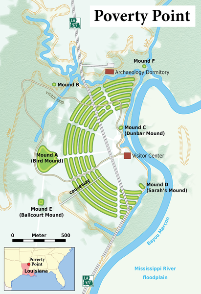
Deutsch: Karte: Übersicht über die archäologische Stätte von Poverty Point (Louisiana)
English: Map of the Poverty Point archaeological site |
|||||
| Date | ||||||
| Source |
Self made, using the following files: The map contents are based on the follwowing informations:
Many thanks to h-stt who provided me with all these links!
|
|||||
| Author | Maximilian Dörrbecker (Chumwa) | |||||
| Permission (Reusing this file) |
I, the copyright holder of this work, hereby publish it under the following license: This file is licensed under the Creative Commons Attribution-Share Alike 2.5 Generic license.
Sie dürfen das Bild zu den folgenden Bedingungen nutzen:
|
|||||
| Other versions |
|
File history
Click on a date/time to view the file as it appeared at that time.
| Date/Time | Thumbnail | Dimensions | User | Comment | |
|---|---|---|---|---|---|
| current | 08:20, 30 December 2016 |  | 1,178 × 1,719 (1.01 MB) | Chumwa (talk | contribs) | |
| 15:27, 23 December 2016 |  | 1,178 × 1,719 (1.01 MB) | Chumwa (talk | contribs) | neu entdeckten Mound E hinzugefügt | |
| 17:44, 13 April 2008 |  | 1,178 × 1,719 (769 KB) | Chumwa (talk | contribs) | Bayou Maçon -> Bayou Marçon | |
| 16:21, 13 April 2008 |  | 1,178 × 1,719 (767 KB) | Chumwa (talk | contribs) | Text war zu lang... | |
| 16:08, 13 April 2008 |  | 1,178 × 1,719 (767 KB) | Chumwa (talk | contribs) | Anmerkungen von h-stt eingearbeitet (Mould statt Erdhügel, Ballcourt Mould kleiner). | |
| 07:14, 13 April 2008 |  | 1,178 × 1,719 (770 KB) | Chumwa (talk | contribs) | Korrektur am Weg zum Besucherzentrum | |
| 07:08, 13 April 2008 |  | 1,178 × 1,719 (773 KB) | Chumwa (talk | contribs) | Darstellung des Damms ngeändert und Parkplatz hinzugefügt | |
| 05:42, 13 April 2008 |  | 1,178 × 1,719 (760 KB) | Chumwa (talk | contribs) | Bewaldung hinzugefügt | |
| 23:14, 12 April 2008 |  | 1,178 × 1,719 (591 KB) | Chumwa (talk | contribs) | {{Information |Description= *{{ de }} Karte: Übersicht über die archäologische Stätte von Poverty Point (Louisiana) |Source=Self made, using the files: * orientation map * Louisiana highway sign {{Kartenwü |
You cannot overwrite this file.
File usage on Commons
The following 5 pages use this file:
File usage on other wikis
The following other wikis use this file:
- Usage on de.wikipedia.org
- Usage on fi.wikipedia.org
- Usage on jbo.wikipedia.org
- Usage on sh.wikipedia.org
Metadata
This file contains additional information such as Exif metadata which may have been added by the digital camera, scanner, or software program used to create or digitize it. If the file has been modified from its original state, some details such as the timestamp may not fully reflect those of the original file. The timestamp is only as accurate as the clock in the camera, and it may be completely wrong.
| Horizontal resolution | 59.06 dpc |
|---|---|
| Vertical resolution | 59.06 dpc |
| Software used |


