File:Location Hualalai.svg
Jump to navigation
Jump to search

Size of this PNG preview of this SVG file: 279 × 299 pixels. Other resolutions: 224 × 240 pixels | 448 × 480 pixels | 717 × 768 pixels | 955 × 1,024 pixels | 1,911 × 2,048 pixels.
Original file (SVG file, nominally 279 × 299 pixels, file size: 94 KB)
Captions
Captions
Add a one-line explanation of what this file represents
| Description |
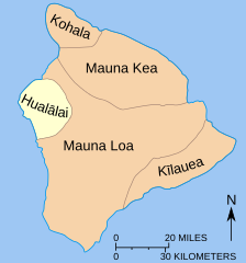
English: Map showing relationship of Hualalai to other volcanoes that form the island of Hawai’i—the Big Island. |
| Date | (UTC) |
| Source | |
| Author |
|
| Other versions |
|


This image is in the public domain in the United States because it only contains materials that originally came from the United States Geological Survey, an agency of the United States Department of the Interior. For more information, see the official USGS copyright policy.
|
Original upload log
[edit]
This image is a derivative work of the following images:
- File:Mapmaunaloa.svg licensed with PD-USGov-USGS
- 2010-07-10T15:16:45Z Richardprins 279x299 (96129 Bytes) Converted last text
- 2010-07-10T15:07:52Z Richardprins 279x299 (77241 Bytes) Had to convert text to path
- 2010-07-10T15:05:16Z Richardprins 279x299 (26562 Bytes) {{Information |Description={{en|Map showing relationship of [[:en:Mauna Loa|Mauna Loa]] to other volcanoes that form the [[:en:Hawaii|Big Island of Hawaii]]}} |Source=*[[:File:Mapmaunaloa.png|]] |Date=2010-07-10 15:03 (UTC) |
Uploaded with derivativeFX
File history
Click on a date/time to view the file as it appeared at that time.
| Date/Time | Thumbnail | Dimensions | User | Comment | |
|---|---|---|---|---|---|
| current | 17:09, 10 July 2010 | | 279 × 299 (94 KB) | Malus Catulus (talk | contribs) | Minor adjustments |
| 16:02, 10 July 2010 |  | 279 × 299 (94 KB) | Malus Catulus (talk | contribs) | {{Information |Description={{en|Map showing relationship of Mauna Loa to other volcanoes that form the Big Island of Hawaii}} |Source=*File:Mapmaunaloa.svg |Date=2010-07-10 16:01 (UTC) |Author=*[[:File:Mapmaunaloa.sv |
You cannot overwrite this file.
File usage on Commons
The following 6 pages use this file:
File usage on other wikis
The following other wikis use this file:
- Usage on ar.wikipedia.org
- Usage on de.wikipedia.org
- Usage on en.wikipedia.org
- Usage on he.wikipedia.org
- Usage on ja.wikipedia.org