File:Guangdong quan sheng shui lu yu tu LOC gm71005159.jpg
Jump to navigation
Jump to search

Size of this preview: 736 × 600 pixels. Other resolutions: 295 × 240 pixels | 589 × 480 pixels | 943 × 768 pixels | 1,257 × 1,024 pixels | 2,514 × 2,048 pixels | 14,152 × 11,530 pixels.
Original file (14,152 × 11,530 pixels, file size: 22.07 MB, MIME type: image/jpeg)
Captions
Captions
Add a one-line explanation of what this file represents
Summary
[edit]| Warning | The original file is very high-resolution. It might not load properly or could cause your browser to freeze when opened at full size. |
|---|
| Description |
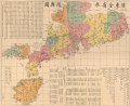
English: Map of Guangdong Province during the late Qing Empire, now the separate territories of Guangdong, Hong Kong, Macau, Hainan, and the coastal strip of Guangxi. Beijing Prime Meridian. Scale c. 1:800,000. Wood block print, hand colored. Available also through the Library of Congress Web site as a raster image. Includes text and list of administrative divisions. AACR2: 651 |
||
| Title | English: Complete Provincial Map of the Lands and Waterways of Guangdong
中文:廣東全省水陸舆图, Guangdong Quan Shengshulu Yutu |
||
| Shelf ID | G7823.G8 1887 .L5 | ||
| Date | |||
| Source | https://www.loc.gov/item/gm71005159/ | ||
| Author | Li Zhongpei | ||
| Permission (Reusing this file) |
|
||
| Other versions |
|
||
| Location | China · Guangdong Sheng | ||
| Part of | American Memory · General Maps · Catalog · Geography And Map Division | ||
| Subject | Maps · Guangdong Sheng (China) · China · Guangdong Sheng |

Licensing
[edit]
|
This is a faithful photographic reproduction of a two-dimensional, public domain work of art. The work of art itself is in the public domain for the following reason:
The official position taken by the Wikimedia Foundation is that "faithful reproductions of two-dimensional public domain works of art are public domain".
This photographic reproduction is therefore also considered to be in the public domain in the United States. In other jurisdictions, re-use of this content may be restricted; see Reuse of PD-Art photographs for details. | ||||
| Annotations | This image is annotated: View the annotations at Commons |
File history
Click on a date/time to view the file as it appeared at that time.
| Date/Time | Thumbnail | Dimensions | User | Comment | |
|---|---|---|---|---|---|
| current | 19:22, 12 June 2018 | | 14,152 × 11,530 (22.07 MB) | Fæ (talk | contribs) | LOC Maps https://www.loc.gov/item/gm71005159/ #28286 |
You cannot overwrite this file.
File usage on Commons
The following page uses this file: