File:Ernst-Ravenstein-Balkans-Ethnic-Map-1880.jpg
Jump to navigation
Jump to search
No higher resolution available.
Ernst-Ravenstein-Balkans-Ethnic-Map-1880.jpg (716 × 563 pixels, file size: 160 KB, MIME type: image/jpeg)
Captions
Captions
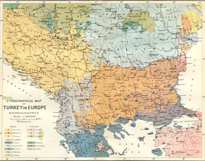
Ethnic composition map of the Balkans by the German-English cartographer E. G. Ravenstein in 1870
Summary
[edit]
| Description |
Български: Етнографска карта на Европейска Турция на Ернст Равенщайн. English: Ernst Ravenstein's Ethnographical Map of Turkey in Europe |
| Date | |
| Source | Self-scanned |
| Author | Ernst Ravenstein (1834 - 1913) |
Licensing
[edit]
|
This work is in the public domain in its country of origin and other countries and areas where the copyright term is the author's life plus 70 years or fewer. | |
| This file has been identified as being free of known restrictions under copyright law, including all related and neighboring rights. | |
File history
Click on a date/time to view the file as it appeared at that time.
| Date/Time | Thumbnail | Dimensions | User | Comment | |
|---|---|---|---|---|---|
| current | 07:49, 18 July 2008 | | 716 × 563 (160 KB) | Мико (talk | contribs) | {{Information |Description={{bg|Етнографска карта на Европейска Турция на Ернст Равенщайн.}}{{en|[[:en:Ernst Georg Ravenstein|Ernst Ravestein's Ethnographical Map of Tur |
You cannot overwrite this file.
File usage on Commons
The following 5 pages use this file:
File usage on other wikis
The following other wikis use this file:
- Usage on ar.wikipedia.org
- Usage on azb.wikipedia.org
- Usage on ba.wikipedia.org
- Usage on bg.wikipedia.org
- Usage on bn.wikipedia.org
- Usage on bs.wikipedia.org
- Usage on ca.wikipedia.org
- Usage on cs.wikipedia.org
- Usage on de.wikipedia.org
- Usage on el.wikipedia.org
- Usage on en.wikipedia.org
- Balkans
- Eastern Rumelia
- Congress of Berlin
- Demographic history of Macedonia
- Talk:Macedonia (region)/Archive 1
- User talk:VMORO
- History of Kosovo
- Bulgarian Exarchate
- Demographic history of Vojvodina
- Bulgarian Turks
- Kosovo vilayet
- User talk:Khoikhoi/Gallery
- Kosovo Albanians
- Ottoman Kosovo
- Muslim minority of Greece
- Greeks in Bulgaria
- Demographic history of Bačka
- Ernst Georg Ravenstein
- User talk:Iadrian yu/Archive May,2012
- User:Falcaorib/Balkans ethnic maps
- Usage on es.wikipedia.org
- Usage on et.wikipedia.org
- Usage on fr.wikipedia.org
- Usage on gl.wikipedia.org
- Usage on he.wikipedia.org
View more global usage of this file.
Metadata
Categories:
- Ernst Georg Ravenstein
- French-language maps showing history
- Historical maps of ethnic groups in Bulgaria
- Historical maps of ethnic groups in Greece
- Historical maps of ethnic groups in North Macedonia
- Historical maps of ethnic groups in Romania
- Historical maps of ethnic groups in Transylvania
- Historical maps of ethnic groups in Serbia
- Historical maps of ethnic groups in Vojvodina
- Historical maps of ethnic groups in Turkey
- Historical maps of ethnic groups in Croatia
- Maps showing 19th-century history
- 1880s maps of the Balkans
- Old maps of Romania
- Historical maps of ethnic groups in the Balkans