File:Austria Occupation Zones 1945-55.svg
Jump to navigation
Jump to search

Size of this PNG preview of this SVG file: 800 × 443 pixels. Other resolutions: 320 × 177 pixels | 640 × 354 pixels | 1,024 × 567 pixels | 1,280 × 708 pixels | 2,560 × 1,417 pixels | 1,355 × 750 pixels.
Original file (SVG file, nominally 1,355 × 750 pixels, file size: 167 KB)
Captions
Captions
Add a one-line explanation of what this file represents
Summary
[edit]
| Description |
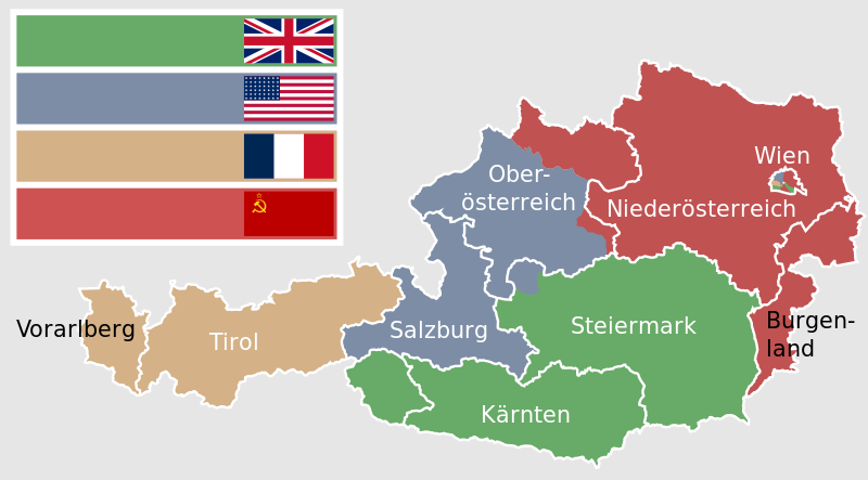
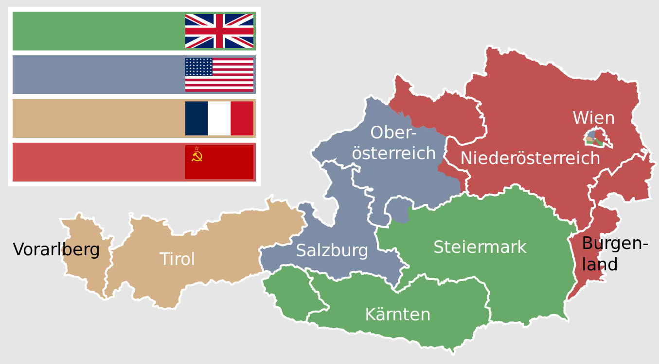
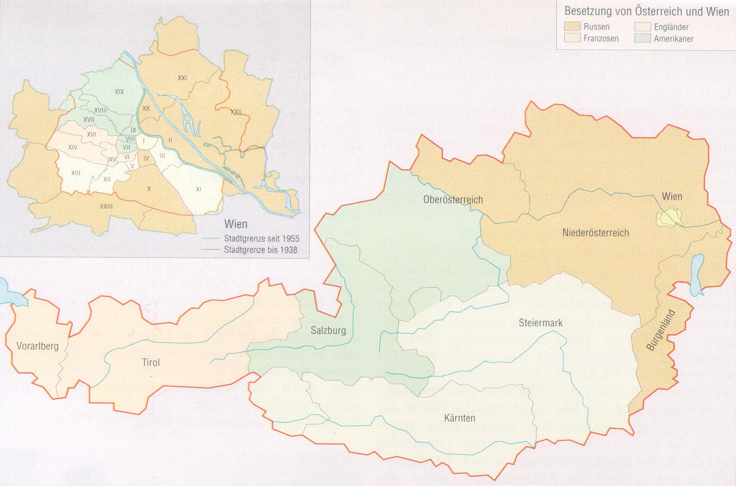
Deutsch: Karte der alliierten Besatzungszonen in Österreich von 1945 bis 1955. Die Grenzen der sowjetischen Zone Wiens entsprechen dem Stand von 1937, alle danach hinzugefügten Flächen zählen besatzungsrechtlich zu Niederösterreich.
Der blau gefärbte Teil innerhalb der Grenze im Nordwesten der Steiermark entspricht dem Übergang des Ausseer Landes zur Steiermark am 1. Juli 1948 und damit in die britische Zone. Die Kartenfärbung stellt den Stand von 1945 dar. English: Map of the allied occupation zones in Austria from 1945 to 1955. The borders of the soviet zone of Vienna are according to the state of the year 1937, every area added aftermath is counted to Lower Austria. |
| Date | |
| Source |
recreation of Austria 1945-55.png using: |
| Author |
|
| Other versions |
Austria 1945-55.png Austria 1945-55.svg |
| SVG development |
.svg)
.svg)
.svg)

|
This image shows a flag, a coat of arms, a seal or some other official insignia. The use of such symbols is restricted in many countries. These restrictions are independent of the copyright status. |
Licensing
[edit]
I, the copyright holder of this work, hereby publish it under the following licenses:

|
Permission is granted to copy, distribute and/or modify this document under the terms of the GNU Free Documentation License, Version 1.2 or any later version published by the Free Software Foundation; with no Invariant Sections, no Front-Cover Texts, and no Back-Cover Texts. A copy of the license is included in the section entitled GNU Free Documentation License. |
This file is licensed under the Creative Commons Attribution-Share Alike 3.0 Unported, 2.5 Generic, 2.0 Generic and 1.0 Generic license.
- You are free:
- to share – to copy, distribute and transmit the work
- to remix – to adapt the work
- Under the following conditions:
- attribution – You must give appropriate credit, provide a link to the license, and indicate if changes were made. You may do so in any reasonable manner, but not in any way that suggests the licensor endorses you or your use.
- share alike – If you remix, transform, or build upon the material, you must distribute your contributions under the same or compatible license as the original.
You may select the license of your choice.
File history
Click on a date/time to view the file as it appeared at that time.
| Date/Time | Thumbnail | Dimensions | User | Comment | |
|---|---|---|---|---|---|
| current | 16:33, 14 February 2023 | | 1,355 × 750 (167 KB) | Kematen (talk | contribs) | östlich der Enns sowj. |
| 11:23, 28 October 2020 |  | 1,355 × 750 (164 KB) | Hanzlan (talk | contribs) | corrected flags (American flag 48 stars/darke blue in French flag) and added name of Vienna | |
| 19:20, 27 October 2020 |  | 1,355 × 750 (153 KB) | Hanzlan (talk | contribs) | all flags same size, corrected the name of Vorarlberg | |
| 22:11, 19 July 2015 |  | 1,355 × 750 (148 KB) | Master Uegly (talk | contribs) | Borders of Vienna changed because soviet occupied areas which were added to Greater Vienna in 1938 were counted to Lower Austria. | |
| 21:31, 19 July 2015 |  | 1,355 × 750 (154 KB) | Master Uegly (talk | contribs) | {{Information |Description={{de|Karte der alliierten Besatzungszonen in Österreich von 1945 bis 1955}} {{en|Map of the allied occupation zones in Austria from 1945 to 1955}} |Source=recreation of {{f|Austria 1945-55.png}} using: * [http://www.aeiou.at... |
You cannot overwrite this file.
File usage on Commons
The following 6 pages use this file:
File usage on other wikis
The following other wikis use this file:
- Usage on af.wikipedia.org
- Usage on ar.wikipedia.org
- Usage on bg.wikipedia.org
- Usage on bh.wikipedia.org
- Usage on ca.wikipedia.org
- Usage on cs.wikipedia.org
- Usage on da.wikipedia.org
- Usage on de.wikipedia.org
- Usage on de.wikibooks.org
- Usage on en.wikipedia.org
- Usage on et.wikipedia.org
- Usage on eu.wikipedia.org
- Usage on fa.wikipedia.org
- Usage on fr.wikipedia.org
- Usage on hu.wikipedia.org
- Usage on ja.wikipedia.org
- Usage on ka.wikipedia.org
- Usage on ko.wikipedia.org
- Usage on nl.wikipedia.org
- Usage on pnb.wikipedia.org
- Usage on pt.wikipedia.org
- Usage on ru.wikipedia.org
- Usage on sk.wikipedia.org
- Usage on th.wikipedia.org
- Usage on uk.wikipedia.org
- Usage on ur.wikipedia.org
- Usage on www.wikidata.org
- Usage on zh.wikipedia.org