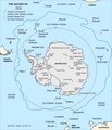
File:Antarctic-Convergence-Map.TIF

Original file (2,373 × 2,768 pixels, file size: 898 KB, MIME type: image/tiff)
Captions
Captions
Summary
[edit]| DescriptionAntarctic-Convergence-Map.TIF | Map of the Antarctic Convergence and the Antarctic region. |
| Date | |
| Source |
Published in: L. Ivanov and N. Ivanova. The World of Antarctica. Generis Publishing, 2022. p. 14. ISBN 979-8-88676-403-1 Original Bulgarian version published in: Ivanov, L. and N. Ivanova. Antarctic: Nature, History, Utilization, Geographic Names and Bulgarian Participation. Sofia: Manfred Wörner Foundation, 2014. p. 9 (in Bulgarian) ISBN 978-619-90008-1-6 |
| Author | own work |
| Other versions | File:Antarctic-Overview-Map.tif, https://commons.wikimedia.org/wiki/File:Antarctic-Overview-Map-EN.tif |
Copyright owner Lyubomir Ivanov alias Apcbg per File:Antarctica-Book-368.TIF.

|
File:Antarctica and the Southern Ocean.svg is a vector version of this file. It should be used in place of this TIF file when not inferior.
File:Antarctic-Convergence-Map.TIF → File:Antarctica and the Southern Ocean.svg
For more information, see Help:SVG.
|
Licensing
[edit]- You are free:
- to share – to copy, distribute and transmit the work
- to remix – to adapt the work
- Under the following conditions:
- attribution – You must give appropriate credit, provide a link to the license, and indicate if changes were made. You may do so in any reasonable manner, but not in any way that suggests the licensor endorses you or your use.
- share alike – If you remix, transform, or build upon the material, you must distribute your contributions under the same or compatible license as the original.
File history
Click on a date/time to view the file as it appeared at that time.
| Date/Time | Thumbnail | Dimensions | User | Comment | |
|---|---|---|---|---|---|
| current | 09:20, 27 November 2022 |  | 2,373 × 2,768 (898 KB) | Apcbg (talk | contribs) | style |
| 19:03, 26 November 2022 |  | 2,373 × 2,768 (898 KB) | Apcbg (talk | contribs) | typo fixed | |
| 10:30, 13 August 2014 |  | 2,373 × 2,768 (980 KB) | Apcbg (talk | contribs) | Alexander Island | |
| 12:16, 12 August 2014 |  | 2,373 × 2,768 (978 KB) | Apcbg (talk | contribs) | {{Information |Description=Map of the Antarctic Convergence. |Source=Ivanov, L. and N. Ivanova. Antarctic: Nature, History, Utilization, Geographic Names and Bulgarian Participation. Sofia: Manfred Wörner Foundation, 2014. p. 9 (in Bulgarian) ISBN 97... |
You cannot overwrite this file.
File usage on Commons
The following 2 pages use this file:
File usage on other wikis
The following other wikis use this file:
- Usage on bg.wikipedia.org
- Usage on de.wikipedia.org
- Usage on en.wikipedia.org
- Usage on en.wikivoyage.org
- Usage on es.wikipedia.org
- Usage on eu.wikipedia.org
- Usage on fa.wikipedia.org
- Usage on id.wikipedia.org
- Usage on ko.wikipedia.org
- Usage on lb.wikipedia.org
- Usage on lt.wikipedia.org
- Usage on mk.wikipedia.org
- Usage on ru.wikipedia.org
- Usage on uk.wikipedia.org
- Usage on www.wikidata.org
Metadata
This file contains additional information such as Exif metadata which may have been added by the digital camera, scanner, or software program used to create or digitize it. If the file has been modified from its original state, some details such as the timestamp may not fully reflect those of the original file. The timestamp is only as accurate as the clock in the camera, and it may be completely wrong.
| Width | 2,373 px |
|---|---|
| Height | 2,768 px |
| Compression scheme | LZW |
| Pixel composition | RGB |
| Orientation | Normal |
| Number of components | 4 |
| Number of rows per strip | 1 |
| Horizontal resolution | 96.012 dpi |
| Vertical resolution | 96.012 dpi |
| Data arrangement | chunky format |
| Software used | IrfanView |
