Category:SVG maps of Morocco
Jump to navigation
Jump to search
Subcategories
This category has the following 5 subcategories, out of 5 total.
Media in category "SVG maps of Morocco"
The following 48 files are in this category, out of 48 total.
-
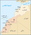
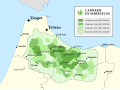 Cannabis en Marruecos 2003.svg 512 × 381; 253 KB
-
 Central Morocco Tamazight.svg 166 × 154; 14 KB
-
 Conquêtes des Saadiens-ar.svg 1,561 × 1,500; 294 KB
-
 Conquêtes des Saadiens-ca.svg 1,561 × 1,500; 18 KB
-
 Conquêtes des Saadiens.svg 1,561 × 1,500; 28 KB
-
 Constituencies of Souss-Massa.svg 1,772 × 1,417; 107 KB
-
 Desastre de Annual.svg 1,529 × 1,205; 512 KB
-
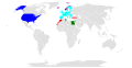
 Hassaniya language distribution.svg 457 × 410; 61 KB
-
 Historical Jewish communities of Morocco.svg 512 × 484; 108 KB
-
 Laâyoune Province in Laâyoune-Sakia El Hamra.svg 1,772 × 1,240; 156 KB
-
 MA y EH.svg 1,000 × 1,000; 188 KB
-
 Map Marrakech.svg 2,634 × 2,364; 10.45 MB
-
 Map MarrakechCentre.svg 2,493 × 2,493; 14.39 MB
-
 Map of ibn Abi Mahalli State - Arabic.svg 746 × 580; 306 KB
-
 Map of Moroccan military regions.svg 879 × 920; 262 KB
-
 Map of Morocco and Western Sahara-ar.svg 625 × 705; 157 KB
-
 Map of Morocco and Western Sahara-fr.svg 625 × 705; 234 KB
-
 Map of Northern Morocco.svg 4,101 × 1,801; 172 KB
-

-
 Mapa de Ifni (1953).svg 2,174 × 1,826; 38 KB
-
 Maroc - Libre Echange.svg 863 × 443; 1.6 MB
-
 Maroc sans cadre.svg 406 × 388; 249 KB
-
 Morocco (legislative local constituencies).svg 800 × 753; 1.54 MB
-
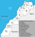 Morocco Regions 2015 numbered.svg 610 × 655; 191 KB
-
 Morocco without Tangier.svg 879 × 920; 128 KB
-
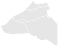
 Provinces of Dakhla-Oued Ed-Dahab.svg 1,772 × 1,417; 236 KB
-
 Provinces of Guelmim-Oued Noun.svg 1,559 × 1,240; 74 KB
-
 Provinces of Laâyoune-Sakia El Hamra.svg 1,772 × 1,240; 156 KB
-
 Regional map of Morocco - 1971.svg 879 × 920; 190 KB
-
 Regional map of Morocco - post 2015.svg 879 × 920; 213 KB
-
 Regionales maroc 2015.svg 7,887 × 7,999; 50 KB
-
 RegionGharbShrardaBenihssen.svg 512 × 436; 107 KB
-
 Regions of Morocco 2015.svg 5,975 × 6,060; 614 KB
-
 Regions of Morocco including Western Sahara.svg 600 × 454; 53 KB
-
 Régions du Maroc 2016.svg 1,912 × 1,939; 25 KB
-
 Sidi Ifni Province in Guelmim-Oued Noun.svg 1,559 × 1,240; 74 KB
-
 SVG-Koort Marokko.svg 700 × 500; 46 KB
-
 Tan-Tan Province in Guelmim-Oued Noun.svg 1,559 × 1,240; 74 KB
-
 Tanger industrias mapa.svg 512 × 498; 180 KB
-
 Tarfaya Province in Laâyoune-Sakia El Hamra.svg 1,772 × 1,240; 156 KB
-
 Taroudant-Nord Constituency in Souss-Massa.svg 1,772 × 1,417; 107 KB
-
 Taroudant-Sud Constituency in Souss-Massa.svg 1,772 × 1,417; 107 KB
-
 Tata Constituency in Souss-Massa.svg 1,772 × 1,417; 107 KB
-
 Tiznit Constituency in Souss-Massa.svg 1,772 × 1,417; 107 KB
-
 Toubkal National Park map.svg 1,223 × 995; 238 KB
-
 Zaian war location map.svg 380 × 367; 305 KB
-
 Поширення Хасанії.svg 457 × 410; 62 KB
-
 Региони во Мароко со Западна Сахара.svg 600 × 454; 72 KB


.svg)
.svg)


.svg)


