Category:Rail transport maps of Emilia-Romagna
Jump to navigation
Jump to search
- Regions of Italy: Abruzzo · Aosta Valley · Apulia · Basilicata · Calabria · Campania · Emilia-Romagna · Friuli-Venezia Giulia · Lazio · Liguria · Lombardy · Marche · Molise · Piedmont · Sardinia · Sicily · Trentino-South Tyrol · Tuscany · Umbria · Veneto
Subcategories
This category has only the following subcategory.
T
Media in category "Rail transport maps of Emilia-Romagna"
The following 34 files are in this category, out of 34 total.
-
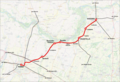
 Mappa ferrovia Alessandria-Piacenza.png 1,377 × 768; 1.39 MB
-
 Ferrovia Barco-Montecchio.png 2,400 × 1,200; 2.07 MB
-
 Ferrovia Budrio-Massalombarda.JPG 1,221 × 639; 72 KB
-
 Mappa ferrovia Castel Bolognese-Riolo Bagni.png 1,024 × 792; 795 KB
-
 Mappa ferrovia Castelbolognese-Ravenna.png 1,174 × 768; 1.13 MB
-
 Progetto servizio ferroviario metropolitano di Ferrara.svg 1,201 × 644; 4.65 MB
-
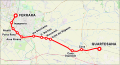
 Ferrara Codigoro Railroad map 2006.gif 718 × 243; 4 KB
-
 Ferrovia Suzzara Ferrara railroad map 2006.gif 794 × 284; 4 KB
-
 Ferrovie reggiane map.gif 533 × 531; 8 KB
-
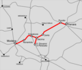
 Mappa ferrovia Fidenza-Fornovo.svg 495 × 469; 3.88 MB
-
 Mappa della ferrovia Fidenza-Salsomaggiore Terme.svg 997 × 650; 1.36 MB
-
 Mappa ferr Ferrara-Modena.png 1,024 × 871; 221 KB
-
 Mappa ferr Subappennina.png 1,024 × 789; 160 KB
-
 Mappa ferr Verona-Bologna.png 1,024 × 952; 246 KB
-
 Mappa ferrovia Bagnolo in Piano-Carpi.png 1,176 × 768; 836 KB
-
 Mappa ferrovia Cremona-Fidenza.png 1,024 × 821; 1.1 MB
-
 Mappa ferrovia Faenza-Lavezzola.svg 771 × 638; 4.88 MB
-
 Mappa SFM Bologna.svg 1,044 × 901; 938 KB
-
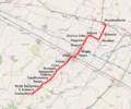 Mappa ferrovia Massalombarda-Imola-Fontanelice.png 1,024 × 854; 1.1 MB
-
 Mappa ferr Milano-Bologna.png 1,159 × 800; 284 KB
-
 Mappa ferrovia Modena-Mirandola.png 1,024 × 1,212; 218 KB
-
 Mappa ferrovia Modena-Mirandola.svg 1,345 × 1,591; 218 KB
-
 Mappa ferrovia Parma-Suzzara.png 1,200 × 824; 1.22 MB
-
 Mappa ferrovia Parma-Suzzara.svg 1,820 × 1,250; 4.29 MB
-
 Mappa ferrovia Piacenza-Bettola.png 1,000 × 1,024; 959 KB
-
 Mappa ferrovia Piacenza-Cremona.svg 1,507 × 859; 3.5 MB
-
 Mappa ferrovia Reggio Emilia-Boretto.png 1,024 × 859; 949 KB
-
 Mappa ferrovia Reggio Emilia-Guastalla.png 1,100 × 1,517; 182 KB
-
 Rete Ferrovie Emilia-Romagna.png 1,024 × 531; 208 KB
-
 Rete ferrovie modenesi 1940.png 1,024 × 1,212; 237 KB
-
 Rete ferrovie modenesi 1940.svg 1,345 × 1,591; 225 KB
-
 Rete Ferrovie reggiane 1950.png 887 × 1,024; 211 KB
-
 Rete SIFT.JPG 1,007 × 656; 91 KB
-
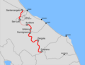
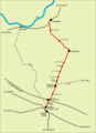
 Tracciato Rimini-San Marino.jpg 903 × 292; 50 KB


