Category:Old maps of the Dutch Gold Coast
Jump to navigation
Jump to search
Subcategories
This category has the following 2 subcategories, out of 2 total.
O
Media in category "Old maps of the Dutch Gold Coast"
The following 99 files are in this category, out of 99 total.
-
 Elmina 1647.jpg 4,004 × 3,235; 1.62 MB
-

-
 DeRuijter-Goudkust.jpg 2,980 × 1,676; 1.26 MB
-
 Jan Luyken - Goudkust.jpg 2,822 × 2,407; 2.63 MB
-
 Bergeman - Elmina (1799).png 2,978 × 2,081; 7.41 MB
-
 Elmina1799.jpg 842 × 608; 415 KB
-
 MeredithGoldküste1812 300dpi.jpg 3,088 × 2,476; 904 KB
-
 KaartNederlandsekolonien.jpg 1,584 × 1,300; 2.39 MB
-
 KaartGoudkust1850 2.jpg 800 × 600; 81 KB
-
 KaartGoudkust1850 3.jpg 800 × 600; 85 KB
-
 KaartGoudkust1850.jpg 800 × 600; 58 KB
-
 KaartGoudkust1865.jpg 800 × 561; 51 KB
-
 Dutch Gold Coast after the Anglo-Dutch forts trade (1867).jpg 640 × 453; 76 KB
-
 DoormanGoldküste1898 300dpi.jpg 3,428 × 2,052; 535 KB
-
 AMH-6780-NA Map of El Mina Fort.jpg 2,400 × 1,730; 663 KB
-
 AMH-7661-NA Map of the Gold Coast.jpg 2,400 × 1,377; 408 KB
-
 AMH-7675-NA Map of the Gold Coast.jpg 2,400 × 2,040; 749 KB
-
 AMH-7676-NA Map of part of the Gold Coast, Axim to Ningo.jpg 2,400 × 1,595; 781 KB
-
 AMH-7677-NA Floorplan of the fort at Axim.jpg 2,400 × 1,934; 620 KB
-
 AMH-7678-NA Floor plan of Ankobra Fort..jpg 1,722 × 2,400; 468 KB
-
 AMH-7679-NA Floor plan of Fort St. Antonie at Axim.jpg 1,372 × 2,400; 428 KB
-
 AMH-7681-NA Floor plan of Fort St. Antonie at Axim.jpg 1,817 × 2,400; 482 KB
-
 AMH-7682-NA Map of the bay of Axim.jpg 2,400 × 1,778; 394 KB
-
 AMH-7683-NA Floor plan of the Hollandia fort at Princes Town.jpg 2,400 × 1,808; 577 KB
-
 AMH-7684-NA Floor plan of the Hollandia fort at Pocquessoe.jpg 1,777 × 2,400; 534 KB
-
 AMH-7685-NA Floor plan of the fort Dorothea at Accoda.jpg 2,400 × 1,800; 477 KB
-
 AMH-7686-NA Floor plan of the Dorothea fort at Accoda.jpg 2,400 × 1,797; 309 KB
-
 AMH-7687-NA Floor plan of the Batenstein fort at Boutrou.jpg 1,735 × 2,400; 413 KB
-
 AMH-7688-NA Floor plan of the Batenstein fort at Butri.jpg 2,400 × 1,772; 308 KB
-
 AMH-7689-NA Floor plan of the Batenstein fort at Butri.jpg 2,400 × 1,811; 655 KB
-
 AMH-7690-NA Floor plan of the fort to be built at Tacorary.jpg 2,400 × 2,133; 617 KB
-
 AMH-7691-NA Floor plan of the fort to be built at Tacorary.jpg 2,400 × 1,892; 288 KB
-
 AMH-7692-NA Floor plan of the Witsen fort at Tacorary.jpg 1,787 × 2,400; 338 KB
-
 AMH-7693-NA Drawing of a rain trough at Tacorary.jpg 2,380 × 2,400; 497 KB
-
 AMH-7694-NA Floor plan of the Oranje fort at Sekondi.jpg 1,728 × 2,400; 342 KB
-
 AMH-7695-NA Floor plan of the Oranje fort at Sekondi.jpg 2,333 × 2,400; 441 KB
-
 AMH-7697-NA Floor plan of the St. Sebastian fort at Chama.jpg 1,713 × 2,400; 364 KB
-
 AMH-7698-NA Fort St. Sebastian at Chama.jpg 2,400 × 1,897; 602 KB
-
 AMH-7699-NA Floor plan of the St. Sebastian fort at Chama.jpg 1,784 × 2,400; 360 KB
-
 AMH-7700-NA Floor plan of the Vreddenburg fort at Kommenda.jpg 1,730 × 2,400; 415 KB
-
 AMH-7701-NA Floor plan of the Vredenburg fort at Kommenda.jpg 2,045 × 2,400; 390 KB
-
 AMH-7704-NA Floor plan of the Vredenburg fort at Komenda.jpg 2,400 × 1,810; 310 KB
-
 AMH-7705-NA Floor plan of the Vredenburg fort at Komenda.jpg 2,400 × 1,886; 291 KB
-
 AMH-7709-NA Floor plan of Fort Elmina.jpg 2,400 × 1,822; 492 KB
-
 AMH-7712-NA Floor plan of Fort Elmina.jpg 2,400 × 1,831; 692 KB
-
 AMH-7713-NA Floor plan of Fort Coenraadsburg.jpg 2,400 × 1,820; 715 KB
-
 AMH-7714-NA Floor plan of Fort Coenraadsburg.jpg 1,874 × 2,400; 365 KB
-
 AMH-7715-NA Two floor plans of Fort St. George at Elmina.jpg 1,577 × 2,400; 538 KB
-
 AMH-7716-NA Floor plan of the extension to Fort St. George at Elmina in 1782.jpg 2,400 × 1,550; 351 KB
-
 AMH-7717-NA Floor plan of the Coenraadsburg and St. George forts at Elmina.jpg 2,400 × 865; 317 KB
-
 AMH-7718-NA Floor plan of the 'kattenplaats' courtyard in Fort St. George at Elmina.jpg 2,400 × 1,952; 596 KB
-
 AMH-7719-NA Floor plan of part of Fort St. George at Elmina.jpg 2,400 × 2,050; 582 KB
-
 AMH-7720-NA Floor plan of a part of Fort St. George at Elmina.jpg 1,052 × 2,400; 295 KB
-
 AMH-7721-NA Floor plan of a part of Fort St. George at Elmina.jpg 822 × 2,400; 225 KB
-
 AMH-7722-NA Floor plan of a part of Fort St. George at Elmina.jpg 1,343 × 2,400; 359 KB
-
 AMH-7723-NA Floor plan of the Coenraadsburg fort at Elmina.jpg 2,400 × 1,859; 630 KB
-
 AMH-7724-NA Map of Elmina showing the forts of St. George and Coenraadsburg.jpg 2,400 × 1,674; 594 KB
-
 AMH-7726-NA Floor plan of the Nassau fort at Mouri.jpg 1,245 × 2,400; 443 KB
-
 AMH-7727-NA Floor plan of the Nassau fort at Mouri.jpg 1,823 × 2,400; 420 KB
-
 AMH-7728-NA Floor plan of the Amsterdam fort at Cormantin.jpg 1,175 × 2,400; 478 KB
-
 AMH-7729-NA Floor plan of the Amsterdam fort at Cormantin.jpg 1,846 × 2,400; 450 KB
-
 AMH-7730-NA Floor plan of the Lijdzaamheid fort at Apam.jpg 1,154 × 2,400; 463 KB
-
 AMH-7731-NA Floor plan of the Lydzaamheid fort at Apam.jpg 2,400 × 1,913; 424 KB
-
 AMH-7733-NA Floor plan of Fort Goede Hoop at Berku.jpg 1,572 × 2,400; 643 KB
-
 AMH-7734-NA Floor plan of Fort Goede Hoop in Bercou.jpg 2,400 × 1,862; 350 KB
-
 AMH-7735-NA Floor plan of Fort Goede Hoop at Berku.jpg 2,400 × 1,917; 438 KB
-
 AMH-7736-NA Floor plan of Fort Crevecoeur at Accra.jpg 2,400 × 1,940; 396 KB
-
 AMH-7737-NA Floor plan of Fort Crevecoeur at Accra.jpg 2,400 × 1,890; 314 KB
-
 AMH-7945-KB Map of the Gold Coast.jpg 2,400 × 1,352; 687 KB
-

-
 AMH-8070-KB Map of part of the Gold Coast.jpg 2,400 × 1,809; 706 KB
-
 AMH-8071-KB Map of the Gold Coast from Cape Apollonia to the Volta River.jpg 2,400 × 1,289; 562 KB
-
 AMH-8073-KB Floor plan of the Dutch fort at Sama.jpg 1,743 × 2,400; 493 KB
-
 AMH-8076-KB Floor plan of the fort of Dickscove.jpg 1,669 × 2,400; 538 KB
-
 AMH-8170-KB Map of the Gold Coast.jpg 2,400 × 1,377; 667 KB
-
 AMH-8174-KB Views of the forts at Dickscove and Sakkundi.jpg 2,400 × 1,692; 1.1 MB
-
 AMH-8178-KB View of the English and Dutch forts at Akkra, seen from the north.jpg 2,400 × 1,629; 1,005 KB
-
 AMH-8650-NA Map of the Gold Coast.jpg 2,400 × 1,896; 481 KB
-

-

-
 FortsGoldküste.JPG 1,200 × 783; 300 KB
-

-
-
 Kaart van de Goud-Kust of Kust van Guinea (1818).jpg 7,377 × 5,983; 3.16 MB
-

-
 Plan du château de la Minne en Guinée.jpg 5,184 × 3,968; 2.6 MB
-
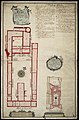
 Plattegrond van het fort Batenstein te Boutry, kust van Guinea (1841).jpg 6,370 × 4,407; 1.95 MB
-
 Plattegrond van het fort Crêvecoeur te Hollands Accra, Kust van Guinea.jpg 5,000 × 3,486; 1,023 KB
-
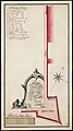
 Plattegrond van het fort Oranje te Saccondie, kust van Guinea.jpg 5,350 × 6,319; 1.87 MB
-

-
-

-

-

-
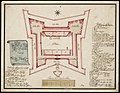
 Standteekening van het fort Batenstein te Boutry, kust van Guinea.jpg 6,547 × 4,600; 1.59 MB
-
 Standteekening van het fort Commenda.jpg 4,103 × 2,915; 719 KB
-
 Standteekening van het fort Crêvecoeur te Hollandsch Accra, Kust van Guinea.jpg 6,342 × 3,354; 1.02 MB
-
 Standteekening van het fort Oranje te Saccondee, kust van Guinea.jpg 6,294 × 4,339; 1.26 MB
-
 Standteekening van het fort te Nederlandsch Commany.jpg 4,137 × 2,856; 761 KB


.png)


.jpg)


,_NG-1998-9.jpg)
.jpg)

.jpg)


.jpg)


.jpg)