Category:NYPL collection of Atlases, gazetteers, guidebooks and other books
In 1997, on the death of Lawrence H. Slaughter, part of his magnificent private map collection came to NYPL from his estate, as a gift from his family. In 2001, the second half of the collection was given to the Map Division. His collection of maps focuses on the Middle Atlantic region, and formed the basis for the exhibition "In thy map securely saile."
Another private collection came to NYPL in 1990 from the John H. Levine estate, comprised of a wonderful miscellany of antique maps for places around the world, from the Holy Lands to Bermuda, providing additional specimens for this digital presentation.
Ref http://digitalcollections.nypl.org/collections/b28be120-c602-012f-769c-58d385a7bc34
Subcategories
This category has the following 2 subcategories, out of 2 total.
Media in category "NYPL collection of Atlases, gazetteers, guidebooks and other books"
The following 200 files are in this category, out of 469 total.
(previous page) (next page)-

-

-

-
 Nieuwe Werelt kaert (NYPL b13647135-ps map cd7 081).jpg 4,072 × 4,072; 6.54 MB
-

-

-
 Dominii Veneti in Italia (NYPL b13654243-psnypl map 311).tiff 5,366 × 4,810; 73.85 MB
-
 Province de Chen-si no. 16 (NYPL b13654478-5053010).tiff 9,756 × 7,699, 2 pages; 215.17 MB
-
 Province de Chen-si no. 16 (NYPL b13654478-5053011).tiff 10,328 × 7,374, 2 pages; 218.16 MB
-

-
 1863 map- Plan of New Orleans (NYPL b13663520-1510812) (cropped).tiff 4,331 × 3,466; 43.61 MB
-
 Plan of New Orleans (NYPL b13663520-1510812).tiff 6,298 × 5,246; 95.18 MB
-
 County map of Ohio and Indiana (NYPL b13663520-1510814).jpg 4,921 × 3,930; 6.22 MB
-
 Plan of Cincinnati and vicinity (NYPL b13663520-1510815).tiff 6,299 × 5,248; 95.24 MB
-
 List of Post Offices in the United States. (B) (NYPL b13663520-1510840).tiff 5,248 × 6,299; 95.23 MB
-
 List of Post Offices in the United States. (C) (NYPL b13663520-1510842).tiff 5,248 × 6,299; 95.23 MB
-
 List of Post Offices in the United States. (C, D) (NYPL b13663520-1510843).tiff 5,248 × 6,299; 95.23 MB
-
 List of Post Offices in the United States. (S, T) (NYPL b13663520-1510857).jpg 5,248 × 6,299; 9.54 MB
-
 List of Post Offices in the United States. (D, E) (NYPL b13663520-1510844).tiff 5,248 × 6,299; 95.23 MB
-
 List of Post Offices in the United States. (T, U, V, W) (NYPL b13663520-1510858).jpg 5,248 × 6,299; 9.29 MB
-
 List of Post Offices in the United States. (E, F) (NYPL b13663520-1510845).tiff 5,248 × 6,299; 95.23 MB
-
 List of Post Offices in the United States. (W) (NYPL b13663520-1510859).jpg 5,248 × 6,299; 9.38 MB
-
 List of Post Offices in the United States. (F, G, H) (NYPL b13663520-1510846).tiff 5,248 × 6,299; 95.23 MB
-
 List of Post Offices in the United States. (W, X, Y, Z) (NYPL b13663520-1510860).jpg 5,248 × 6,299; 8.77 MB
-
 List of Post Offices in the United States. (H) (NYPL b13663520-1510847).tiff 5,248 × 6,299; 95.23 MB
-
 List of Post Offices in the United States. (H, I, J, K, L) (NYPL b13663520-1510848).tiff 5,248 × 6,299; 95.23 MB
-
 List of Post Offices in the United States. (L) (NYPL b13663520-1510849).tiff 5,248 × 6,299; 95.23 MB
-
 List of Post Offices in the United States. (L, M) (NYPL b13663520-1510850).tiff 5,248 × 6,299; 95.23 MB
-
 List of Post Offices in the United States. (M, N) (NYPL b13663520-1510851).tiff 5,248 × 6,299; 95.23 MB
-
 List of Post Offices in the United States. (N, O) (NYPL b13663520-1510852).tiff 5,248 × 6,299; 95.23 MB
-
 List of Post Offices in the United States. (O, P) (NYPL b13663520-1510853).tiff 5,248 × 6,299; 95.23 MB
-
 List of Post Offices in the United States. (P, Q, R) (NYPL b13663520-1510854).tiff 5,248 × 6,299; 95.23 MB
-
 List of Post Offices in the United States. (R, S) (NYPL b13663520-1510855).tiff 5,248 × 6,299; 95.23 MB
-
 List of Post Offices in the United States. (S) (NYPL b13663520-1510856).tiff 5,248 × 6,299; 95.23 MB
-
 List of Post Offices in the United States. (S, T) (NYPL b13663520-1510857).tiff 5,248 × 6,299; 95.23 MB
-
 List of Post Offices in the United States. (T, U, V, W) (NYPL b13663520-1510858).tiff 5,248 × 6,299; 95.23 MB
-
 List of Post Offices in the United States. (W) (NYPL b13663520-1510859).tiff 5,248 × 6,299; 95.23 MB
-
 List of Post Offices in the United States. (W, X, Y, Z) (NYPL b13663520-1510860).tiff 5,248 × 6,299; 95.23 MB
-
 Population of the United States. By the census of 1850 and 1860 (NYPL b13663520-1510861).tiff 5,248 × 6,299; 95.23 MB
-
 Population of the United States in 1850 and 1860 (NYPL b13663520-1510862).tiff 5,248 × 6,299; 95.23 MB
-
 Mountains of the world (NYPL b13663520-1510865).tiff 5,248 × 6,299; 95.23 MB
-
 Johnson's Florida (NYPL b13663522-5578043).tiff 7,760 × 10,328, 2 pages; 229.61 MB
-
 Johnson's Florida (NYPL b13663522-5609438).tiff 7,760 × 10,328, 2 pages; 229.61 MB
-
 Plan général d'Alexandrie avec ses embellissements récents, 1930; Plan général de Ramleh (NYPL b13668586-3985303).tiff 7,216 × 5,412, 2 pages; 112 MB
-
 Plan général d'Alexandrie avec ses embellissements récents, 1930; Plan général de Ramleh (NYPL b13668586-3985304).tiff 7,216 × 5,412, 2 pages; 112 MB
-

-
 Dioecesis Trundhemiensis pars Australis (NYPL b13908774-1696028).jpg 6,194 × 4,856; 5.56 MB
-
 Episcopatus Bergensis (NYPL b13908774-1696027).jpg 6,194 × 4,856; 5.87 MB
-
 Title page (NYPL b13908777-ps map 191).jpg 3,384 × 4,061; 4.26 MB
-
 De zee-atlas ofte water-wereld ... (Title page) (NYPL b13908778-1619019).jpg 3,631 × 6,132; 6.76 MB
-
 Pascaart van Europa (NYPL b13908778-1619021).jpg 5,418 × 4,512; 6.59 MB
-
 Pascaart van de Noort zee (NYPL b13908778-1619022).jpg 5,528 × 4,567; 6.59 MB
-
 Pascaart van de Noort zee (NYPL b13908778-1619022).tiff 7,230 × 5,428; 112.28 MB
-
 Pas-caart van de Oost zee (NYPL b13908778-1619023).jpg 5,586 × 4,607; 6.73 MB
-
 Pas-caart van de Oost zee (NYPL b13908778-1619023).tiff 7,230 × 5,428; 112.28 MB
-
 Pascaarte van de Zuyder-zee (NYPL b13908778-1619024).jpg 5,280 × 4,440; 6.88 MB
-
 Pascaarte van de Zuyder-zee (NYPL b13908778-1619024).tiff 7,230 × 5,428; 112.28 MB
-
 Pascaart van de Noord Zee, van Texel tot de Hoofden (NYPL b13908778-1619025).jpg 5,508 × 4,554; 7.01 MB
-
 Cust van Hollant tusschen de Maes ende Texel (NYPL b13908778-1619026).jpg 5,397 × 4,440; 6.82 MB
-
-

-

-

-

-

-

-
 Het Canaal tusschen Engeland en Vrancrijck (NYPL b13908778-1619032).jpg 5,550 × 4,560; 7.02 MB
-

-
 Paskaarte om achter Yrlandt om te zeylen, van Hitlandt tot aen Heyssat (NYPL b13908778-1619033).tiff 7,230 × 5,428; 112.28 MB
-
 Paskaert van't in comen van't Canaal (NYPL b13908778-1619034).jpg 5,460 × 4,518; 6.36 MB
-
 Paskaert van't in comen van't Canaal (NYPL b13908778-1619034).tiff 7,230 × 5,428; 112.28 MB
-
-

-

-
 Paskaerte van't westelijckste der Middelandsche Zee (NYPL b13908778-1619037).jpg 5,358 × 4,290; 6.17 MB
-
 Paskaerte van't westelijckste der Middelandsche Zee (NYPL b13908778-1619037).tiff 7,230 × 5,428; 112.28 MB
-
 Paskaerte van't oostelijckste der Middelandsche Zee (NYPL b13908778-1619038).jpg 5,280 × 4,200; 6.09 MB
-

-

-

-

-

-

-
-

-

-
 Noordtoost cust van Asia, van Japan tot Nova Zemla (NYPL b13908778-1619046).jpg 5,472 × 4,632; 6.33 MB
-

-

-

-

-

-

-

-

-

-

-

-
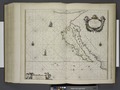
 Pascaerte van Westindien, de vaste kusten en de Eylanden (NYPL b13908778-1619053).jpg 5,463 × 4,613; 6.88 MB
-
 Pascaerte van Westindien, de vaste kusten en de Eylanden (NYPL b13908778-1619053).tiff 7,230 × 5,428; 112.28 MB
-
 Pascaert van de Caribes Eylanden (NYPL b13908778-1619054).jpg 5,430 × 4,584; 5.79 MB
-
 Pascaert van de Caribes Eylanden (NYPL b13908778-1619054).tiff 7,230 × 5,428; 112.28 MB
-
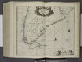
 Paskaart van Brazil van Rio de los Amazones tot Rio de la Plata (NYPL b13908778-1619055).jpg 5,478 × 4,644; 6.04 MB
-
 Paskaart van Brazil van Rio de los Amazones tot Rio de la Plata (NYPL b13908778-1619055).tiff 7,230 × 5,428; 112.28 MB
-

-
-
 Pascaerte van Nova Hispania, Chili, Peru, en Gvatimala (NYPL b13908778-1619057).jpg 5,412 × 4,632; 6.63 MB
-
 Pascaerte van Nova Hispania, Chili, Peru, en Gvatimala (NYPL b13908778-1619057).tiff 7,230 × 5,428; 112.28 MB
-
 Paskaerte van Nova Granada en t'Eylandt California (NYPL b13908778-1619058).jpg 5,448 × 4,644; 5.94 MB
-
 Paskaerte van Nova Granada en t'Eylandt California (NYPL b13908778-1619058).tiff 7,230 × 5,428; 112.28 MB
-

-
 Pascaerte vande Zvyd-zee tussche California, en Ilhas de Ladrones (NYPL b13908778-1619018).tiff 7,230 × 5,428; 112.28 MB
-
 De zee-atlas ofte water-wereld (title page) (NYPL b13908780-ps map 183).jpg 4,072 × 4,072; 4.7 MB
-
 The Sea-Atlas (NYPL b13909432-1640702).jpg 4,537 × 6,998; 5.25 MB
-

-
 The Sea-Atlas (NYPL b13909432-1640704).jpg 3,562 × 5,670; 6.03 MB
-
 The Sea-Atlas (NYPL b13909432-1640706).jpg 3,524 × 5,470; 5.82 MB
-
 The Sea-Atlas (NYPL b13909432-1640707).jpg 3,558 × 5,524; 5.59 MB
-
 The Sea-Atlas (NYPL b13909432-1640708).jpg 3,585 × 5,601; 5.82 MB
-
 The Sea-Atlas (NYPL b13909432-1640709).jpg 3,494 × 5,544; 5.9 MB
-
 The Sea-Atlas (NYPL b13909432-1640710).jpg 3,492 × 5,520; 5.13 MB
-
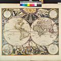
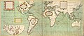
 A new mapp of the world (NYPL b13909432-1640711).jpg 5,964 × 4,823; 9.33 MB
-
 A new mapp of the world (NYPL b13909432-1640711).tiff 7,230 × 5,428; 112.28 MB
-
 A new and correct Mapp of the WORLD (NYPL b13909432-1640712).jpg 6,939 × 4,236; 8.53 MB
-
-

-

-

-

-

-

-
 A chart of the WHITE SEA with the River Dwina (NYPL b13909432-1640715).jpg 5,811 × 4,726; 6.14 MB
-

-

-
 The Chart of FINMARCK from Sanien to North-Kyn or North point (NYPL b13909432-1640718).jpg 5,839 × 4,776; 6.76 MB
-
 The Chart of FINMARCK from Dronten to Tromsound (NYPL b13909432-1640719).jpg 5,787 × 4,767; 6.75 MB
-
-
 The chart of the Leeth of BERGEN from Schuytenes to Bergen (NYPL b13909432-1640722).jpg 5,796 × 4,728; 6.16 MB
-
 The coast of NORWAY; between the Naze and Schuytenes (NYPL b13909432-1640723).jpg 5,789 × 4,769; 6.73 MB
-

-
 A chart of the BELT and SOUND (NYPL b13909432-1640725).jpg 6,690 × 3,838; 7.17 MB
-
 A chart of the EAST-SEA (NYPL b13909432-1640726).jpg 8,880 × 4,944; 7.5 MB
-

-
 A chart of PRUSSIA and Coerland from Rygshead to Der Winda (NYPL b13909432-1640728).jpg 5,829 × 4,792; 6.57 MB
-

-

-
 A chart of coast SWEDEN from Oeland to Stockholm (NYPL b13909432-1640731).jpg 5,831 × 4,776; 6.65 MB
-
 The channell of ABBO or UTTOY; A chart of STOCKHOLM Leith (NYPL b13909432-1640732).jpg 5,841 × 4,785; 6.88 MB
-
 A chart of JUTLAND and the Islands of Omtren (NYPL b13909432-1640696).jpg 5,780 × 4,770; 6.98 MB
-

-
-

-

-
 A chart of the Sea-Coast of ZEALAND from Walcheren to the Macs (NYPL b13909432-1640701).jpg 5,768 × 4,825; 6.77 MB
-

-
 A chart of the NORTH SEA (NYPL b13909432-1640558).jpg 5,931 × 4,880; 7.99 MB
-

-

-

-

-
 Part of the Maine Island of Shetland (NYPL b13909432-1640562).jpg 6,119 × 4,900; 6.92 MB
-
 The cheife Harbours in the Islands of ORKNEY (NYPL b13909432-1640563).jpg 6,120 × 4,893; 6.5 MB
-
 Moray Firth and Sutherland, Scotland (NYPL b13909432-1640564).jpg 6,144 × 4,826; 7.08 MB
-

-
 BURLINGTON BAY, Scarbrouth and Hartlepoole (NYPL b13909432-1640566).jpg 6,139 × 4,887; 6.15 MB
-
 A chart of the east coast of Scotland (NYPL b13909432-1640567).jpg 5,817 × 4,734; 6.78 MB
-
-

-
 A new chart of the IRISH SEA (NYPL b13909432-1640576).jpg 5,851 × 4,800; 7.1 MB
-

-
 A chart of the BAY OF GALLOWAY and RIVER SHANNON (NYPL b13909432-1640581).jpg 5,774 × 4,824; 5.41 MB
-

-
 The county of Waterford (NYPL b13909432-1640583).jpg 5,864 × 4,863; 5.04 MB
-
 The Harbour of Corke (NYPL b13909432-1640584).jpg 5,859 × 4,845; 5.44 MB
-
 The sea-coasts of FRANCE from Calais to the River Seine (NYPL b13909432-1640585).jpg 6,292 × 4,977; 6.43 MB
-
 The sea-coast of FRANCE from Havre de Grace to Cape de Barfleur (NYPL b13909432-1640586).jpg 6,267 × 4,976; 6.13 MB
-
-
 The coast of BRETAGNE from GRANVILLE to CAPEFREHEL (NYPL b13909432-1640588).jpg 6,426 × 3,942; 5.63 MB
-
 The coast of BRETAGNE from Pleherel to Isle of Gueltas (NYPL b13909432-1640589).jpg 6,285 × 4,999; 6.21 MB
-
 The coast of BRETAGNE from I - Gueltas to Plougoulin (NYPL b13909432-1640590).jpg 6,363 × 5,097; 6.45 MB
-
 The coast of BRETAGNE from Plougoulin to Passage Du Four (NYPL b13909432-1640591).jpg 6,309 × 5,069; 6.16 MB
-
 The coast of BRETAGNE including the bay of BREST and DOVARNENEZ (NYPL b13909432-1640592).jpg 6,222 × 4,970; 6.63 MB
-
 A chart of the sea coast from ENGLAND to the STREIGHTS (NYPL b13909432-1640593).jpg 5,911 × 4,866; 6.99 MB
-

-

-
 The coast of BRETAGNE from the Penmarks to Port Douelan (NYPL b13909432-1640596).jpg 6,237 × 4,983; 6.1 MB
-
 The coast of BRETAGNE from Port Douelan to Point Penvis (NYPL b13909432-1640597).jpg 6,357 × 5,034; 6.81 MB
-

-

-
 The River of BOURDEAUX and Bay of ARCASSON (NYPL b13909432-1640600).jpg 6,280 × 4,915; 6.19 MB
-

-

-

-
 The city and harbour of CADIZ (NYPL b13909432-1640609).jpg 5,935 × 4,935; 5.91 MB
-
 The city of LIMA where the vice Roy of Peru is Resident (NYPL b13909432-1640610).jpg 5,768 × 4,576; 5.39 MB
-

-
 A new draught of the coast of GUINEA and BRASILE (NYPL b13909432-1640612).jpg 6,259 × 5,249; 7.65 MB
-
-

-
 The Iland of Babados; Island of Bermuda (NYPL b13909432-1640615).jpg 5,758 × 4,755; 6.14 MB
.jpg)
.jpg)
.jpg)
_(NYPL_b13663520-1510857).jpg)
_(NYPL_b13663520-1510858).jpg)
_(NYPL_b13663520-1510859).jpg)
_(NYPL_b13663520-1510860).jpg)
.jpg)
.jpg)
.jpg)
_(NYPL_b13908778-1619019).jpg)
.jpg)
.jpg)
.jpg)
.jpg)
.jpg)
.jpg)
.jpg)
.jpg)
.jpg)
.jpg)
.jpg)
.jpg)
.jpg)
.jpg)
.jpg)
.jpg)
.jpg)
.jpg)
.jpg)
.jpg)
.jpg)
.jpg)
.jpg)
.jpg)
.jpg)
.jpg)
.jpg)
.jpg)
.jpg)
.jpg)
.jpg)
.jpg)
.jpg)
.jpg)
.jpg)
.jpg)
.jpg)
.jpg)
.jpg)
_(NYPL_b13908780-ps_map_183).jpg)
.jpg)
.jpg)
.jpg)
.jpg)
.jpg)
.jpg)
.jpg)
.jpg)
.jpg)
.jpg)
.jpg)
.jpg)
.jpg)
.jpg)
.jpg)
.jpg)
.jpg)
.jpg)
.jpg)
.jpg)
.jpg)
.jpg)
.jpg)
.jpg)
.jpg)
.jpg)
.jpg)
.jpg)
.jpg)
.jpg)
.jpg)
.jpg)
.jpg)
.jpg)
.jpg)
.jpg)
.jpg)
.jpg)
.jpg)
.jpg)
.jpg)
.jpg)
.jpg)
.jpg)
.jpg)
.jpg)
.jpg)
.jpg)
.jpg)
.jpg)
.jpg)
.jpg)
.jpg)
.jpg)
.jpg)
.jpg)
.jpg)
.jpg)
.jpg)
.jpg)
.jpg)
.jpg)
.jpg)
.jpg)
.jpg)
.jpg)
.jpg)
.jpg)
.jpg)
.jpg)
.jpg)
.jpg)
.jpg)
.jpg)
.jpg)
.jpg)
.jpg)
.jpg)
.jpg)
.jpg)
.jpg)
.jpg)
.jpg)