Category:NYPL Lionel Pincus and Princess Firyal Map Division
Jump to navigation
Jump to search
Subcategories
This category has the following 7 subcategories, out of 7 total.
K
M
Media in category "NYPL Lionel Pincus and Princess Firyal Map Division"
The following 200 files are in this category, out of 1,224 total.
(previous page) (next page)-
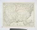
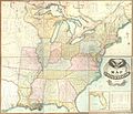 Lay's map of the United States (NYPL b11070797-1253199).jpg 10,661 × 9,149; 29.83 MB
-
 Lay's map of the United States (NYPL b11070797-1949365).jpg 3,691 × 4,741; 5.65 MB
-
 Lay's map of the United States (NYPL b11070797-1949366).jpg 3,727 × 4,709; 5.51 MB
-
 Lay's map of the United States (NYPL b11070797-1949367).jpg 3,609 × 4,745; 5.56 MB
-
 Lay's map of the United States (NYPL b11070797-1949368).jpg 3,688 × 4,681; 5.4 MB
-
 Lay's map of the United States (NYPL b11070797-1949369).jpg 3,658 × 4,755; 5.11 MB
-
 Lay's map of the United States (NYPL b11070797-1253199).tiff 10,661 × 9,149; 279.13 MB
-
 Lay's map of the United States (NYPL b11070797-1949370).jpg 3,713 × 4,716; 4.68 MB
-
 Lay's map of the United States (NYPL b11070797-1949365).tiff 4,091 × 4,997; 58.49 MB
-
 Lay's map of the United States (NYPL b11070797-1949366).tiff 4,101 × 4,953; 58.12 MB
-
 Lay's map of the United States (NYPL b11070797-1949367).tiff 4,074 × 4,953; 57.74 MB
-
 Lay's map of the United States (NYPL b11070797-1949368).tiff 4,074 × 4,953; 57.74 MB
-
 Lay's map of the United States (NYPL b11070797-1949369).tiff 4,074 × 4,953; 57.74 MB
-
 Lay's map of the United States (NYPL b11070797-1949370).tiff 4,101 × 4,960; 58.2 MB
-

-

-

-

-

-
 List of maps (NYPL b13663520-1510789).tiff 5,246 × 6,298; 94.54 MB
-

-

-
 New Hampshire and Vermont (NYPL b13663520-1510798).tiff 4,160 × 5,220; 62.79 MB
-
 Plan of New Orleans (NYPL b13663520-1510812).jpg 4,129 × 3,477; 4.45 MB
-
 Plan of New York, &c (NYPL b13663520-1510801).tiff 3,996 × 4,851; 74.61 MB
-
 Plan of Boston (NYPL b13663520-1510802).tiff 3,514 × 4,155; 42.43 MB
-
 Plan of Philadelphia (NYPL b13663520-1510804).tiff 4,830 × 4,043; 75.15 MB
-
 Plan of Baltimore (NYPL b13663520-1510805).tiff 4,147 × 3,524; 41.83 MB
-

-
 County map of Kentucky and Tennessee (NYPL b13663520-1510808).tiff 5,044 × 3,951; 57.68 MB
-
 County map of Georgia and Alabama (NYPL b13663520-1510809).jpg 4,995 × 3,962; 6.67 MB
-

-
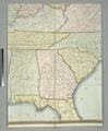
 Map of Louisiana, Mississippi, and Arkansas (NYPL b13663520-1510811).jpg 3,955 × 5,070; 6.56 MB
-
 1863 map- Plan of New Orleans (NYPL b13663520-1510812) (cropped).tiff 4,331 × 3,466; 43.61 MB
-
 Plan of New Orleans (NYPL b13663520-1510812).tiff 6,298 × 5,246; 95.18 MB
-
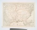
 County map of Texas; Galveston Bay and vicinity (inset) (NYPL b13663520-1510813).jpg 5,067 × 4,084; 6.45 MB
-
 County map of Ohio and Indiana (NYPL b13663520-1510814).jpg 4,921 × 3,930; 6.22 MB
-
 Plan of Cincinnati and vicinity (NYPL b13663520-1510815).tiff 6,299 × 5,248; 95.24 MB
-
 Prussia, and the German States (NYPL b13663520-1510832).jpg 5,012 × 3,985; 6.01 MB
-

-

-

-

-

-

-

-

-

-
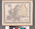 Map of Europe, showing its gt. political divisions (NYPL b13663520-1510827).jpg 5,002 × 4,020; 6.26 MB
-
 Map of Denmark (NYPL b13663520-1510828).jpg 1,105 × 1,777; 768 KB
-

-

-
 Map of Switzerland in cantons (inset) (NYPL b13663520-1510829).jpg 1,424 × 1,016; 541 KB
-
 County map of England and Wales (NYPL b13663520-1510830) (cropped).jpg 4,007 × 5,053; 6.83 MB
-
 County map of England and Wales (NYPL b13663520-1510830).jpg 5,248 × 6,299; 8.99 MB
-

-

-
 Prussia, and the German States (NYPL b13663520-1510832).tiff 6,299 × 5,248; 95.24 MB
-

-

-
 List of Post Offices in the United States. (A, B) (NYPL b13663520-1510839).tiff 5,248 × 6,299; 95.23 MB
-
 List of Post Offices in the United States. (B) (NYPL b13663520-1510840).tiff 5,248 × 6,299; 95.23 MB
-
 List of Post Offices in the United States. (B, C) (NYPL b13663520-1510841).tiff 5,248 × 6,299; 95.23 MB
-
 List of Post Offices in the United States. (C) (NYPL b13663520-1510842).tiff 5,248 × 6,299; 95.23 MB
-
 List of Post Offices in the United States. (C, D) (NYPL b13663520-1510843).tiff 5,248 × 6,299; 95.23 MB
-
 List of Post Offices in the United States. (S, T) (NYPL b13663520-1510857).jpg 5,248 × 6,299; 9.54 MB
-
 List of Post Offices in the United States. (D, E) (NYPL b13663520-1510844).tiff 5,248 × 6,299; 95.23 MB
-
 List of Post Offices in the United States. (T, U, V, W) (NYPL b13663520-1510858).jpg 5,248 × 6,299; 9.29 MB
-
 List of Post Offices in the United States. (E, F) (NYPL b13663520-1510845).tiff 5,248 × 6,299; 95.23 MB
-
 List of Post Offices in the United States. (W) (NYPL b13663520-1510859).jpg 5,248 × 6,299; 9.38 MB
-
 List of Post Offices in the United States. (F, G, H) (NYPL b13663520-1510846).tiff 5,248 × 6,299; 95.23 MB
-
 List of Post Offices in the United States. (W, X, Y, Z) (NYPL b13663520-1510860).jpg 5,248 × 6,299; 8.77 MB
-
 List of Post Offices in the United States. (H) (NYPL b13663520-1510847).tiff 5,248 × 6,299; 95.23 MB
-
 List of Post Offices in the United States. (H, I, J, K, L) (NYPL b13663520-1510848).tiff 5,248 × 6,299; 95.23 MB
-
 List of Post Offices in the United States. (L) (NYPL b13663520-1510849).tiff 5,248 × 6,299; 95.23 MB
-
 List of Post Offices in the United States. (L, M) (NYPL b13663520-1510850).tiff 5,248 × 6,299; 95.23 MB
-
 List of Post Offices in the United States. (M, N) (NYPL b13663520-1510851).tiff 5,248 × 6,299; 95.23 MB
-
 List of Post Offices in the United States. (N, O) (NYPL b13663520-1510852).tiff 5,248 × 6,299; 95.23 MB
-
 List of Post Offices in the United States. (O, P) (NYPL b13663520-1510853).tiff 5,248 × 6,299; 95.23 MB
-
 List of Post Offices in the United States. (P, Q, R) (NYPL b13663520-1510854).tiff 5,248 × 6,299; 95.23 MB
-
 List of Post Offices in the United States. (R, S) (NYPL b13663520-1510855).tiff 5,248 × 6,299; 95.23 MB
-
 List of Post Offices in the United States. (S) (NYPL b13663520-1510856).tiff 5,248 × 6,299; 95.23 MB
-
 List of Post Offices in the United States. (S, T) (NYPL b13663520-1510857).tiff 5,248 × 6,299; 95.23 MB
-
 List of Post Offices in the United States. (T, U, V, W) (NYPL b13663520-1510858).tiff 5,248 × 6,299; 95.23 MB
-
 List of Post Offices in the United States. (W) (NYPL b13663520-1510859).tiff 5,248 × 6,299; 95.23 MB
-
 List of Post Offices in the United States. (W, X, Y, Z) (NYPL b13663520-1510860).tiff 5,248 × 6,299; 95.23 MB
-
 Population of the United States. By the census of 1850 and 1860 (NYPL b13663520-1510861).tiff 5,248 × 6,299; 95.23 MB
-
 Population of the United States in 1850 and 1860 (NYPL b13663520-1510862).tiff 5,248 × 6,299; 95.23 MB
-
 Mountains of the world (NYPL b13663520-1510865).tiff 5,248 × 6,299; 95.23 MB
-

-

-

-
 Various plans and draughts of cities, towns, harbours &c (NYPL b13872925-1260185).jpg 3,520 × 4,554; 3.37 MB
-
-
-
 Nova tabula geographica complectens borealiorem Americae partem (NYPL b13881498-484231).jpg 4,624 × 5,056; 4.44 MB
-

-

-

-
 Dioecesis Trundhemiensis pars Australis (NYPL b13908774-1696028).jpg 6,194 × 4,856; 5.56 MB
-
 Episcopatus Bergensis (NYPL b13908774-1696027).jpg 6,194 × 4,856; 5.87 MB
-
 Title page (NYPL b13908777-ps map 191).jpg 3,384 × 4,061; 4.26 MB
-
 De zee-atlas ofte water-wereld ... (Title page) (NYPL b13908778-1619019).jpg 3,631 × 6,132; 6.76 MB
-
 Pascaart van Europa (NYPL b13908778-1619021).jpg 5,418 × 4,512; 6.59 MB
-
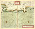
 Pascaart van de Noort zee (NYPL b13908778-1619022).jpg 5,528 × 4,567; 6.59 MB
-
 Pascaart van de Noort zee (NYPL b13908778-1619022).tiff 7,230 × 5,428; 112.28 MB
-
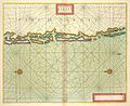
 Pas-caart van de Oost zee (NYPL b13908778-1619023).jpg 5,586 × 4,607; 6.73 MB
-
 Pas-caart van de Oost zee (NYPL b13908778-1619023).tiff 7,230 × 5,428; 112.28 MB
-
 Pascaarte van de Zuyder-zee (NYPL b13908778-1619024).jpg 5,280 × 4,440; 6.88 MB
-
 Pascaarte van de Zuyder-zee (NYPL b13908778-1619024).tiff 7,230 × 5,428; 112.28 MB
-
 Pascaart van de Noord Zee, van Texel tot de Hoofden (NYPL b13908778-1619025).jpg 5,508 × 4,554; 7.01 MB
-
 Cust van Hollant tusschen de Maes ende Texel (NYPL b13908778-1619026).jpg 5,397 × 4,440; 6.82 MB
-
-

-

-

-

-

-

-
 Het Canaal tusschen Engeland en Vrancrijck (NYPL b13908778-1619032).jpg 5,550 × 4,560; 7.02 MB
-

-
 Paskaarte om achter Yrlandt om te zeylen, van Hitlandt tot aen Heyssat (NYPL b13908778-1619033).tiff 7,230 × 5,428; 112.28 MB
-
 Paskaert van't in comen van't Canaal (NYPL b13908778-1619034).jpg 5,460 × 4,518; 6.36 MB
-
 Paskaert van't in comen van't Canaal (NYPL b13908778-1619034).tiff 7,230 × 5,428; 112.28 MB
-
-

-

-
 Paskaerte van't westelijckste der Middelandsche Zee (NYPL b13908778-1619037).jpg 5,358 × 4,290; 6.17 MB
-
 Paskaerte van't westelijckste der Middelandsche Zee (NYPL b13908778-1619037).tiff 7,230 × 5,428; 112.28 MB
-
 Paskaerte van't oostelijckste der Middelandsche Zee (NYPL b13908778-1619038).jpg 5,280 × 4,200; 6.09 MB
-

-

-

-

-

-

-
-

-

-
 Noordtoost cust van Asia, van Japan tot Nova Zemla (NYPL b13908778-1619046).jpg 5,472 × 4,632; 6.33 MB
-

-

-

-

-

-

-

-

-

-

-

-
 Pascaerte van Westindien, de vaste kusten en de Eylanden (NYPL b13908778-1619053).jpg 5,463 × 4,613; 6.88 MB
-
 Pascaerte van Westindien, de vaste kusten en de Eylanden (NYPL b13908778-1619053).tiff 7,230 × 5,428; 112.28 MB
-
 Pascaert van de Caribes Eylanden (NYPL b13908778-1619054).jpg 5,430 × 4,584; 5.79 MB
-
 Pascaert van de Caribes Eylanden (NYPL b13908778-1619054).tiff 7,230 × 5,428; 112.28 MB
-
 Paskaart van Brazil van Rio de los Amazones tot Rio de la Plata (NYPL b13908778-1619055).jpg 5,478 × 4,644; 6.04 MB
-
 Paskaart van Brazil van Rio de los Amazones tot Rio de la Plata (NYPL b13908778-1619055).tiff 7,230 × 5,428; 112.28 MB
-

-
-
 Pascaerte van Nova Hispania, Chili, Peru, en Gvatimala (NYPL b13908778-1619057).jpg 5,412 × 4,632; 6.63 MB
-
 Pascaerte van Nova Hispania, Chili, Peru, en Gvatimala (NYPL b13908778-1619057).tiff 7,230 × 5,428; 112.28 MB
-
 Paskaerte van Nova Granada en t'Eylandt California (NYPL b13908778-1619058).jpg 5,448 × 4,644; 5.94 MB
-
 Paskaerte van Nova Granada en t'Eylandt California (NYPL b13908778-1619058).tiff 7,230 × 5,428; 112.28 MB
-

-
 Pascaerte vande Zvyd-zee tussche California, en Ilhas de Ladrones (NYPL b13908778-1619018).tiff 7,230 × 5,428; 112.28 MB
-
 De zee-atlas ofte water-wereld (title page) (NYPL b13908780-ps map 183).jpg 4,072 × 4,072; 4.7 MB
-
 The Sea-Atlas (NYPL b13909432-1640702).jpg 4,537 × 6,998; 5.25 MB
-

-
 The Sea-Atlas (NYPL b13909432-1640704).jpg 3,562 × 5,670; 6.03 MB
-
 The Sea-Atlas (NYPL b13909432-1640706).jpg 3,524 × 5,470; 5.82 MB
-
 The Sea-Atlas (NYPL b13909432-1640707).jpg 3,558 × 5,524; 5.59 MB
-
 The Sea-Atlas (NYPL b13909432-1640708).jpg 3,585 × 5,601; 5.82 MB
-
 The Sea-Atlas (NYPL b13909432-1640709).jpg 3,494 × 5,544; 5.9 MB
-
 The Sea-Atlas (NYPL b13909432-1640710).jpg 3,492 × 5,520; 5.13 MB
-
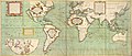
 A new mapp of the world (NYPL b13909432-1640711).jpg 5,964 × 4,823; 9.33 MB
-
 A new mapp of the world (NYPL b13909432-1640711).tiff 7,230 × 5,428; 112.28 MB
-
 A new and correct Mapp of the WORLD (NYPL b13909432-1640712).jpg 6,939 × 4,236; 8.53 MB
-
-

-

-

-

-

-

-
 A chart of the WHITE SEA with the River Dwina (NYPL b13909432-1640715).jpg 5,811 × 4,726; 6.14 MB
-

-

-
 The Chart of FINMARCK from Sanien to North-Kyn or North point (NYPL b13909432-1640718).jpg 5,839 × 4,776; 6.76 MB
-
 The Chart of FINMARCK from Dronten to Tromsound (NYPL b13909432-1640719).jpg 5,787 × 4,767; 6.75 MB
-
-
 The chart of the Leeth of BERGEN from Schuytenes to Bergen (NYPL b13909432-1640722).jpg 5,796 × 4,728; 6.16 MB
-
 The coast of NORWAY; between the Naze and Schuytenes (NYPL b13909432-1640723).jpg 5,789 × 4,769; 6.73 MB
-

-
 A chart of the BELT and SOUND (NYPL b13909432-1640725).jpg 6,690 × 3,838; 7.17 MB
-
 A chart of the EAST-SEA (NYPL b13909432-1640726).jpg 8,880 × 4,944; 7.5 MB
-

-
 A chart of PRUSSIA and Coerland from Rygshead to Der Winda (NYPL b13909432-1640728).jpg 5,829 × 4,792; 6.57 MB
-

-

-
 A chart of coast SWEDEN from Oeland to Stockholm (NYPL b13909432-1640731).jpg 5,831 × 4,776; 6.65 MB
.jpg)
.jpg)
.jpg)
.jpg)
.jpg)
.jpg)
.jpg)
.jpg)
_(NYPL_b13014516-478102).jpg)
.jpg)
.jpg)
.jpg)
.jpg)
_(NYPL_b13663520-1510810).jpg)
.jpg)
_(NYPL_b13663520-1510813).jpg)
.jpg)
.jpg)
_(NYPL_b13663520-1510833).jpg)
.jpg)
_(NYPL_b13663520-1510835).jpg)
;_San_Francisco_Bay_and_vicinity_(inset)_(NYPL_b13663520-1510822).jpg)
;_Map_of_the_Island_of_Jamaica_(inset);_Map_of_the_Bermuda_Islands_(inset);_Map_of_the_Panama_Railroad_(NYPL_b13663520-1510823).jpg)
_(NYPL_b13663520-1510824).jpg)
,_Venezuela,_and_Guiana;_Map_of_Peru_and_Equadorv;_Map_of_the_Argentine_Confederation_(NYPL_b13663520-1510825).jpg)
;_Harbor_of_Bahia_(inset);_Map_of_Chili;_Island_of_Juan_Fernandez_(inset)_(NYPL_b13663520-1510826).jpg)
.jpg)
.jpg)
.jpg)
;_Island_of_Corsica_(inset)_(NYPL_b13663520-1510829).jpg)
_(NYPL_b13663520-1510829).jpg)
_(cropped).jpg)
.jpg)
;_Ireland_in_provinces_and_counties_(NYPL_b13663520-1510831)_(cropped).jpg)
;_Ireland_in_provinces_and_counties_(NYPL_b13663520-1510831).jpg)
_(NYPL_b13663520-1510857).jpg)
_(NYPL_b13663520-1510858).jpg)
_(NYPL_b13663520-1510859).jpg)
_(NYPL_b13663520-1510860).jpg)
.jpg)
.jpg)
.jpg)
.jpg)
.jpg)
.jpg)
.jpg)
.jpg)
.jpg)
.jpg)
_(NYPL_b13908778-1619019).jpg)
.jpg)
.jpg)
.jpg)
.jpg)
.jpg)
.jpg)
.jpg)
.jpg)
.jpg)
.jpg)
.jpg)
.jpg)
.jpg)
.jpg)
.jpg)
.jpg)
.jpg)
.jpg)
.jpg)
.jpg)
.jpg)
.jpg)
.jpg)
.jpg)
.jpg)
.jpg)
.jpg)
.jpg)
.jpg)
.jpg)
.jpg)
.jpg)
.jpg)
.jpg)
.jpg)
.jpg)
.jpg)
.jpg)
.jpg)
_(NYPL_b13908780-ps_map_183).jpg)
.jpg)
.jpg)
.jpg)
.jpg)
.jpg)
.jpg)
.jpg)
.jpg)
.jpg)
.jpg)
.jpg)
.jpg)
.jpg)
.jpg)
.jpg)
.jpg)
.jpg)
.jpg)
.jpg)
.jpg)
.jpg)
.jpg)
.jpg)
.jpg)
.jpg)
.jpg)
.jpg)
.jpg)
.jpg)
.jpg)
.jpg)