Category:Maps of the history of Greenland
Jump to navigation
Jump to search
Subcategories
This category has only the following subcategory.
Media in category "Maps of the history of Greenland"
The following 16 files are in this category, out of 16 total.
-
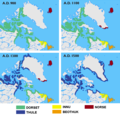
Arctic cultures 900-1500 (no caption).png 259 × 917; 209 KB
-
Arctic cultures 900-1500 (square).png 527 × 510; 223 KB
-
Arctic cultures 900-1500.png 259 × 989; 251 KB
-
Carte des explorations du Groenland-Expo coloniale 1931.jpg 5,045 × 6,358; 4.84 MB
-
Denmark-Norway in 1780.PNG 949 × 926; 21 KB
-
Denmark-Norway in 1780.svg 10,495 × 7,945; 319 KB
-
EricTheRedsLand.gif 271 × 470; 44 KB
-
EricTheRedsLand.svg 1,181 × 1,669; 813 KB
-
North Greenland in 1815.svg 450 × 456; 816 KB
-
Norwegian territorial claims in E Greenland 1931 - 1933.png 307 × 599; 25 KB
-
Ostsiedlung.png 540 × 720; 54 KB
-
South Greenland in 1815.svg 450 × 456; 816 KB
-
Vantahverfi Norse Greenland.jpg 768 × 724; 173 KB
-
Viking expansion.png 507 × 310; 109 KB
-
Western-settlement-eng.png 638 × 443; 158 KB


