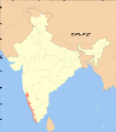
Category:Maps of the Malabar Coast
Jump to navigation
Jump to search
Subcategories
This category has only the following subcategory.
O
Media in category "Maps of the Malabar Coast"
The following 6 files are in this category, out of 6 total.
-
1909 Map of Malabar.jpg 2,560 × 1,920; 587 KB
-
A large draught of the MALLABAR COAST from bassalore to cape comaroone NYPL1640646.tiff 7,230 × 5,428; 112.28 MB
-
India Malabar Coast locator map.svg 1,639 × 1,852; 795 KB
-
Indo-Roman trade.jpg 2,499 × 1,413; 967 KB
-
Malabar District Map.jpg 3,402 × 5,444; 2.46 MB


