Category:Maps of the Holy Roman Empire in the 14th century
Jump to navigation
Jump to search
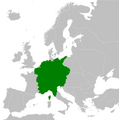
English: This category is about the subject of the Template:Country data Holy Roman Empire 1301-1400 CE: History maps showing all or a substantial part of the territory of the Holy Roman Empire as it was in the 14th century.
Contemporary old maps belong into: Category:14th-century maps of the Holy Roman Empire and its subcategories.
Contemporary old maps belong into: Category:14th-century maps of the Holy Roman Empire and its subcategories.
Subcategories
This category has the following 8 subcategories, out of 8 total.
B
G
I
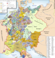
Media in category "Maps of the Holy Roman Empire in the 14th century"
The following 12 files are in this category, out of 12 total.
-

-
 C. 1350 Holy Roman Empire (Northern).jpg 3,789 × 2,993; 7.02 MB
-
 C. 1378 Central Europe.jpg 1,809 × 1,407; 3.06 MB
-
 C. 1378 Holy Roman Empire (Northwestern).jpg 1,250 × 1,194; 1.76 MB
-
 C. 1378 Holy Roman Empire (Southern).jpg 2,020 × 1,401; 2.7 MB
-
 C. 1492 Germany (1273-1492).jpg 3,879 × 3,031; 6.3 MB
-
 Germany from Rudolf von Habsburg to Maximilian I, 1275–1495 (Spruner, 1854).jpg 6,226 × 5,418; 6.93 MB
-
 Holy Roman Empire 1378.png 4,361 × 4,399; 1.15 MB
-
 Holy Roman Empire at the Golden Bull of 1356.png 4,872 × 4,672; 6.36 MB
-
 HRR 1400.png 3,715 × 3,966; 3.23 MB
-
 The Golden Bull of 1356.svg 1,559 × 1,495; 7.24 MB
-
 Священная Римская Империя-1400.jpg 2,079 × 1,919; 2.31 MB

.jpg)

.jpg)
.jpg)
.jpg)
.jpg)


