Category:Maps of protected areas of Canada
Jump to navigation
Jump to search
Countries of the Americas: Brazil · Canada · Colombia · Costa Rica · Ecuador · Peru · United States of America · Uruguay
Subcategories
This category has only the following subcategory.
N
Media in category "Maps of protected areas of Canada"
The following 40 files are in this category, out of 40 total.
-
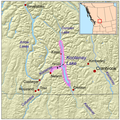 Kootenaylakemap.png 1,000 × 1,000; 972 KB
-
 Alonsa Wildlife Management Area boundaries.jpg 344 × 586; 45 KB
-
 Bowie Seamount Marine Protected Area.jpg 439 × 380; 14 KB
-
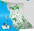 BC parks.png 724 × 661; 254 KB
-
 Bwca map.png 1,000 × 781; 311 KB
-
 Canadian Rocky Mountain parks map hu.svg 408 × 424; 176 KB
-
 Canadian Rocky Moutain parks map es.svg 408 × 424; 176 KB
-
 Canadian Rocky Moutain parks map He.svg 408 × 424; 248 KB
-
 Canadian Rocky Moutain parks map hr.svg 408 × 424; 176 KB
-
 Canadian Rocky Moutain parks map-fr.svg 408 × 424; 176 KB
-
 Canadian Rocky Moutain parks map.svg 408 × 424; 176 KB
-
 Cap Tourmente map-fr.svg 949 × 684; 328 KB
-
 Carte - Parc national des Monts-Valin.png 552 × 477; 218 KB
-
 Carte du parc national des Monts-Valin.png 1,618 × 1,420; 1.96 MB
-
 Carte Parc des îles de Boucherville.svg 1,165 × 1,212; 98 KB
-
 Carte Parc national des Monts-Valin.png 1,024 × 1,024; 1.11 MB
-
 Collinson Point Provincial Park.JPG 617 × 515; 38 KB
-
 Fort Creek map.JPG 3,264 × 2,448; 3.61 MB
-
 Fort Creek trail map.JPG 3,264 × 2,448; 3.72 MB
-
 Fundy National Park topographic map-fr.svg 1,043 × 1,076; 5.36 MB
-
 Fundy osm3D.png 826 × 516; 409 KB
-
 Lava Forks Provincial Park topo.png 467 × 450; 103 KB
-
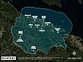 MABR map.jpg 990 × 743; 266 KB
-
 Map Cap tourmente.svg 1,548 × 817; 820 KB
-
 Moncton & Fundy National Park.jpg 879 × 738; 661 KB
-
 Mont-Saint-Bruno national park map.svg 1,311 × 1,140; 1.12 MB
-
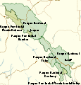
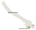
 Northern Parks overview Map.jpg 1,140 × 890; 169 KB
-
 Parc marin Saguenay en.svg 1,539 × 976; 699 KB
-
 Parc marin Saguenay fr.svg 1,539 × 976; 699 KB
-
 Parc national des Monts-Valin - Unites physiographiques.png 442 × 361; 10 KB
-
 Pete's Dam Park - panoramio.jpg 3,744 × 2,808; 2.01 MB
-
 Pete's Dam Park Legend - panoramio.jpg 3,744 × 2,808; 2 MB
-
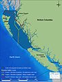 Proposed tanker routes and tanker prohibition zone.jpg 2,424 × 3,186; 2.74 MB
-
 Protected areas of New Brunswick map-blank.svg 2,237 × 2,199; 2.77 MB
-
 Protected areas of New Brunswick topographic map-blank.svg 2,237 × 2,199; 3.01 MB
-
 Reserve aquatique vallee sainte marguerite.png 1,920 × 1,080; 770 KB
-
 Réserve aquatique de l'Estuaire-de-la-Rivière-Bonaventure fr.svg 1,203 × 902; 244 KB
-
 Réserve aquatique de la Vallée-de-la-Rivière-Sainte-Marguerite.svg 512 × 340; 2.95 MB
-
 Réserve écologique René Babel.png 358 × 396; 253 KB
-
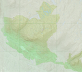
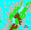
 Tatshenshini-Alsek area Canada BC.png 502 × 377; 29 KB


