Category:Maps of Tampere
Jump to navigation
Jump to search
English: Maps of the city of Tampere, Finland
Suomi: Tampereen kaupungin karttoja
Subcategories
This category has the following 4 subcategories, out of 4 total.
O
- Old maps of Tampere (4 F)
T
- Tram maps of Tampere (6 F)
- Travel maps of Tampere (1 F)
Media in category "Maps of Tampere"
The following 25 files are in this category, out of 25 total.
-
 Aitolahti.sijainti.svg 1,750 × 2,950; 1.14 MB
-
 Hervanta-1.gif 2,172 × 2,628; 1,010 KB
-
 Hervanta-2.gif 3,256 × 2,190; 1.21 MB
-
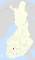
 Location of Tampere in Finland.png 230 × 400; 14 KB
-
 MapTampere-1941-2824.jpg 12,851 × 10,673; 17.55 MB
-
 Pirkanmaa Tampere 2011 clean.svg 384 × 488; 12 KB
-
 Pirkanmaa Tampere 2021 clean.svg 1,118 × 1,153; 15 KB
-
 Pirkkala1921.gif 499 × 416; 8 KB
-
 Poloha Tampere.png 230 × 400; 19 KB
-
 Tampere dot.png 1,804 × 3,002; 284 KB
-
 Tampere Finland street map.svg 5,783 × 5,501; 11.2 MB
-
 Tampere Karte2.PNG 887 × 523; 34 KB
-
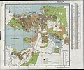
 Tampere Major Districts.png 840 × 980; 176 KB
-
 Tampere sijainti Suomi.svg 1,750 × 2,950; 703 KB
-
 Tampere.Map.png 1,382 × 934; 243 KB
-
 Tampere.Map.svg 1,052 × 744; 205 KB
-
 Tampere.sijainti.suomi.2007.svg 1,850 × 3,220; 269 KB
-
 Tampere.sijainti.suomi.2008.svg 1,850 × 3,220; 269 KB
-
 Tampere1877-1929.gif 583 × 874; 9 KB
-
 Tampere1937-50.gif 703 × 435; 11 KB
-
 Tampere1966-90s.gif 648 × 936; 15 KB
-
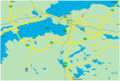
 Tampereen kaupunkiseudun kartta 2017.jpg 606 × 635; 47 KB
-
 Tampereen seurakunnat.svg 200 × 300; 24 KB
-
 Tampereen taistelu.jpg 8,959 × 6,380; 9.81 MB
-
 Tampereen toinen kehätie.png 1,642 × 501; 944 KB


