Category:Maps of Pará
Jump to navigation
Jump to search
States of Brazil: Acre · Alagoas · Amapá · Amazonas · Bahia · Ceará · Espírito Santo · Goiás · Maranhão · Mato Grosso · Mato Grosso do Sul · Minas Gerais · Pará · Paraíba · Paraná · Pernambuco · Piauí · Rio de Janeiro · Rio Grande do Norte · Rio Grande do Sul · Rondônia · Roraima · Santa Catarina · São Paulo · Sergipe · Tocantins · Distrito Federal
Wikimedia category | |||||
| Upload media | |||||
| Instance of | |||||
|---|---|---|---|---|---|
| Category combines topics | |||||
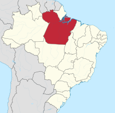
| Pará | |||||
state in the North Region of Brazil | |||||
| Instance of | |||||
| Part of | |||||
| Location | Brazil | ||||
| Capital | |||||
| Legislative body | |||||
| Executive body | |||||
| Anthem |
| ||||
| Head of government |
| ||||
| Inception |
| ||||
| Population |
| ||||
| Area |
| ||||
| Elevation above sea level |
| ||||
| Replaces |
| ||||
| Replaced by |
| ||||
| Electorate |
| ||||
| official website | |||||
 | |||||
Subcategories
This category has the following 8 subcategories, out of 8 total.
Media in category "Maps of Pará"
The following 21 files are in this category, out of 21 total.
-
Ananindeua mapa.JPG 653 × 824; 68 KB
-
Belém- expansão urbana.jpg 1,755 × 1,241; 1.04 MB
-
Curso d'Água Principal Rio Trombetas.jpg 766 × 721; 116 KB
-
Códigos Pfafstetter 4 Maiores Rio Trombetas.jpg 726 × 779; 89 KB
-
Códigos Pfafstetter Interbacias Rio Trombetas.jpg 681 × 754; 103 KB
-
Códigos Pfafstetter Nivel 4 Trombetas.JPG 703 × 752; 108 KB
-
Estado-do-Para-PA-Mapa-Escolar-IBGE-Brasil.pdf 1,239 × 1,752; 5.52 MB
-
Ffcr-mapa do para idh.png 2,000 × 1,934; 636 KB
-
Map-benevides.jpg 1,143 × 836; 98 KB
-
Mapa da Região Metropolitana de Belém e área de inlufência.jpg 1,755 × 1,241; 1.08 MB
-
Mapa da rota e naufrágio do Capitão Ribeiro.jpg 1,387 × 823; 197 KB
-
Mapa de Ig miri DISTRITOSj.jpg 5,875 × 3,819; 1,020 KB
-
Mapa de Paragominas.png 14,042 × 9,934; 4.99 MB
-
Mapa Geológico Carajás.png 602 × 705; 239 KB
-
Provincia Eclesiástica de Belém do Pará.jpg 3,198 × 2,328; 1.9 MB
-
Provincia Eclesiástica de Santarém (Brasil).jpg 3,175 × 2,048; 1.63 MB
-
ProvinciaEclesiasticaBelemdoPara.jpg 3,198 × 2,328; 1.9 MB
-
Províncias Tectônicas Carajás.png 602 × 595; 310 KB
-
Railways of Metropolitan Region of Belém.jpg 783 × 548; 124 KB
-
RMB - Logística.jpg 1,040 × 606; 176 KB


