Category:Maps of Ludwigshafen am Rhein
Jump to navigation
Jump to search
Urban districts (cities): Frankenthal · Kaiserslautern · Coblenz · Landau · Ludwigshafen · Mainz · Neustadt an der Weinstrasse · Speyer · Trier · Zweibrücken
Wikimedia category | |||||
| Upload media | |||||
| Instance of | |||||
|---|---|---|---|---|---|
| Category combines topics | |||||
| Ludwigshafen | |||||
city in Rhineland-Palatinate, Germany | |||||
| Pronunciation audio | |||||
| Instance of |
| ||||
| Location | Rhineland-Palatinate, Germany | ||||
| Located in or next to body of water | |||||
| Head of government |
| ||||
| Population |
| ||||
| Area |
| ||||
| Elevation above sea level |
| ||||
| official website | |||||
 | |||||
Subcategories
This category has only the following subcategory.
Media in category "Maps of Ludwigshafen am Rhein"
The following 54 files are in this category, out of 54 total.
-
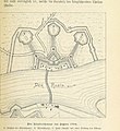
Hemshof und Umgebung 19. Jahrhundert.jpg 705 × 572; 200 KB
-
Hemshof.png 371 × 401; 4 KB
-
Locator map LU in Rhineland-Palatinate.svg 708 × 913; 627 KB
-
LU in Rheinland-Pfalz.svg 574 × 744; 133 KB
-
LU-BASF.png 676 × 697; 10 KB
-
LU-Edigheim.png 676 × 695; 10 KB
-
LU-Friesenheim.png 664 × 693; 10 KB
-
LU-Gartenstadt.png 661 × 692; 10 KB
-
LU-Hemshof.png 664 × 693; 10 KB
-
LU-Maudach.png 663 × 695; 10 KB
-
LU-Mundenheim.png 663 × 693; 10 KB
-
LU-Nord.png 665 × 693; 10 KB
-
LU-Nordliche-Innenstadt.png 665 × 693; 17 KB
-
LU-Oggersheim.png 661 × 693; 10 KB
-
LU-Oppau-ganz.png 663 × 693; 10 KB
-
LU-Oppau.png 662 × 693; 10 KB
-
LU-Pfingstweide.png 660 × 694; 10 KB
-
LU-Rheingoenheim.png 662 × 694; 10 KB
-
LU-Ruchheim.png 665 × 693; 10 KB
-
LU-Stadtmitte.png 662 × 694; 10 KB
-
LU-Sued.png 663 × 693; 10 KB
-
LU-Suedliche-Innenstadt.png 663 × 693; 17 KB
-
LU-West.png 660 × 693; 10 KB
-
Ludwigshafen am Rhein in Germany.png 188 × 235; 5 KB
-
Ludwigshafen BASF.png 789 × 868; 18 KB
-
Ludwigshafen Edigheim.png 789 × 868; 18 KB
-
Ludwigshafen Friesenheim.png 789 × 868; 18 KB
-
Ludwigshafen Gartenstadt.png 789 × 868; 18 KB
-
Ludwigshafen Hemshof.png 789 × 868; 18 KB
-
Ludwigshafen Maudach.png 789 × 868; 18 KB
-
Ludwigshafen Maudacher Bruch.png 789 × 868; 18 KB
-
Ludwigshafen Mitte.png 789 × 868; 18 KB
-
Ludwigshafen Mundenheim.png 789 × 868; 18 KB
-
Ludwigshafen Oggersheim.png 789 × 868; 16 KB
-
Ludwigshafen Oppau.png 789 × 868; 18 KB
-
Ludwigshafen Parkinsel.png 789 × 868; 17 KB
-
Ludwigshafen Rheingoenheim.png 789 × 868; 18 KB
-
Ludwigshafen Ruchheim.png 789 × 868; 18 KB
-
Ludwigshafen Sued.png 789 × 868; 18 KB
-
Ludwigshafen West.png 789 × 868; 18 KB
-
Ludwigshafen-West.png 1,270 × 1,384; 856 KB
-
Ludwigshafen-West1.png 1,270 × 1,384; 857 KB
-
Ludwigshafen-West2.png 1,270 × 1,384; 842 KB
-
Map de Ludwigshafen.PNG 188 × 235; 3 KB
-
Maudach.png 285 × 304; 25 KB
-
Mundenheim.png 372 × 412; 4 KB
-
OAN Grenzen und Orte 17982d.png 1,099 × 1,297; 150 KB
-
Oggersheim.png 372 × 412; 4 KB
-
Rheingoenheim.png 372 × 401; 4 KB
-
Ruchheim.png 372 × 412; 4 KB
-
StadtLudwigshafen.png 452 × 414; 48 KB


