
Category:Maps of Lee County, Alabama
Counties of Alabama: Autauga · Baldwin · Barbour · Bibb · Blount · Bullock · Butler · Calhoun · Chambers · Cherokee · Chilton · Choctaw · Clarke · Clay · Cleburne · Coffee · Colbert · Conecuh · Coosa · Covington · Crenshaw · Cullman · Dale · Dallas · DeKalb · Elmore · Escambia · Etowah · Fayette · Franklin · Geneva · Greene · Hale · Henry · Houston · Jackson · Jefferson · Lamar · Lauderdale · Lawrence · Lee · Limestone · Lowndes · Macon · Madison · Marengo · Marion · Marshall · Mobile · Monroe · Montgomery · Morgan · Perry · Pickens · Pike · Randolph · Russell · Shelby · St. Clair · Sumter · Talladega · Tallapoosa · Tuscaloosa · Walker · Washington · Wilcox · Winston
Wikimedia category | |||||
| Upload media | |||||
| Instance of | |||||
|---|---|---|---|---|---|
| Category combines topics | |||||
| Lee County | |||||
county in Alabama, United States .jpg)  | |||||
| Instance of | |||||
| Named after | |||||
| Location | Alabama | ||||
| Capital | |||||
| Inception |
| ||||
| Population |
| ||||
| Area |
| ||||
| Different from | |||||
| official website | |||||
 | |||||
Subcategories
This category has the following 2 subcategories, out of 2 total.
Media in category "Maps of Lee County, Alabama"
The following 26 files are in this category, out of 26 total.
-
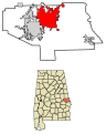
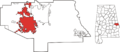 AL-Auburn-location-in-Lee-County.png 1,299 × 568; 76 KB
-
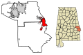
 AL-Smiths-Station-location-in-Lee-County.png 1,299 × 568; 71 KB
-
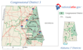 AL03 110.png 633 × 379; 45 KB
-
 ALMap-doton-Opelika.png 193 × 300; 14 KB
-
 ALMap-doton-Waverly.PNG 193 × 300; 14 KB
-
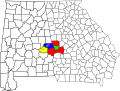
 Auburn-Opelika, Alabama Metropolitan Statistical Area.svg 558 × 887; 129 KB
-

-
 Columbus-Auburn-Opelika, Georgia-Alabama Combined Statistical Area.svg 1,186 × 895; 313 KB
-
 Lee County AL formation.png 413 × 455; 15 KB
-
 Lee County AL Political Map.png 653 × 354; 32 KB
-

-

-

-

-

-
-

-

-

-

-

-

-
-
 Lee County Schools attendance zones.png 500 × 292; 35 KB
-
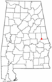
 Map of Alabama highlighting Lee County.svg 644 × 1,018; 77 KB
-
 WaverlyMap.GIF 800 × 350; 28 KB


