Category:Maps of Landkreis Ansbach
Jump to navigation
Jump to search
Urban districts (cities): Amberg · Ansbach · Aschaffenburg · Augsburg · Bamberg · Bayreuth · Coburg · Erlangen · Fürth · Hof · Ingolstadt · Kaufbeuren · Kempten · Landshut · Memmingen · Munich · Nuremberg · Passau · Regensburg · Rosenheim · Schweinfurt · Straubing · Weiden in der Oberpfalz · Würzburg
Deutsch: Karten und Pläne des Landkreises Ansbach.
Wikimedia category | |||||
| Upload media | |||||
| Instance of | |||||
|---|---|---|---|---|---|
| Category combines topics | |||||
| Ansbach | |||||
district in Bavaria, Germany   .svg) | |||||
| Instance of |
| ||||
| Location | Middle Franconia, Bavaria, Germany | ||||
| Capital | |||||
| Head of government |
| ||||
| Inception |
| ||||
| Population |
| ||||
| Area |
| ||||
| Elevation above sea level |
| ||||
| official website | |||||
 | |||||
Subcategories
This category has the following 27 subcategories, out of 27 total.
!
B
- Maps of Burgoberbach (1 F)
- Maps of Burk (2 F)
C
- Maps of Colmberg (2 F)
D
- Maps of Dietenhofen (2 F)
E
H
- Maps of Heilsbronn (2 F)
- Maps of Herrieden (2 F)
L
- Maps of Lehrberg (2 F)
M
- Maps of Mitteleschenbach (2 F)
N
O
- Maps of Oberdachstetten (2 F)
- Maps of Ohrenbach (2 F)
P
- Maps of Petersaurach (3 F)
R
S
- Maps of Sachsen bei Ansbach (2 F)
- Maps of Steinsfeld (2 F)
U
- Maps of Unterschwaningen (2 F)
W
- Maps of Wassertrüdingen (2 F)
- Maps of Weihenzell (3 F)
- Maps of Windelsbach (2 F)
- Maps of Wolframs-Eschenbach (2 F)
Media in category "Maps of Landkreis Ansbach"
The following 8 files are in this category, out of 8 total.
-
 1973 Rothenburg ob der Tauber 09.JPG 1,704 × 2,272; 802 KB
-
 RothenburgObDerTauberAltstadt2022OSM.png 3,629 × 3,410; 5.55 MB
-
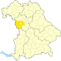 AN (Lkr) in Bayern.svg 1,227 × 1,236; 311 KB
-
 Karte - Ansbach und Umgebung - um 1800.jpg 9,765 × 11,154; 4 MB
-
 Lage des Landkreises Ansbach in Deutschland.png 197 × 235; 3 KB
-
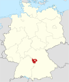
 Locator map AN in Bavaria.svg 867 × 855; 1,000 KB
-
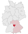
 Locator map AN in Germany.svg 1,075 × 1,273; 581 KB
-
 Zusammensetzung des Landkreises Ansbach.png 1,027 × 957; 89 KB


_in_Bayern.svg)


