Category:Maps of Holstein
Jump to navigation
Jump to search
Subcategories
This category has the following 2 subcategories, out of 2 total.
Media in category "Maps of Holstein"
The following 18 files are in this category, out of 18 total.
-

-

-
 Grafschaften Holstein Ratzeburg Schwerin Dannenberg Luechow 1250.png 700 × 796; 284 KB
-
 Północno-wschodnie Niemcy ok 1250.svg 700 × 796; 1.7 MB
-
 Herzogtum Sachsen Lauenburg 1400.PNG 349 × 343; 88 KB
-
 Duchy of Holstein 1789.svg 450 × 456; 928 KB
-
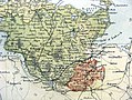
 Holstein1848.png 654 × 542; 23 KB
-
 Map-DB-Holstein.svg 1,793 × 1,571; 1.67 MB
-
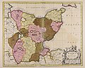
 Saxoniae Inferioris (Merian) b 001.jpg 3,701 × 3,089; 3.84 MB
-
 SleeswijkHolsteinLauenburg1848.png 361 × 418; 29 KB
-
 Meyer‘s Zeitungsatlas 106 – Holstein mit Lauenburg, Hamburg und Lübeck.jpg 7,243 × 6,070; 15.86 MB
-
 1866 Black Holstein.jpg 940 × 705; 327 KB
-
 Herzogtümer.png 2,000 × 2,395; 791 KB
-
 Karte Düppeler Schanzen im Deutsch-Dänischen Krieg.png 1,000 × 1,171; 315 KB
-
 Kort 2. Slesvigske Krig Militære begivenheder.png 1,861 × 2,228; 713 KB
-
 Hertugdømmerne.png 2,000 × 2,395; 800 KB
-

-
 Wagria quae est pars orientalis Holsatiae - CBT 5872910.jpg 5,853 × 4,749; 7.79 MB
.jpg)
.jpg)


_b_001.jpg)


.jpg)
