Category:Maps about the COVID-19 pandemic in Austria
Jump to navigation
Jump to search
Subcategories
This category has the following 2 subcategories, out of 2 total.
Media in category "Maps about the COVID-19 pandemic in Austria"
The following 12 files are in this category, out of 12 total.
-
 Austria COVID-19 cases per capita.svg 512 × 274; 94 KB
-
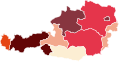
 Covid-19 - Austria Cases per 100k - 1403.svg 1,000 × 514; 23 KB
-
 Covid-19 - Austria Death toll per million.svg 1,000 × 514; 28 KB
-
COVID-19 Austria 7-day prevalence per capita (districts timeline).webm 1 min 53 s, 1,500 × 802; 3.02 MB
-
COVID-19 Austria cases per capita (districts timeline).webm 1 min 1 s, 1,000 × 534; 787 KB
-
 COVID-19 Austria cases per capita (last 14 days).svg 512 × 274; 97 KB
-
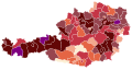 COVID-19 Austria Cases per District.svg 2,430 × 1,277; 55 KB
-
 COVID-19 Outbreak Cases in Austria.svg 1,250 × 643; 77 KB
-
 Covid-19 Outbreak in Austria - density.svg 585 × 300; 43 KB
-
 COVID-19 Schulschliessungen OOe Juli 2020.png 837 × 436; 62 KB
-
 COVID-Austria - per 100k - districts.svg 800 × 413; 835 KB
-
 CoViD19 Bezirke Österreich.svg 2,430 × 1,277; 61 KB


.svg)


