Category:Locator maps of Verwaltungsgemeinschaft Leinetal
Jump to navigation
Jump to search
Media in category "Locator maps of Verwaltungsgemeinschaft Leinetal"
The following 8 files are in this category, out of 8 total.
-
 Bodenrode-Westhausen in EIC.svg 1,149 × 1,140; 510 KB
-
 Geisleden in EIC.svg 1,149 × 1,140; 510 KB
-
 Glasehausen in EIC.svg 1,149 × 1,140; 578 KB
-
 Hohes Kreuz in EIC.svg 1,149 × 1,140; 578 KB
-
 Reinholterode in EIC.svg 1,149 × 1,140; 510 KB
-
 Steinbach in EIC.svg 1,149 × 1,140; 510 KB
-
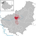
 Verwaltungsgemeinschaft Leinetal in EIC.svg 1,149 × 1,140; 510 KB
-
 Wingerode in EIC.svg 1,149 × 1,140; 510 KB


