Category:Locator maps of Ohio
Jump to navigation
Jump to search
States of the United States: Alabama · Alaska · Arizona · Arkansas · California · Colorado · Connecticut · Delaware · Florida · Georgia · Hawaii · Idaho · Illinois · Indiana · Iowa · Kansas · Kentucky · Louisiana · Maine · Maryland · Massachusetts · Michigan · Minnesota · Mississippi · Missouri · Montana · Nebraska · Nevada · New Hampshire · New Jersey · New Mexico · New York · North Carolina · North Dakota · Ohio · Oklahoma · Oregon · Pennsylvania · Rhode Island · South Carolina · South Dakota · Tennessee · Texas · Utah · Vermont · Virginia · Washington · West Virginia · Wisconsin · Wyoming – Washington, D.C.
insular area of the United States: American Samoa · Guam · Northern Mariana Islands · Puerto Rico · United States Virgin Islands – Baker Island · Howland Island · Jarvis Island · Johnston Atoll · Kingman Reef · Midway Atoll · Navassa Island · Palmyra Atoll · Wake Island
insular area of the United States: American Samoa · Guam · Northern Mariana Islands · Puerto Rico · United States Virgin Islands – Baker Island · Howland Island · Jarvis Island · Johnston Atoll · Kingman Reef · Midway Atoll · Navassa Island · Palmyra Atoll · Wake Island
Subcategories
This category has the following 9 subcategories, out of 9 total.
Media in category "Locator maps of Ohio"
The following 64 files are in this category, out of 64 total.
-
 2nd WV Cavalry and Ohio Counties for Recruits.JPG 550 × 608; 94 KB
-
 Findlay-tiffinCSA.PNG 215 × 193; 3 KB
-
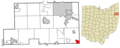
 Jefferson County Ohio incorporated and unincorporated areas Bloomingdale highlighted.png 2,067 × 1,837; 370 KB
-
 Jefferson County Ohio incorporated and unincorporated areas Brilliant highlighted.png 2,067 × 1,837; 370 KB
-
 Jefferson County Ohio incorporated and unincorporated areas Connorsville highlighted.png 2,067 × 1,837; 371 KB
-
 Jefferson County Ohio incorporated and unincorporated areas Dillonvale highlighted.png 2,067 × 1,837; 370 KB
-

-
 Jefferson County Ohio incorporated and unincorporated areas Empire highlighted.png 2,067 × 1,837; 370 KB
-
 Jefferson County Ohio incorporated and unincorporated areas Irondale highlighted.png 2,067 × 1,837; 370 KB
-

-

-
-
 Jefferson County Ohio incorporated and unincorporated areas Rayland highlighted.png 2,067 × 1,837; 370 KB
-
 Jefferson County Ohio incorporated and unincorporated areas Richmond highlighted.png 2,067 × 1,837; 370 KB
-
 Jefferson County Ohio incorporated and unincorporated areas Stratton highlighted.png 2,067 × 1,837; 370 KB
-
 Jefferson County Ohio incorporated and unincorporated areas Tiltonsville highlighted.png 2,067 × 1,837; 370 KB
-
 Jefferson County Ohio incorporated and unincorporated areas Toronto highlighted.png 2,067 × 1,837; 370 KB
-
 Jefferson County Ohio incorporated and unincorporated areas Wintersville highlighted.png 2,067 × 1,837; 371 KB
-
 Jefferson County Ohio incorporated and unincorporated areas Yorkville highlighted.png 2,067 × 1,837; 390 KB
-
 Mahoning County Ohio incorporated and unincorporated areas Craig Beach highlighted.png 2,742 × 1,093; 476 KB
-
 Mahoning County Ohio incorporated and unincorporated areas Lake Milton highlighted.png 2,742 × 1,093; 476 KB
-
 Mahoning County Ohio incorporated and unincorporated areas Lowellville highlighted.png 2,742 × 1,093; 476 KB
-
 Mahoning County Ohio incorporated and unincorporated areas Maple Ridge highlighted.png 2,742 × 1,093; 476 KB
-

-

-
 Mahoning County Ohio incorporated and unincorporated areas Petersburg highlighted.png 2,742 × 1,093; 475 KB
-
 Mahoning County Ohio incorporated and unincorporated areas Poland highlighted.png 2,742 × 1,093; 475 KB
-
 Mahoning County Ohio incorporated and unincorporated areas Woodworth highlighted.png 2,742 × 1,093; 476 KB
-
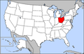 Map of USA highlighting Ohio.png 280 × 183; 35 KB
-
 Map of USA OH.svg 286 × 186; 167 KB
-
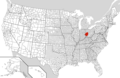 Miami Valley location.png 1,513 × 983; 182 KB
-
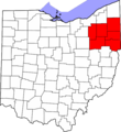
 Northeast Ohio counties map.PNG 557 × 599; 184 KB
-
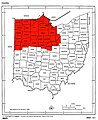 Northwest Ohio Counties Map.jpg 1,176 × 1,442; 198 KB
-
 Northwest Ohio Counties Map.png 1,176 × 1,442; 137 KB
-
 OAC-USA-states.png 841 × 580; 17 KB
-
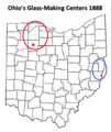
 Ohio Glass Making Centers 1888.jpg 550 × 633; 43 KB
-
 Ohio House 78 District.png 2,000 × 2,376; 558 KB
-
 OhioGlassMakingCenters1888BellaireFindlay.png 331 × 393; 46 KB
-
 OHMap-CSX8888.png 274 × 300; 11 KB
-
 Polymer Valley Map.png 500 × 544; 27 KB
-
 Schoenbrunnohio1772.png 486 × 683; 46 KB
-
 State of Ohio.png 2,560 × 1,585; 881 KB
-
-

-

-

-

-
-
-
-

-

-
-

-

-

-
 Trumbull County Ohio incorporated and unincorporated areas Mineral Ridge highlighted.png 1,529 × 1,328; 286 KB
-

-
-

-

-

-

-
 USA Names Ohio.png 5,895 × 4,049; 1.51 MB


