Category:Krishna district
Jump to navigation
Jump to search
district of Andhra Pradesh, India | |||||
| Upload media | |||||
| Instance of | |||||
|---|---|---|---|---|---|
| Location |
| ||||
| Capital | |||||
| Population |
| ||||
| Area |
| ||||
| official website | |||||
 | |||||
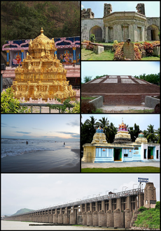
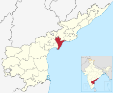
Krishna District (Telugu: కృష్ణా జిల్లా) is a district of India's Andhra Pradesh state. It is named after the Krishna River which flows through the district. It has a population of 4,187,841 of which 32.08% is urban (as of 2001). Machilipatnam is the administrative headquarters of the district. Vijayawada is the commercial center of the district. The district is bounded by the districts of Khammam to the north-west, West Godavari District to the north-east, the Bay of Bengal to the south-east, Guntur district to the southwest, and Nalgonda district to the west.
Subcategories
This category has the following 10 subcategories, out of 10 total.
A
Media in category "Krishna district"
The following 24 files are in this category, out of 24 total.
-
AP Village-Baggeswaram.jpg 180 × 216; 37 KB
-
Greenfields.jpg 4,160 × 3,120; 1.09 MB
-
Jaggayyapeta Cheruvu.jpg 4,160 × 3,120; 1.35 MB
-
Leather puppet gallery at handloom show Vijayawada oct 2019 10.jpg 3,120 × 4,208; 6.12 MB
-
Leather puppet gallery at handloom show Vijayawada oct 2019 11.jpg 3,000 × 4,000; 7.98 MB
-
Leather puppet gallery at handloom show Vijayawada oct 2019 12.jpg 4,000 × 3,000; 7.41 MB
-
Leather puppet gallery at handloom show Vijayawada oct 2019 13.jpg 4,000 × 3,000; 8.29 MB
-
Leather puppet gallery at handloom show Vijayawada oct 2019 14.jpg 3,000 × 4,000; 6.93 MB
-
Leather puppet gallery at handloom show Vijayawada oct 2019 15.jpg 3,000 × 4,000; 7.7 MB
-
Leather puppet gallery at handloom show Vijayawada oct 2019 16.jpg 3,000 × 4,000; 6.25 MB
-
Leather puppet gallery at handloom show Vijayawada oct 2019 17.jpg 4,000 × 3,000; 6.88 MB
-
Leather puppet gallery at handloom show Vijayawada oct 2019 2.jpg 3,120 × 4,208; 6.31 MB
-
Leather puppet gallery at handloom show Vijayawada oct 2019 3.jpg 4,208 × 3,120; 6.19 MB
-
Leather puppet gallery at handloom show Vijayawada oct 2019 4.jpg 4,000 × 3,000; 7.92 MB
-
Leather puppet gallery at handloom show Vijayawada oct 2019 5.jpg 3,000 × 4,000; 8.79 MB
-
Leather puppet gallery at handloom show Vijayawada oct 2019 6.jpg 4,208 × 3,120; 6.19 MB
-
Leather puppet gallery at handloom show Vijayawada oct 2019 7.jpg 4,208 × 3,120; 6.44 MB
-
Leather puppet gallery at handloom show Vijayawada oct 2019 8.jpg 3,120 × 4,208; 5.69 MB
-
Leather puppet gallery at handloom show Vijayawada oct 2019 9.jpg 3,120 × 4,208; 5.73 MB
-
Putta.jpg 4,160 × 3,120; 2.15 MB
-
Thotananda-modumudi.jpg 3,264 × 1,836; 2.45 MB


