
Category:Geology of Ontario
Provinces and territories of Canada: Alberta · British Columbia · Manitoba · New Brunswick · Newfoundland and Labrador · Nova Scotia · Ontario · Prince Edward Island · Quebec · Saskatchewan · Northwest Territories · Nunavut · Yukon
Wikimedia category | |||||
| Upload media | |||||
| Instance of | |||||
|---|---|---|---|---|---|
| |||||
Subcategories
This category has the following 46 subcategories, out of 46 total.
- Geology of the Niagara Gorge (13 F)
+
- Geological maps of Ontario (14 F)
A
B
C
D
E
F
G
H
I
L
- Lake Duluth (7 F)
M
- Lake Minong (1 F)
N
O
P
R
S
- Sudbury Breccia (13 F)
T
V
Media in category "Geology of Ontario"
The following 81 files are in this category, out of 81 total.
-
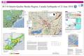 2010 Central Canada earthquake - USGS poster.pdf 5,400 × 3,600; 11.78 MB
-
 Ancient Asteroid Impact Debrisite in Thunder Bay (8031545102).jpg 2,400 × 1,801; 2.63 MB
-
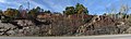
 Armstrong Rocks eroded by thousands of year of ice action.jpg 4,368 × 2,912; 6.83 MB
-

-

-

-

-

-

-

-

-

-
 CanadianShield.jpg 3,000 × 4,500; 8.24 MB
-

-

-

-
 Chippewa and Stanley Low Levels (Larsen 1987).jpg 1,287 × 961; 125 KB
-
 Notes on the geology of south-western Ontario (microform) (IA cihm 07752).pdf 1,156 × 1,364, 17 pages; 750 KB
-

-
 Deloro complex granite.jpg 11,216 × 3,377; 9.18 MB
-

-

-
 Faille de Cadillac.png 963 × 464; 393 KB
-

-

-
 Gold-quartz hydrothermal vein (Geraldton, Ontario, Canada) (17043100245).jpg 2,850 × 1,906; 2.4 MB
-
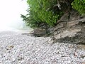
 Gros Cap bluffs.JPG 2,560 × 1,920; 809 KB
-
 KomatiiteCanada 682By512.jpg 682 × 512; 72 KB
-
 KomatiiteCanada.jpg 223 × 167; 18 KB
-
 Madocite (tourmaline-pyrite metamorphite), Madoc Ontario.jpg 3,008 × 2,000; 2.37 MB
-

-

-

-

-
 Mica Bay shore 11.JPG 2,448 × 3,264; 2.62 MB
-
 Mica Bay shore 12.JPG 3,264 × 2,448; 3.88 MB
-
 Mica Bay shore 3.JPG 3,264 × 2,448; 3.77 MB
-
 Mica Bay shore 4.JPG 3,264 × 2,448; 3.52 MB
-
 Mica Bay shore 5.JPG 3,264 × 2,448; 3.82 MB
-
 Mica Bay shore 7.JPG 3,264 × 2,448; 3.75 MB
-
 Mica Bay shore 8.JPG 3,264 × 2,448; 3.83 MB
-
 Mica Bay shore 9.JPG 3,264 × 2,448; 3.79 MB
-
 Nature's Art created by thousands of years of erosion by ice.jpg 4,368 × 2,912; 8.58 MB
-

-

-

-

-
 Ontario Paleoriver and the Bedford Shale.jpg 743 × 590; 93 KB
-

-

-

-
 Quartz outcrop at Armstrong Rocks Parry Sound.jpg 2,912 × 4,368; 6.24 MB
-
-

-

-

-

-

-
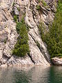
 Rocky bluff, Garden River.JPG 2,560 × 1,920; 805 KB
-
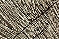
 Roots and slate.JPG 2,448 × 3,264; 2.74 MB
-
 Shoreline rocks near Jones Landing 1.JPG 3,264 × 2,448; 3.88 MB
-
 Shoreline rocks near Jones Landing 2.JPG 3,264 × 2,448; 3.71 MB
-
 Shoreline rocks near Jones Landing 3.JPG 2,448 × 3,264; 2.48 MB
-
 Shoreline rocks near Jones Landing 4.JPG 3,264 × 2,448; 3.72 MB
-
-
 Skeletal magnetite.JPG 3,456 × 2,304; 9.54 MB
-
 Skeletal olivine.JPG 3,456 × 2,304; 9.04 MB
-
 Slate formation at Mica Bay 1.JPG 3,264 × 2,448; 3.77 MB
-
 Slate formation at Mica Bay 2.JPG 3,264 × 2,448; 3.81 MB
-
 Slate formation at Mica Bay 3.JPG 3,264 × 2,448; 3.32 MB
-
 Slate formation at Mica Bay 4.JPG 3,264 × 2,448; 3.54 MB
-
 Slate formation at Mica Bay 5.JPG 3,264 × 2,448; 3.83 MB
-
 Slate formation at Mica Bay 6.JPG 3,264 × 2,448; 3.74 MB
-
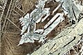
 Slate Islands Shattercone.JPG 1,728 × 2,304; 1.56 MB
-
 SplitConcretion KettlePointOntario.jpg 2,592 × 1,944; 1.01 MB
-
 Sudbury-basin-1917.png 588 × 481; 238 KB
-
 The Canadian field-naturalist (1931) (20334048619).jpg 1,856 × 1,436; 1.27 MB
-
 The Canadian field-naturalist (1931) (20334052869).jpg 1,858 × 1,342; 1.14 MB
-
 The Canadian field-naturalist (1931) (20494518986).jpg 1,854 × 1,340; 1.11 MB
-
 The Pleistocene of the Toronto region.jpg 9,199 × 7,884; 13.35 MB
-
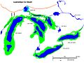
 USGS Lake Superior syncline.png 1,007 × 679; 603 KB
.jpg)

,_Porcupine_Mining_District,_east_of_Timmins,_Ontario,_Canada)_1_(15178961728).jpg)
,_Porcupine_Mining_District,_east_of_Timmins,_Ontario,_Canada)_2_(15365235032).jpg)
_10_(48263132911).jpg)
_14_(48263158886).jpg)
_24_(48263466726).jpg)
_25_(48263460626).jpg)
_38_(48270287716).jpg)
_40_(48270280136).jpg)
_(Helen_Iron-Formation,_Neoarchean,_2696-2749_Ma;_Sir_James_Pit,_Eleanor_Iron_Range,_Ontario,_Canada)_7_(48069973492).jpg)

_3_(47734650301).jpg)
_4_(33857443908).jpg)
_10_(33858614708).jpg)
.jpg)
_5_(47670458302).jpg)
_35_(47675607142).jpg)


_2_(46847449705).jpg)
_2_(32792412547).jpg)
_(17043100245).jpg)


,_Madoc_Ontario.jpg)
_20_(32817627707).jpg)
_(Gowganda_Formation,_Paleoproterozoic,_~2.3_Ga;_Route_6_outcrop,_north_of_Manitoulin_Island,_Ontario,_Canada)_2.jpg)
_(Gowganda_Formation,_Paleoproterozoic,_~2.3_Ga;_Route_6_outcrop,_north_of_Manitoulin_Island,_Ontario,_Canada)_3.jpg)
_(Gowganda_Formation,_Paleoproterozoic,_~2.3_Ga;_Route_6_outcrop,_north_of_Manitoulin_Island,_Ontario,_Canada)_4.jpg)


_BHL26576585.jpg)
_BHL26576601.jpg)


_3_(33938501728).jpg)
_7_(40841856863).jpg)
_8_(48069963493).jpg)

_2_(47708876131).jpg)
_1_(47722592811).jpg)
_2_(47722585821).jpg)
_(46806218155).jpg)
_1_(47722571651).jpg)
_2_(46806233715).jpg)


_3_(48069964952).jpg)


_(20334048619).jpg)
_(20334052869).jpg)
_(20494518986).jpg)

