Category:Geology of Nova Scotia
Jump to navigation
Jump to search
Provinces and territories of Canada: Alberta · British Columbia · Manitoba · New Brunswick · Newfoundland and Labrador · Nova Scotia · Ontario · Prince Edward Island · Quebec · Saskatchewan · Northwest Territories · Nunavut · Yukon
Wikimedia category | |||||
| Upload media | |||||
| Instance of | |||||
|---|---|---|---|---|---|
| Category combines topics | |||||
| Nova Scotia | |||||
province of Canada .jpg)    | |||||
| Instance of | |||||
| Named after | |||||
| Location | Canada | ||||
| Located in or next to body of water | |||||
| Capital | |||||
| Basic form of government |
| ||||
| Legislative body |
| ||||
| Executive body |
| ||||
| Official language | |||||
| Currency |
| ||||
| Head of state |
| ||||
| Head of government |
| ||||
| Inception |
| ||||
| Highest point |
| ||||
| Population |
| ||||
| Area |
| ||||
| Replaces |
| ||||
| Different from | |||||
| official website | |||||
 | |||||
Subcategories
This category has the following 36 subcategories, out of 36 total.
*
+
B
C
D
E
F
- Folds in Nova Scotia (1 F)
- Fundy Geological Museum (1 F)
G
H
J
- Joggins Fossil Cliffs (39 F)
L
M
O
P
- Palaeontology in Nova Scotia (2 F)
R
S
V
W
Media in category "Geology of Nova Scotia"
The following 90 files are in this category, out of 90 total.
-
 3D ancient ripples.JPG 3,456 × 2,304; 4.66 MB
-
 Angelwing burrow1.jpg 1,990 × 1,494; 1.71 MB
-
 Angelwing burrow2.jpg 1,949 × 1,461; 1.74 MB
-
 Balancing Rock.jpg 768 × 1,024; 126 KB
-
 Blue rock.JPG 2,816 × 2,112; 3.74 MB
-
 Caliche-red-mudrock.JPG 1,704 × 2,272; 1.96 MB
-
 Cape Breton HIghlands National Park Freshwater Lake glacial debris.jpg 5,312 × 2,988; 7.95 MB
-
 Cape-Breton-Diapir-Finlay-Point 038.jpg 3,310 × 1,236; 2.3 MB
-
 CapeBreton unconformity.jpg 2,200 × 1,237; 3.05 MB
-
 Carboniferous Cliff in Nova Scotia.jpg 1,024 × 203; 91 KB
-
 Centroclinal-cross-strata.jpg 1,914 × 1,392; 1.4 MB
-
 Channel-StellartonFm-CoalburnPit.JPG 1,809 × 1,356; 1.97 MB
-
 Feather-alum (Halotrichite) from Glace Bay, Cape Breton (microform) (IA cihm 06901).pdf 1,135 × 1,375, 10 pages; 439 KB
-
-
 Cobequid fault zone near Clarke Head.JPG 2,048 × 1,536; 626 KB
-
 Dawson 1863 air breathers.png 1,181 × 1,181; 1.6 MB
-
 Diplichnites mcr1.jpg 1,464 × 2,048; 1.87 MB
-
 Extensional fault array Clarke Head.png 2,667 × 1,796; 6.68 MB
-
 Five-Islands.jpg 2,272 × 1,704; 2.33 MB
-
 Flow banded rhyolite.JPG 3,456 × 2,304; 4.82 MB
-
 Horton Bluff mid-Carboniferous sill.JPG 2,048 × 1,536; 696 KB
-
 Included fragment mcr1.jpg 2,212 × 1,475; 2.46 MB
-
 Included Meguma Fragment.jpg 3,072 × 2,304; 3.51 MB
-
 Inverness mudcrack.jpg 2,272 × 1,704; 2.63 MB
-
 Joggins footprints.jpg 3,072 × 2,149; 2.43 MB
-
 Joggins mcr1.jpg 9,324 × 2,020; 12.24 MB
-
 Joggins-fossil-cliffs.jpg 2,048 × 1,536; 576 KB
-
 Kouphichnium (Joggins Formation, Cumberland Basin, Pennsylvanian).jpg 2,592 × 1,728; 3.8 MB
-
 Lighthouse - Flickr - Stiller Beobachter (1).jpg 4,121 × 2,979; 3.88 MB
-
 Lithic-arenite.jpg 2,669 × 4,315; 7.39 MB
-
 Meguma3.jpg 2,700 × 1,829; 6.43 MB
-
 Minor normal faults.JPG 2,048 × 1,536; 689 KB
-
 Mucrack-red-mudrock.JPG 3,456 × 2,304; 5.87 MB
-
 Mudcracks mcr3.jpg 5,281 × 3,521; 10.52 MB
-
 Muddy ripples.JPG 3,456 × 2,304; 4.87 MB
-
 Mudflat trails.JPG 3,456 × 2,304; 6.36 MB
-
 NewGlasgow anticline.JPG 3,456 × 2,304; 4.26 MB
-
 NewGlasgowNS Folds1.jpg 9,169 × 2,151; 11.47 MB
-
 NorthMountainBasalt zeolite.jpg 3,456 × 2,304; 4.97 MB
-

-
 Nova Scotia and the Bay of Fundy.jpg 1,400 × 1,800; 691 KB
-
 Nova Scotia Antigonish to Ingonish, August 2015 (20419984524).jpg 2,560 × 1,920; 1.78 MB
-
 Nova Scotia Antigonish to Ingonish, August 2015 (20420268824).jpg 2,560 × 1,920; 2.08 MB
-
 Nova Scotia Antigonish to Ingonish, August 2015 (20421576723).jpg 2,944 × 848; 1 MB
-
 Nova Scotia Antigonish to Ingonish, August 2015 (20423251893).jpg 2,560 × 1,920; 1.28 MB
-
 Nova Scotia Antigonish to Ingonish, August 2015 (20854586698).jpg 2,688 × 848; 829 KB
-
 Nova Scotia Antigonish to Ingonish, August 2015 (20857320549).jpg 2,560 × 1,920; 2.41 MB
-
 Nova Scotia Antigonish to Ingonish, August 2015 (21016275506).jpg 2,560 × 1,920; 2.07 MB
-
 Nova Scotia Antigonish to Ingonish, August 2015 (21042409475).jpg 1,920 × 2,560; 4.97 MB
-
 Nova Scotia Antigonish to Ingonish, August 2015 (21042482425).jpg 2,560 × 1,920; 2 MB
-
 Nova Scotia Antigonish to Ingonish, August 2015 (21050066291).jpg 2,560 × 1,920; 1.82 MB
-
 Nova Scotia Antigonish to Ingonish, August 2015 (21051701881).jpg 2,560 × 1,920; 2.29 MB
-
 Nova Scotia DSC02757 - Lots of Old Rock..... (8100738135).jpg 6,000 × 4,000; 23.11 MB
-
 Nova Scotia Halifax to Shelburne, August 2015 (20791283358).jpg 1,920 × 2,560; 4.22 MB
-
 Nova Scotia Halifax to Shelburne, August 2015 (20791932069).jpg 1,920 × 2,560; 5.14 MB
-
 Nova Scotia Halifax to Shelburne, August 2015 (20952411686).jpg 2,560 × 1,920; 2.37 MB
-
 Nova Scotia Halifax to Shelburne, August 2015 (20969066742).jpg 2,560 × 1,920; 2.51 MB
-
 Obstacle scour.JPG 1,704 × 2,272; 2.11 MB
-
 Ovens anticline.JPG 2,304 × 3,456; 6.62 MB
-
 Paleovalley mcr1.jpg 5,704 × 2,320; 7.85 MB
-
 ParasiticFolds NewGlasgowNS.JPG 2,044 × 1,362; 2.7 MB
-
 Peat rip ups1.JPG 2,577 × 1,715; 3.51 MB
-
 Peat rip ups2.JPG 3,456 × 2,304; 4.07 MB
-
 Primary and secondary fabrics.JPG 1,536 × 2,048; 727 KB
-
 RaggedReefFm CurrentCrescent.jpg 2,000 × 2,800; 4.65 MB
-
 RainyCoveNS unconformity Panorama.jpg 8,813 × 1,755; 9.72 MB
-
 RainyCoveUnconformity.jpg 3,456 × 1,944; 5.26 MB
-
 Ripples mcr2.JPG 2,272 × 1,704; 2.09 MB
-
 Salt-diapir-Cape-Breton 022.JPG 3,456 × 2,304; 3.43 MB
-
 Sandstone Cliff in Nova Scotia in Canada.jpg 3,264 × 2,448; 1.56 MB
-
 Sedimentary basins in Nova Scotia.png 1,543 × 845; 1.15 MB
-
 Septarian Rock from Nova Scotia in Canada 2.jpg 1,024 × 768; 174 KB
-
 Septarian Rock from Nova Scotia in Canada.jpg 1,024 × 768; 115 KB
-
 Silcrete mcr1.JPG 3,456 × 2,304; 6.66 MB
-
 Sinuous dunes mcr1.JPG 3,456 × 2,304; 3.6 MB
-
 Stellarton FoordSeam 077.JPG 3,582 × 2,488; 6.01 MB
-
 Stigmaria mcr2.JPG 1,704 × 2,272; 1.84 MB
-
 Stratum.JPG 2,048 × 1,536; 1.06 MB
-
 Surface exposure of the base of a couple of trees on Blue Beach.JPG 3,648 × 2,736; 3.41 MB
-
 Sydney Mines Point Aconi Seam 038.JPG 3,024 × 2,016; 5.71 MB
-
 Symmetric ripples mcr1.JPG 2,272 × 1,704; 630 KB
-
 Syn-sedimentary-faulting.jpg 3,072 × 2,304; 2.8 MB
-
 Tabular xbed mcr1.JPG 3,456 × 2,304; 5.12 MB
-
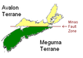 Terranes of Nova Scotia.PNG 281 × 194; 11 KB
-
 The Quarterly journal of the Geological Society of London (12733928133).jpg 3,200 × 1,936; 602 KB
-
 Trace Fossils at Blue Beach in Nova Scotia.jpg 1,024 × 768; 231 KB
-
 Trough xbed mcr1.JPG 3,456 × 2,304; 5.45 MB
-
 Trough xbed mcr2.jpg 3,157 × 2,368; 4.46 MB
-
 West Dover 2004 boulder.jpg 1,918 × 1,705; 1.02 MB
-
 WolfvilleFm 210509 ppl 20x.tif 2,560 × 2,048; 15.01 MB


.jpg)
.jpg)


.jpg)
.jpg)
.jpg)
.jpg)
.jpg)
.jpg)
.jpg)
.jpg)
.jpg)
.jpg)
.jpg)
.jpg)
.jpg)
.jpg)


.jpg)


.jpg)
.jpg)