Category:Geography of San Luis Obispo County, California
Jump to navigation
Jump to search
Counties of California: Alameda · Alpine · Amador · Butte · Calaveras · Colusa · Contra Costa · Del Norte · El Dorado · Fresno · Glenn · Humboldt · Imperial · Inyo · Kern · Kings · Lake · Lassen · Los Angeles · Madera · Marin · Mariposa · Mendocino · Merced · Modoc · Mono · Monterey · Napa · Nevada · Orange · Placer · Plumas · Riverside · Sacramento · San Benito · San Bernardino · San Diego · San Joaquin · San Luis Obispo · San Mateo · Santa Barbara · Santa Clara · Santa Cruz · Shasta · Sierra · Siskiyou · Solano · Sonoma · Stanislaus ·Sutter · Tehama · Trinity · Tulare · Tuolumne · Ventura · Yolo · Yuba – Consolidated city-county: San Francisco
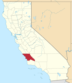
English: The Geography of San Luis Obispo County — in central California.
- Located at the northern reach of Southern California, in the Central Coast region of California, and inland across the central California Coast Ranges to the western edge of the San Joaquin Valley.
Wikimedia category | |||||
| Upload media | |||||
| Instance of | |||||
|---|---|---|---|---|---|
| Category combines topics | |||||
| San Luis Obispo County | |||||
county in California, United States | |||||
| Instance of | |||||
| Named after | |||||
| Location | California, Pacific States Region | ||||
| Capital | |||||
| Inception |
| ||||
| Population |
| ||||
| Area |
| ||||
| official website | |||||
 | |||||
Subcategories
This category has the following 8 subcategories, out of 8 total.
C
G
L
M
Media in category "Geography of San Luis Obispo County, California"
The following 28 files are in this category, out of 28 total.
-
Amtrak Coast Starlight in San Luis Obispo County (cd797e61-6e87-4013-abce-fef515d07684).jpg 2,859 × 2,878; 4.76 MB
-
Beautiful scenes along Route 46 in California LCCN2013632166.tif 7,360 × 4,912; 206.9 MB
-
Beautiful scenes along Route 46 in California LCCN2013632563.tif 6,144 × 4,096; 144.04 MB
-
Beautiful scenes along Route 46 in California LCCN2013632564.tif 6,144 × 4,096; 144.04 MB
-
Beautiful scenes along Route 46 in California LCCN2013632565.tif 6,144 × 4,096; 144.03 MB
-
Beautiful scenes along Route 46 in California LCCN2013632566.tif 6,144 × 4,096; 144.04 MB
-
Beautiful scenes along Route 46 in California LCCN2013632569.tif 6,144 × 4,096; 144.03 MB
-
Beautiful scenes along Route 46 in California LCCN2013632571.tif 6,144 × 4,096; 144.04 MB
-
CA-22nd.png 651 × 400; 38 KB
-
Cerro Cabrillo Panorama.jpg 17,280 × 1,865; 4.69 MB
-
CrkCleanup.jpg 579 × 251; 72 KB
-
Estero second street pier.jpg 800 × 600; 366 KB
-
Grazing cattle, San Joaquin Valley.jpg 4,316 × 2,522; 4.01 MB
-
Greenbelt.jpg 301 × 251; 39 KB
-
Los Osos Irish Hills.jpg 3,888 × 2,592; 5.18 MB
-
Los Ranchos.JPG 2,448 × 1,632; 1.4 MB
-
Mano Seca bench at Selby Campground, Carrizo Plain National Monument.jpg 2,272 × 1,704; 2.93 MB
-
CuyamaValley.jpg 3,300 × 2,550; 1.03 MB
-
Muir Woods National Monument Road Trip (47098489984).jpg 3,000 × 2,020; 4.95 MB
-
MVC00039 (26706333662).jpg 1,344 × 1,024; 687 KB
-
Nacimiento River 1.jpg 1,632 × 1,224; 2.12 MB
-
Point Buchon trail, Diablo Canyon Nuclear Power Plant in background.jpg 4,368 × 2,912; 6.27 MB
-
Point Buchon Trail.jpg 3,000 × 985; 1.16 MB
-
Selby Campground approach.jpg 2,272 × 1,704; 3.15 MB
-
Submarine rock, Mt. de Oro.jpg 3,504 × 2,336; 3.45 MB
-
Waterscape with massive arches and stone outcroppings of Miguelito shale, Point Buchon.jpg 3,598 × 2,399; 4.88 MB


