Category:Demographic maps of Australia
Jump to navigation
Jump to search

Subcategories
This category has the following 43 subcategories, out of 43 total.
*
?
D
I
M
P
R
Media in category "Demographic maps of Australia"
The following 12 files are in this category, out of 12 total.
-
 Australia 2021 English language spoken at home.png 1,810 × 1,528; 203 KB
-
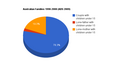 Australian Families 1998-2008 (ABS 2009).png 600 × 371; 14 KB
-
 Australian Hobby Distribution.jpg 1,123 × 727; 120 KB
-
 Australian median ages by statistical region 2011 census.svg 531 × 295; 6.3 MB
-
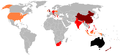
 Australian Permanent Residents by Country of Birth .png 1,357 × 628; 53 KB
-
 Australian population.png 397 × 200; 3 KB
-
 AustralianCensus1921.jpg 579 × 404; 202 KB
-
 COB Australia (2006).PNG 1,357 × 628; 54 KB
-
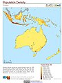 Oceania Population Density (5485515167).jpg 2,386 × 3,174; 735 KB
-
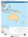
 Oceania Population Density, 2000 (5457017289).jpg 2,550 × 3,243; 741 KB
-
 Oceania Population Density, 2000 (6171915773).jpg 2,399 × 3,160; 685 KB
-
 Population per Australian electoral division.png 6,600 × 4,851; 2.31 MB

.png)


.PNG)
.jpg)
.jpg)
.jpg)
