Category:Carlingford Priory
Jump to navigation
Jump to search

|
This object is indexed in the Archaeological Survey of Ireland under SMR No. LH005-042013-
Geographic information system of the National Monuments Service: Historic Environment Viewer – Database record. |
Dominican priory located in Carlingford, County Louth, Ireland  | |||||
| Upload media | |||||
| Instance of | |||||
|---|---|---|---|---|---|
| Location | County Louth, Leinster, Ireland | ||||
| Heritage designation | |||||
 | |||||
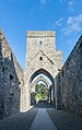
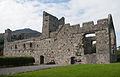
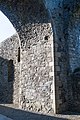
English: The Dominican Priory of St. Malachy was, according to T. de Burgos Hibernica Dominicana, founded in 1305 by Richard de Burgo, Earl of Ulster. The priory was dissolved in 1541 but the friars continued to be active in the area until the 17th century. See pp. 222 in Aubrey Gwynn and R. Neville Hadcock, Medieval Religious Houses Ireland. This site is protected as national monument #623 in state care of Ireland.
Gaeilge: Prióireacht Chairlinne
Media in category "Carlingford Priory"
The following 119 files are in this category, out of 119 total.
-
 NEWENHAM(1830) p185 LOUTH - CARLINGFORD ABBEY.jpg 2,633 × 2,003; 3.81 MB
-
 Abbey Carlingford Inside.jpg 480 × 640; 83 KB
-
 Abbey Carlingford Outside.jpg 640 × 480; 71 KB
-

-
 Bend in the descending 'high road' above Carlingford - geograph.org.uk - 5858904.jpg 3,738 × 2,608; 6.17 MB
-
 Bracken infestation on the North Commons - geograph.org.uk - 5858951.jpg 3,784 × 2,688; 7.39 MB
-
 Bridge on the Tain Way track - geograph.org.uk - 5692090.jpg 4,000 × 3,000; 7.77 MB
-
 Carlingford Abbey.jpg 3,264 × 2,448; 833 KB
-
 Carlingford Adventure Centre in Tholsel Street - geograph.org.uk - 5691344.jpg 2,982 × 3,986; 6.92 MB
-
 Carlingford Fire Station on Greenore Road - geograph.org.uk - 5585864.jpg 2,904 × 3,930; 5.52 MB
-
 Carlingford Heritage Centre - geograph.org.uk - 5588892.jpg 4,000 × 3,000; 2.91 MB
-
 Carlingford Priory and Mountain - geograph.org.uk - 491559.jpg 640 × 480; 114 KB
-
 Carlingford Priory Church Choir 2013 09 22.jpg 2,217 × 3,033; 4.51 MB
-
 Carlingford Priory Church Nave 2013 09 22.jpg 2,092 × 3,328; 5.29 MB
-
 Carlingford Priory Church S 2013 09 22.jpg 3,413 × 2,184; 5 MB
-
 Carlingford Priory Church S II 2013 09 22.jpg 3,373 × 1,882; 4.93 MB
-
 Carlingford Priory Church Tower 2013 09 22.jpg 3,504 × 2,336; 6.7 MB
-
 Carlingford Priory Church Tower II 2013 09 22.jpg 3,504 × 2,336; 6.3 MB
-
 Carlingford Priory Church Tower III 2013 09 22.jpg 3,504 × 2,336; 6 MB
-
 Carlingford Priory Church Tower North Wall 2013 09 22.jpg 2,242 × 3,363; 6.4 MB
-
 Carlingford Priory Church W 2013 09 22.jpg 2,190 × 3,331; 6.18 MB
-
 Carlingford Priory Church W Doorway 2013 09 22.jpg 2,336 × 3,504; 5.79 MB
-
 Carlingford Priory Church W Fortification 2013 09 22.jpg 3,143 × 2,122; 4.79 MB
-
 Carlingford Priory Domestic Range and Tower House 2013 09 22.jpg 3,363 × 2,071; 5.19 MB
-
 Carlingford Priory Domestic Range and Tower House II 2013 09 22.jpg 3,503 × 1,950; 4.57 MB
-
 Carlingford Priory from R173 2013 09 22.jpg 3,409 × 2,057; 3.77 MB
-
 Carlingford Priory from the south - geograph.org.uk - 3160917.jpg 1,024 × 757; 233 KB
-
 Carlingford Priory SW 2013 09 22.jpg 3,430 × 2,055; 5.45 MB
-
 Carlingford town from the upper slopes of Barnavave - geograph.org.uk - 5860145.jpg 3,988 × 2,280; 4.59 MB
-
 Carlingford.jpg 2,304 × 3,456; 3.97 MB
-
 Carlingford02.jpg 2,304 × 3,456; 4.05 MB
-

-
 Colourful buildings in Market Street, Carlingford - geograph.org.uk - 5691363.jpg 4,000 × 3,000; 2.29 MB
-
 County Louth - Carlingford Priory - 20220512134517.jpg 3,915 × 5,863; 8.55 MB
-
 County Louth - Carlingford Priory - 20220512134534.jpg 3,971 × 5,772; 4.95 MB
-
 County Louth - Carlingford Priory - 20220512134605.jpg 4,016 × 6,016; 5 MB
-
 County Louth - Carlingford Priory - 20220512134623.jpg 3,940 × 5,902; 6.21 MB
-
 County Louth - Carlingford Priory - 20220512134644.jpg 6,016 × 4,016; 4.77 MB
-
 County Louth - Carlingford Priory - 20220512134853.jpg 6,016 × 4,016; 4.7 MB
-
 County Louth - Carlingford Priory - 20220512135011.jpg 4,016 × 6,016; 5.06 MB
-
 Crenellated house at St Oliver's Park, Carlingford - geograph.org.uk - 5858787.jpg 1,780 × 1,644; 1.86 MB
-
 Cul na Bala, Carlingford - geograph.org.uk - 5691716.jpg 2,904 × 1,991; 3.24 MB
-
 Descending into Carlingford along Grove Road - geograph.org.uk - 5591839.jpg 2,668 × 2,000; 3.05 MB
-
 Desmond Savage Victuallers in Market Street, Carlingford - geograph.org.uk - 5691710.jpg 2,920 × 3,940; 5.73 MB
-
 Dominican Priory Carlingford - geograph.org.uk - 986575.jpg 428 × 640; 102 KB
-
 Dominican Priory Carlingford.jpg 640 × 427; 92 KB
-
 Entering the old town through the Tholsel - geograph.org.uk - 5692851.jpg 4,000 × 3,000; 2.86 MB
-
 Farmland between the 'high road' and the town of Carlingford - geograph.org.uk - 5860091.jpg 3,976 × 2,968; 7.11 MB
-

-
 Forestry track ascending from the top of River Lane - geograph.org.uk - 5695338.jpg 3,292 × 2,217; 3.31 MB
-

-
 Grove Hill climbing a drumlin slope - geograph.org.uk - 5582984.jpg 4,000 × 3,000; 3.06 MB
-
 Grove House B^B, Grove Road, Carlingford - geograph.org.uk - 5582340.jpg 2,668 × 2,000; 2.76 MB
-

-
 Harbour Cottages and Oyster Bay Court, Carlingford - geograph.org.uk - 5691204.jpg 3,938 × 2,916; 3.19 MB
-
 Hill slope grazing land above Carlingford - geograph.org.uk - 5858935.jpg 3,482 × 2,535; 6.79 MB
-
 Holy Trinity Heritage Centre, Carlingford - geograph.org.uk - 5589075.jpg 2,669 × 2,000; 2.11 MB
-
 Intake land between the town of Carlingford and the Commons - geograph.org.uk - 5858931.jpg 3,624 × 2,370; 6.02 MB
-

-

-
 Looking back towards the entrance.jpg 3,000 × 4,512; 7.63 MB
-
 Looking down the Abbey.jpg 3,000 × 4,512; 7.23 MB
-
 Ma Bakers PH in Market Square, Carlingford - geograph.org.uk - 5690659.jpg 4,000 × 3,000; 2.48 MB
-
 Marginal land on the lower slopes of Slieve Foye - geograph.org.uk - 5858944.jpg 3,079 × 2,448; 5.47 MB
-

-
 Mountain path ascending alongside a sheepfold - geograph.org.uk - 5695379.jpg 3,096 × 2,092; 4.41 MB
-

-
 Open stream in River Lane - geograph.org.uk - 5692117.jpg 3,000 × 4,000; 6.41 MB
-
 Oyster Bay Court Housing Estate - geograph.org.uk - 5585869.jpg 3,959 × 2,602; 3.34 MB
-
 Rear view of The Manse, Carlingford - geograph.org.uk - 5688376.jpg 3,301 × 2,581; 5.01 MB
-
 Road junction on Grove Road - geograph.org.uk - 5582978.jpg 3,814 × 2,000; 4.83 MB
-
 Semi-detached stone house in Old Quay Lane, Carlingford - geograph.org.uk - 5547261.jpg 3,264 × 2,448; 1.97 MB
-
 Slieve Foye from Dundalk Street, Carlingford - geograph.org.uk - 5589124.jpg 3,615 × 1,977; 3.65 MB
-
 Slieve Foye viewed from the top of River Lane, Carlingford - geograph.org.uk - 5700294.jpg 3,402 × 2,190; 4.31 MB
-
 St Michael's Catholic Chapel, Carlingford - geograph.org.uk - 5857737.jpg 2,806 × 3,037; 3.07 MB
-

-
 St Oliver's National School, Dundalk Street, Carlingford - geograph.org.uk - 5547385.jpg 3,264 × 2,448; 1.96 MB
-
 The Carlingford Commons from the slopes of Barnavave - geograph.org.uk - 5578973.jpg 3,264 × 2,448; 1.97 MB
-
 The Church of St Michael, Carlingford - geograph.org.uk - 5544836.jpg 2,778 × 1,540; 821 KB
-
 The east window of Carlingford Abbey - geograph.org.uk - 3106674.jpg 768 × 1,024; 265 KB
-
 The eastern end of Carlingford Harbour at low water - geograph.org.uk - 5585876.jpg 3,165 × 1,923; 3.2 MB
-

-
 The great east window of Carlingford Priory - geograph.org.uk - 3160864.jpg 1,024 × 754; 213 KB
-

-
 The junction of Dundalk Street and Newry Street, Carlingford - geograph.org.uk - 5857715.jpg 3,377 × 2,151; 3.86 MB
-
 The junction of the R173 and Grove Road (L7042) - geograph.org.uk - 5582999.jpg 2,452 × 1,654; 781 KB
-
 The Meadow Grove Estate on the outskirts of Carlingford - geograph.org.uk - 5582970.jpg 3,479 × 1,892; 4.54 MB
-
 The Mill Dam Lane - geograph.org.uk - 5547310.jpg 3,264 × 2,448; 1.98 MB
-
 The Mint in Tholsel Street, Carlingford - geograph.org.uk - 5547271.jpg 2,302 × 3,070; 1.34 MB
-
 The nave and chancel of Carlingford Abbey - geograph.org.uk - 3112672.jpg 745 × 1,024; 244 KB
-
 The nave of the ruined Carlingford Priory - geograph.org.uk - 4432221.jpg 1,200 × 1,600; 510 KB
-
 The Pump House, Tholsel Street, Carlingford - geograph.org.uk - 5547267.jpg 3,264 × 2,448; 1.99 MB
-
 The R173 in the southern suburbs of Carlingford - geograph.org.uk - 5547558.jpg 2,446 × 2,363; 1.08 MB
-
 The River Lane défilé - geograph.org.uk - 5691734.jpg 4,000 × 3,000; 2.44 MB
-
 The ruined domestic buildings of Carlingford Priory - geograph.org.uk - 5589103.jpg 2,668 × 2,000; 2.93 MB
-
 The ruined medieval priory at Carlingford - geograph.org.uk - 5857732.jpg 3,175 × 2,005; 3.05 MB
-
 The ruins of Carlingford Friary - geograph.org.uk - 5548143.jpg 3,264 × 2,448; 1.97 MB
-

-
 The Tholsel viewed from inside the medieval town - geograph.org.uk - 5692860.jpg 3,838 × 2,770; 5.62 MB
-
 The Thosel Gate from the R173 car park - geograph.org.uk - 5589086.jpg 2,668 × 2,000; 3.07 MB
-
 The top of River Lane, Carlingford - geograph.org.uk - 5692052.jpg 4,000 × 3,000; 6.83 MB
-

-
 The town of Carlingford from the lower slopes of Slieve Foye - geograph.org.uk - 5692043.jpg 4,000 × 1,823; 3.36 MB
-
 The town of Carlingford from the Táin Trail - geograph.org.uk - 5568545.jpg 2,842 × 2,067; 1.31 MB
-
 The town of Carlingford from the upper slopes of Barnaveve - geograph.org.uk - 5578966.jpg 3,264 × 2,448; 1.98 MB
-
 The west door of Carlingford Priory - geograph.org.uk - 5588898.jpg 3,000 × 4,000; 2.66 MB
-
 Towers of the ruined Dominican Friary, Carlingford - geograph.org.uk - 5547531.jpg 1,497 × 1,498; 534 KB
-
 Track leading to the Commons - geograph.org.uk - 5858770.jpg 3,199 × 2,062; 4.93 MB
-
 Traditional white washed cottage in Grove Road, Carlingford - geograph.org.uk - 5547585.jpg 3,009 × 2,257; 1.31 MB
-
 Vehicle travelling south along the R173 - geograph.org.uk - 5547593.jpg 2,003 × 2,003; 677 KB
-

-
 View East from the junction of River Lane and Cul na Bala - geograph.org.uk - 5691726.jpg 2,668 × 2,000; 2.67 MB
-
 View ESE along Grove Road - geograph.org.uk - 5589138.jpg 2,621 × 1,939; 2.78 MB
-
 View ESE along Tholsel Street, Carlingford - geograph.org.uk - 5547263.jpg 3,264 × 2,448; 1.95 MB
-

-
 View South along Dundalk Street, Carlingford - geograph.org.uk - 5589108.jpg 3,389 × 2,013; 3.27 MB
-

-

-
 View WSW along Market Street, Carlingford - geograph.org.uk - 5691650.jpg 2,668 × 2,000; 2.4 MB
_p185_LOUTH_-_CARLINGFORD_ABBEY.jpg)


_-_geograph.org.uk_-_5591841.jpg)


_-_geograph.org.uk_-_5582999.jpg)


Categories:
- Objects of County Louth recorded in the Archaeological Survey of Ireland with known IDs
- Carlingford, County Louth
- Monasteries in County Louth
- Dominican monasteries in Ireland
- Dominican monasteries established in the 1300s
- 1300s monasteries in Ireland
- Monasteries established in 1305
- Monasteries disestablished in 1541
- Ruins of monasteries in Ireland
- Saint Malachy churches in Ireland
- Cultural heritage monuments in County Louth
- 1305 establishments in Ireland
- Ruins of churches in County Louth
- Ruins of Gothic churches in Ireland
- 14th-century churches in Ireland
- Aisleless churches in Ireland
- Suppressed monasteries (Reformation in Ireland)