Category:CIA Indian Ocean Atlas
Jump to navigation
Jump to search
English: This category is for media from „The Indian Ocean Atlas“ published by the Central Intelligence Agency in 1976
Media in category "CIA Indian Ocean Atlas"
The following 37 files are in this category, out of 37 total.
-
 Addu atoll 76.jpg 496 × 452; 55 KB
-
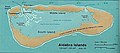 Aldabra islands seychelles 76.jpg 847 × 374; 70 KB
-
 Andaman nicobar 76.jpg 894 × 2,068; 315 KB
-
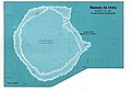 Bassas da india 76.jpg 946 × 646; 116 KB
-
 Christmas island 76.svg 1,049 × 968; 478 KB
-
 Cocos(keeling) 76.jpg 885 × 1,023; 141 KB
-
 Anjouan (Comoros) map.jpg 350 × 382; 23 KB
-
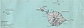
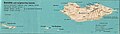
 Comoros country map 1976, CIA.jpg 1,348 × 874; 198 KB
-
 Grand Comore (Comoros) map.jpg 402 × 819; 39 KB
-
 Mayotte 76.jpg 420 × 832; 71 KB
-
 Moheli (Comoros) map.jpg 354 × 320; 19 KB
-
 Desroches 76.png 392 × 413; 291 KB
-
 Farquhar atoll.jpg 407 × 431; 38 KB
-
 Gan 76.jpg 411 × 429; 38 KB
-
 Heard mcdonald 76.jpg 1,267 × 431; 64 KB
-
 Ile amsterdam stpaul 76.jpg 910 × 710; 141 KB
-
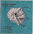 Ile aux Cochons Map.jpg 349 × 362; 32 KB
-
 Ile europa 76.jpg 948 × 442; 64 KB
-
 Ile juan de nova 76.jpg 932 × 490; 80 KB
-
 Ile tromelin 76.jpg 370 × 336; 28 KB
-
 Iles glorieuses 76.jpg 896 × 550; 102 KB
-
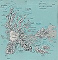 Iles Kerguelen 76.jpg 857 × 891; 170 KB
-
 Khuriya muriya 76.jpg 436 × 360; 31 KB
-
 Lakshadweep map.jpg 882 × 1,222; 171 KB
-
 Mahe island 76.jpg 423 × 559; 56 KB
-
 Malikatholhu.png 374 × 374; 241 KB
-
 Map of Christmas Island 1976.jpg 839 × 766; 692 KB
-
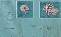 Map of Crozet Islands.jpg 1,279 × 784; 206 KB
-
 Masirah 76.jpg 426 × 354; 37 KB
-
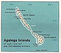 Agalega islands 76.jpg 437 × 378; 36 KB
-
 Cargados carajos 76.jpg 439 × 1,275; 96 KB
-
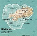 Rodrigues 76.jpg 409 × 405; 151 KB
-
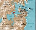
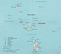 Nicobar Islands.jpg 643 × 564; 70 KB
-
 Prince Edward Islands 76.jpg 405 × 628; 45 KB
-
 Socotra 76.jpg 1,309 × 375; 100 KB
-
 Viperisland.jpg 413 × 343; 100 KB
-
 Zanzibar (tanzania).jpg 354 × 522; 44 KB


_76.jpg)
_map.jpg)

_map.jpg)

_map.jpg)


.jpg)