Category:Buffalo National River
Jump to navigation
Jump to search
national river in northern Arkansas, USA  | |||||
| Upload media | |||||
| Instance of | |||||
|---|---|---|---|---|---|
| Named after |
| ||||
| Location | Arkansas | ||||
| Located in or next to body of water |
| ||||
| Operator | |||||
| Heritage designation |
| ||||
| IUCN protected areas category | |||||
| Visitors per year |
| ||||
| Different from | |||||
| official website | |||||
 | |||||
Subcategories
This category has the following 10 subcategories, out of 10 total.
Media in category "Buffalo National River"
The following 152 files are in this category, out of 152 total.
-

-
 A hazy sunrise behind frosty, wooded hills (5ee6bc4d-cfc0-45cb-86f1-f06ec68a8290).JPG 5,472 × 3,648; 7.94 MB
-
 A herd of elk at Steel Creek in winter (66003542-eda3-4d7d-88dd-5a48f4a8f393).JPG 3,648 × 2,048; 4.57 MB
-

-

-
 A Tent in E Loop (0ef3ef94-1dd8-b71b-0beb-8f7aa67f4874).JPG 4,000 × 3,000; 4.86 MB
-

-
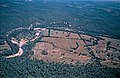
 Aerial photo of Jim's Bluff area. (0c6317dd-5ec4-4b21-8256-bfab71a63050).jpg 1,040 × 1,616; 553 KB
-
 Aerial view of Buffalo Point. (b0d84010-0d11-4271-adcd-86b6d1b358f3).jpg 1,536 × 1,056; 518 KB
-

-
 Aerial view of Carver low water bridge. (55fb771c-efaf-4a3b-8219-4703af67ceac).jpg 1,568 × 1,056; 567 KB
-
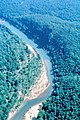
 Aerial view of confluence with White River. (c3854b41-4195-4ce0-bfd7-9cbd30d9f894).jpg 1,599 × 1,039; 408 KB
-
 Aerial view of Gilbert. (a9c8d19c-7e0e-4c14-80ce-59a6c4fb9ada).jpg 782 × 504; 142 KB
-
 Aerial view of highway 14 bridge. (65bb5717-900a-4165-a814-6526e9ceff58).jpg 1,039 × 1,570; 505 KB
-
-
-
 Aerial view of Steel Creek. (6797cbdd-c103-4d02-bf42-d02207d68d48).jpg 1,120 × 1,632; 542 KB
-
 Aerial view of Tyler Bend. (6c25803d-719e-4731-b4c8-1ef4d7ba8f2b).jpg 802 × 522; 145 KB
-
 Aerial view of Woolum. (bd606fc9-cf66-4e48-810e-07a1bd374e4a).jpg 802 × 504; 126 KB
-
 All But Dried Up (4d0911dc-5f0b-4221-a7ff-6ec0385b37ec).JPG 5,472 × 3,648; 10.9 MB
-
 Another photo of Big Bluff. (d860ffb0-c3e0-4abd-9ea7-45e3ba144cf8).jpg 540 × 784; 160 KB
-

-
 Autumn Sunrise over Lower Buffalo Wilderness (25359b15-6637-480f-a6c6-14241303fd39).JPG 5,472 × 3,648; 5.64 MB
-

-
 Bluff at Buffalo Point (df108e5c-155d-4519-3e55-801e07f20058).jpg 1,500 × 916; 695 KB
-
 Bluff in Indian Creek. (69030aed-a26e-45de-8dcd-2ba9521b462e).jpg 520 × 784; 163 KB
-
 Bluff near Middle Creek Road. (8a4f458b-d70b-4261-8f8d-acb39f30f119).jpg 802 × 504; 184 KB
-
 Bluff toward Blue Hole (df420ce3-155d-4519-3e14-9ae3da0026fc).jpg 1,500 × 927; 693 KB
-

-
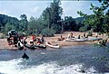
 Boats and people at Ponca low water bridge. (35fa9bd8-fcd5-4407-9ad7-fde7721315fc).jpg 1,616 × 1,056; 516 KB
-
 Boats and people on river bank. (967aa79a-3a27-467e-9582-6f303547778a).jpg 1,536 × 1,056; 433 KB
-

-
 Bridge over the Buffalo River, Arkansas.jpg 2,592 × 1,728; 1.15 MB
-
-
 Buffalo Little Buffalo confluence.jpg 1,536 × 2,048; 864 KB
-
 Buffalo National River at Carver Landing 001.jpg 3,888 × 2,592; 2.39 MB
-
 Buffalo National River at Carver Landing 002.jpg 3,888 × 2,592; 1.91 MB
-
 Buffalo National River BUFF0628.jpg 3,072 × 2,048; 4.07 MB
-
 Buffalo National River BUFF4529.jpg 3,072 × 2,048; 4.59 MB
-
 Buffalo national river steel creek overlook.jpg 5,964 × 2,798; 4.29 MB
-
 Buffalo National River, Harrison, AR.png 1,920 × 1,080; 5.2 MB
-
 Buffalo National River.jpg 375 × 180; 29 KB
-
 Buffalo Point Overlook in Autumn (f00d5600-6b9e-4b5c-b2fa-a3d21c0862cb).JPG 5,472 × 3,648; 8.92 MB
-
 Buffalo River & Big Bluff (9aac643a-1dd8-b71b-0b0d-89e5dde3e79f).jpg 2,100 × 1,503; 2.28 MB
-
 Buffalo River banner.jpg 2,000 × 285; 442 KB
-
 Buffalo River Bluffs.jpg 2,400 × 1,600; 1.47 MB
-
 Buffalo River Ponca Low Water Bridge.JPG 800 × 600; 100 KB
-
 Buffalo River Pruitt Landing.JPG 800 × 600; 117 KB
-
 Buffalo River Trail, Ozark to Pruitt (5b321d17-1478-49ec-8e6c-be257659089b).JPG 5,472 × 3,648; 13.54 MB
-
 Buffalo River Trail, Ozark to Pruitt (7da51714-2a4d-40d1-84ba-9c043d963c33).JPG 3,648 × 2,432; 4.04 MB
-
 Buffalo River trail.jpg 2,160 × 2,880; 1.71 MB
-
 Buffalo River, national river, Arkansas LOC 80691752.jpg 10,036 × 4,710; 8.05 MB
-
 Buffalo River, national river, Arkansas LOC 86694141.jpg 10,005 × 4,775; 7.93 MB
-
 BuffaloRiver.jpg 270 × 350; 23 KB
-
 Canoeing in the fall. (242f4aba-dc5b-4010-a7b5-19826580935e).jpg 1,608 × 1,040; 506 KB
-
 Cedar Glades Pond Trailhead (7059f41a-9d68-4b4b-b5d1-3e59860de1a5).JPG 5,472 × 3,648; 7.03 MB
-
 Centerpoint Trail in Summer (ff64cb5b-30bd-4187-8c20-d2d026aa7b13).JPG 5,472 × 3,648; 6.33 MB
-
 Closer view of Ludlow bluff. (d18550f0-df20-412e-8bf7-03b19ec08ac9).jpg 520 × 802; 112 KB
-
 Drive In Campsite at Tyler Bend (f14ec88d-155d-4519-3e26-8d747093d9af).jpg 2,000 × 1,500; 1.51 MB
-

-
 Entrance area to campground. (4bf83013-2e45-40a2-bdbe-db3396668f33).jpg 1,648 × 1,056; 463 KB
-
 Erbie church Front After restoration (8c376003-1dd8-b71b-0b4b-8e5c57701994).jpg 1,500 × 1,126; 603 KB
-
 Erbie church Front Before restoration (8c3adbc3-1dd8-b71b-0b03-cc4762f11f74).jpg 1,536 × 2,560; 1.53 MB
-
 Exhibit panel at overlook (74fb42fa-9daa-426c-9883-01bd8de7cd67).JPG 4,000 × 3,000; 4.28 MB
-
 Fall colors along river. (00b11a14-79e1-49a1-aa06-d15edb0bde0a).jpg 1,604 × 1,040; 553 KB
-
 Fall colors in the western end of Buffalo NR. (d511b033-3ece-4f32-b903-046ce5c45731).JPG 4,608 × 3,456; 5.34 MB
-
 Fall colors. (39f4cb40-eda4-4cf8-a101-8688af11e7f6).JPG 4,000 × 3,000; 4.04 MB
-

-
 Fishing the Buffalo (3461923171).jpg 1,600 × 1,200; 379 KB
-
 Fsdgsfdg (1e91834b-6bc6-46dd-98e4-df27291efab9).jpg 542 × 784; 139 KB
-
 Goat Bluff Overlook (Erbie) (64ce0a17-e5c6-4f99-847e-938f827cfee7).JPG 5,472 × 3,072; 10.02 MB
-
 Gravel beach at Buffalo Point. (6c98ed3d-2f66-40cd-88a0-f24c76715fbd).jpg 1,601 × 1,049; 513 KB
-
 Group Site at Tyler Bend (f19170e3-155d-4519-3eb6-a21feefaec64).jpg 2,000 × 1,500; 1.17 MB
-
 Hemmed-in Hollow Falls, Ponca Wilderness (4c2414cb-b07a-4704-8a86-34c5ff297211).JPG 2,432 × 3,648; 5.3 MB
-
 Hillside with green plants with white flowers. (e8220c3f-7ed6-4e2f-9ae2-e242c0f88ada).JPG 4,000 × 3,000; 4.03 MB
-
 Icicles at Lost Valley (e059d346-2c77-4af0-81dd-833b222d6921).JPG 5,472 × 3,648; 8.66 MB
-
 Interior of Pavilion 1 (0f32a1ed-1dd8-b71b-0b90-9947682d29a1).JPG 3,872 × 2,592; 4.05 MB
-
 Interior View of Pavilion 2 (0f8cc484-1dd8-b71b-0b13-e702c9f18ca2).JPG 3,872 × 2,592; 3.96 MB
-
 Interior View of Pavilions 3 (0fd8b70c-1dd8-b71b-0b1c-bee747138456).JPG 3,872 × 2,592; 3.68 MB
-
 Kyles Landing launch area. (316733c4-3722-4b63-9eaa-bcc817a8e569).jpg 1,040 × 1,616; 430 KB
-
 Launch area at Carver. (eaec3586-3fdc-425b-a872-391388e5e40b).jpg 1,536 × 1,056; 504 KB
-
 Launch area at Pruitt. (ee6a8d6e-dad0-4f93-b9af-83f289826c3f).jpg 1,600 × 1,056; 519 KB
-
 Launch area at Steel Creek. (52d518d6-3938-471a-90e2-206f7ba26aff).jpg 1,616 × 1,056; 481 KB
-

-
 Long bluff along large field. (96a5baa8-23e8-4ddf-b777-24ae66499d36).jpg 822 × 522; 101 KB
-

-

-
 Lower Buffalo Wilderness in Summer (f06510e5-91ea-451d-b778-392e166cc7ca).JPG 5,472 × 3,648; 8.39 MB
-
 Mill Creek Trail, Pruitt (3b48896c-f373-42e5-b9ef-f6f556910d41).jpg 960 × 720; 200 KB
-
 Misty Bluff along the Buffalo River.jpg 3,072 × 2,304; 1.73 MB
-
 Morning on the Buffalo River.jpg 3,264 × 2,448; 2.9 MB
-

-
 North Side of Erbie Church After restoration (8c423d26-1dd8-b71b-0b6e-81171df59284).jpg 5,312 × 2,988; 5.69 MB
-

-
 Old low water crossing (pan).jpg 7,426 × 2,135; 4.54 MB
-
 Overlooking The Buffalo River.jpg 2,200 × 1,467; 4.39 MB
-
 Ozark Wake RobinOzark Trillium (325821ce-c97d-4824-891c-7d80f879488b).jpg 1,728 × 1,296; 516 KB
-

-

-

-

-

-
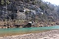
 River flowing over concrete slab. (448b99c3-0122-419e-8db9-9a7182e62ba4).jpg 1,568 × 1,056; 424 KB
-
 River view upstream from Ponca access. (4d457908-8506-4d23-aa61-b856d44b10b2).JPG 4,000 × 3,000; 3.93 MB
-
 Roark Bluff in Winter (d1904d5e-2b03-46e1-bd96-6192ee7a2dc3).JPG 5,472 × 3,648; 6.61 MB
-
 Rock layers along river. (c255d94f-612b-4e9d-a86a-92974cbb521b).jpg 522 × 802; 175 KB
-
 Sandy Beach at Hasty Access (09c5c7ae-1061-4456-826e-d6f027543ef5).JPG 5,472 × 3,648; 6.28 MB
-
 Scene on Buffalo River between Harrison and Jasper, Arkansas on highway no. 7 (80857).jpg 3,271 × 2,070; 3.23 MB
-

-

-

-
 Skull Rock in Autumn (af643675-68aa-4dbd-8900-f21fa433c455).JPG 5,472 × 3,648; 7.55 MB
-
 Snowstorm at Steel Creek Campground (624ed6c7-8dda-4d27-bfbe-aafb2b30d9a5).JPG 5,472 × 3,648; 6.15 MB
-
 Snowy Roark Bluff and the Buffalo River in winter (387f46e8-6e0b-4d30-9f50-2847e97cb4dc).JPG 5,472 × 3,648; 6.56 MB
-

-

-

-
 The Buffalo River Trail traverses a snowy forest (372a1861-b712-49fb-b8e1-ea6f4783b9c0).JPG 5,472 × 3,648; 12.16 MB
-
 The Buffalo River Trail traverses a snowy forest (9fb6b046-0de1-4583-86e3-82a875999dec).JPG 5,472 × 3,648; 13.13 MB
-

-

-

-

-

-

-

-
 Tyler Bend Drive In Site (034a657e-1dd8-b71b-0b9b-80e628cb97ea).jpg 816 × 612; 150 KB
-
 Tyler Bend Group Campground (f1739e03-155d-4519-3eca-46b134fc13b7).jpg 2,000 × 1,500; 1.32 MB
-
 Tyler Bend picnic area. (b388816e-9b50-470c-b743-9dcbf16284e1).jpg 1,600 × 1,072; 536 KB
-
 Upriver from Ponca low water bridge. (a1d4ff92-7125-4306-bf59-2425da1e8bc4).JPG 3,000 × 4,000; 4.1 MB
-
 View along river with snow. (9292ea84-a8df-43b6-8d9f-d0b8e6dce8d2).jpg 802 × 504; 180 KB
-
 View downriver from Love Hensley gravel bar (dfc830c9-155d-4519-3e9b-dbcd0766f171).jpg 1,500 × 2,250; 871 KB
-
 View downriver through the wilderness (dfddfffe-155d-4519-3ed4-0b503d7ea074).jpg 1,200 × 900; 307 KB
-
 View from overlook behind Collier Homestead (a4b05d40-4d72-4118-91b2-b6a3d8863b37).JPG 4,000 × 3,000; 3.82 MB
-
 View from Peter Cave Bluff overlook (e0a6f761-155d-4519-3ef5-dd8fcff2af7f).jpg 1,500 × 2,250; 1,000 KB
-
 View from the middle of the river (dfb49454-155d-4519-3e52-715a832e92db).jpg 1,500 × 1,125; 952 KB
-
 View from the river toward a high bluff (dfff852d-155d-4519-3e6d-1ab9b67aa359).jpg 1,500 × 2,000; 1.71 MB
-
 View of "skull bluff" from opposite riverbank (e030539c-155d-4519-3e29-922da2fbf28b).jpg 1,500 × 2,017; 1.02 MB
-
 View of bluff across hollow. (5e95cc06-5658-428b-8cc4-11d1e8bd79e0).jpg 780 × 504; 179 KB
-
 View of bluff across river. (01223840-6103-491c-bab1-27d4e7a39df7).jpg 781 × 503; 119 KB
-
 View of bluff from below. (27457305-631e-4b14-b2af-cf4cebce67c2).jpg 802 × 504; 118 KB
-
 View of river and bluff. (f1d5c608-88d1-4234-adb0-c9b97ab7fac9).jpg 520 × 802; 171 KB
-
 View of river from above (dfeb120a-155d-4519-3ecd-b0a9132ced6c).jpg 1,500 × 1,125; 616 KB
-
 View of Roark Bluff from opposite riverbank (e01c4fa4-155d-4519-3ecf-7f75b3303dcb).jpg 1,001 × 1,500; 658 KB
-
 View of Steel Creek area (e0bfb9b6-155d-4519-3e0e-724e51a94712).jpg 1,500 × 1,125; 263 KB
-
 View of the "Nars" (e06220b2-155d-4519-3e83-1701cf22d16b).jpg 1,500 × 2,000; 1.8 MB
-

-
 View upriver from a blufftop (e07f05fd-155d-4519-3e63-0cbc684fe64e).jpg 1,500 × 945; 682 KB
-
 Visitors walking past old mercantile. (2420e424-a55d-48df-8526-7dca07c76507).jpg 1,536 × 1,072; 497 KB
-
 Walk In Tent Sites (f1b2d071-155d-4519-3e53-a8444e6d27d7).jpg 2,000 × 1,500; 1.45 MB
-

-
 Wayside panel at overlook (252a733b-20a9-4ebb-9f42-3a9848b53221).JPG 4,000 × 3,000; 4.26 MB
.JPG)
.JPG)
.JPG)
.JPG)
.jpg)
.JPG)
.JPG)
.jpg)
.jpg)
.jpg)
.jpg)
.jpg)
.jpg)
.jpg)
.jpg)
.jpg)
.jpg)
.jpg)
.jpg)
.JPG)
.jpg)
.jpg)
.JPG)
.jpg)
.jpg)
.jpg)
.jpg)
.jpg)
.JPG)
.jpg)
.jpg)
.jpg)

.JPG)


.JPG)
.jpg)


.JPG)
.JPG)


.jpg)
.JPG)
.JPG)
.jpg)
.jpg)
.jpg)
.jpg)
.jpg)
.JPG)
.jpg)
.JPG)
.JPG)
.jpg)
.jpg)
.jpg)
_(64ce0a17-e5c6-4f99-847e-938f827cfee7).JPG)
.jpg)
.jpg)
.JPG)
.JPG)
.JPG)
.JPG)
.JPG)
.JPG)
.jpg)
.jpg)
.jpg)
.jpg)
.JPG)
.jpg)
.jpg)
.jpg)
.JPG)
.jpg)


.JPG)
.jpg)
.jpg)

.jpg)
.jpg)
.JPG)
.JPG)
.JPG)
.jpg)
.jpg)
.JPG)
.JPG)
.jpg)
.JPG)
.jpg)
.JPG)
.jpg)
.jpg)
.JPG)
.JPG)
.JPG)
.jpg)
.JPG)
.JPG)
.JPG)
.JPG)
.JPG)
.JPG)
.jpg)
.JPG)
.jpg)
.jpg)
.jpg)
.jpg)
.jpg)
.JPG)
.jpg)
.jpg)
.jpg)
.JPG)
.jpg)
.jpg)
.jpg)
.jpg)
.jpg)
.jpg)
.jpg)
.jpg)
.jpg)
.jpg)
.jpg)
.jpg)
.jpg)
.jpg)
.jpg)
.jpg)
.jpg)
.JPG)
.jpg)
.jpg)
.jpg)