Category:Bodies of water in Ireland
Jump to navigation
Jump to search
Wikimedia category | |||||
| Upload media | |||||
| Instance of | |||||
|---|---|---|---|---|---|
| Category combines topics | |||||
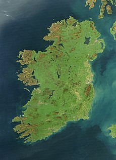
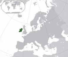
| Ireland | |||||
island in the North Atlantic Ocean | |||||
| Pronunciation audio | |||||
| Instance of | |||||
| Part of | |||||
| Location | British Isles, Europe, Northern hemisphere | ||||
| Located in or next to body of water | |||||
| Width |
| ||||
| Length |
| ||||
| Highest point |
| ||||
| Population |
| ||||
| Area |
| ||||
| Different from | |||||
 | |||||
Subcategories
This category has the following 18 subcategories, out of 18 total.
Media in category "Bodies of water in Ireland"
The following 47 files are in this category, out of 47 total.
-
Bloody Pass - geograph.org.uk - 36394.jpg 640 × 411; 114 KB
-
Crockalough - geograph.org.uk - 555862.jpg 640 × 296; 20 KB
-
Glendalough - geograph.org.uk - 665943.jpg 640 × 416; 52 KB
-
Loch Sliabh Sneachda - geograph.org.uk - 557560.jpg 640 × 429; 70 KB
-
Lough Nambrackdarrig - geograph.org.uk - 245338.jpg 640 × 480; 87 KB
-
Lough Nambrackdarrig - geograph.org.uk - 245342.jpg 640 × 480; 89 KB
-
On Lough Hyne, Co. Cork - geograph.org.uk - 364720.jpg 640 × 424; 55 KB
-
Rosroe Quay, Killary Harbour - geograph.org.uk - 102620.jpg 640 × 480; 84 KB
-
Ruined cottages, Lough Unshagh - geograph.org.uk - 14517.jpg 640 × 429; 57 KB
-
The Kenmare River - geograph.org.uk - 1222710.jpg 640 × 390; 52 KB
-
Barfinnihy Lough - geograph.org.uk - 291112.jpg 640 × 480; 54 KB
-
Barfinnihy Lough - geograph.org.uk - 291119.jpg 640 × 480; 68 KB
-
Barfinnihy Lough - geograph.org.uk - 291129.jpg 640 × 480; 57 KB
-
Blackwater River - geograph.org.uk - 17877.jpg 640 × 480; 336 KB
-
Fishing boats on Killary Harbour - geograph.org.uk - 201345.jpg 517 × 640; 118 KB
-
Glas Lough - geograph.org.uk - 276200.jpg 640 × 480; 107 KB
-
Killary Harbour on a summer evening - geograph.org.uk - 201333.jpg 640 × 430; 116 KB
-
Lake at Lay-By In Connor Pass - geograph.org.uk - 425617.jpg 480 × 640; 82 KB
-
Loch an Chuais - geograph.org.uk - 292592.jpg 640 × 480; 70 KB
-
Loch an Ghainimh - geograph.org.uk - 397913.jpg 640 × 480; 49 KB
-
Loch an Luir from Loughanuire town - geograph.org.uk - 305416.jpg 640 × 422; 76 KB
-
Loch na hEornan - geograph.org.uk - 263362.jpg 640 × 480; 72 KB
-
Lochan, Knocknamaddree - geograph.org.uk - 262967.jpg 640 × 480; 92 KB
-
Lough Boy - geograph.org.uk - 245008.jpg 640 × 480; 58 KB
-
Lough Ine - geograph.org.uk - 25103.jpg 640 × 353; 67 KB
-
Lough Iochtair - geograph.org.uk - 332005.jpg 640 × 480; 60 KB
-
Lough Mourne in winter - geograph.org.uk - 674058.jpg 640 × 480; 111 KB
-
Lough Nafooey - geograph.org.uk - 505525.jpg 640 × 480; 67 KB
-
Pool along the N71 - geograph.org.uk - 16096.jpg 640 × 480; 348 KB
-
Pool amongst benches - geograph.org.uk - 276194.jpg 640 × 480; 78 KB
-
Self portrait with Killary Harbour - geograph.org.uk - 201131.jpg 640 × 459; 150 KB
-
The loch at Gleann Bheatha - geograph.org.uk - 69007.jpg 496 × 600; 257 KB
-
Tidal Oddity - geograph.org.uk - 457948.jpg 615 × 640; 120 KB
-
View down Killary Harbour - geograph.org.uk - 201442.jpg 640 × 497; 116 KB
-
View east along Killary Harbour - geograph.org.uk - 201409.jpg 640 × 439; 121 KB
-
View east by Church Lough, Inishbofin - geograph.org.uk - 199520.jpg 640 × 477; 125 KB
-
View north to Loch na Snathaide - geograph.org.uk - 305403.jpg 640 × 423; 72 KB
-
View of the lake near a parking area - geograph.org.uk - 16084.jpg 640 × 480; 294 KB
-
View over Meenlecknalbre - geograph.org.uk - 305407.jpg 640 × 414; 65 KB
-
Waterbody 103 on the Sheepshead Peninsula - geograph.org.uk - 15016.jpg 640 × 480; 375 KB


