Category:Agricultural maps of Turkey
Jump to navigation
Jump to search
Media in category "Agricultural maps of Turkey"
The following 10 files are in this category, out of 10 total.
-
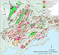
 Agricultural map of Turkey - production of certain agricultural commodities, 1935-1937.jpg 9,837 × 6,910; 6.37 MB
-
 Das Südost-Anatolien-Teilprojekt in der Urfa-Harran-Ebene.jpg 789 × 603; 174 KB
-
 Landnutzungsmuster im Yavu-Bergland.jpg 3,343 × 3,089; 1.44 MB
-
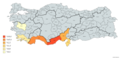
 Turkey cotton regions.jpg 651 × 362; 70 KB
-
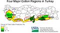
 Turkey-cotton-by-region-map.jpg 288 × 107; 9 KB
-
 Türkiye il il deve sayısı.png 2,048 × 922; 439 KB
-
 Türkiye Muz Üretimi.png 6,576 × 3,162; 1.34 MB
-
 Türkiye Çay Üretimi Yapan Şehirler 2019.png 6,576 × 3,162; 1.34 MB
-
 TÜRKİYE 2011 KİRAZ ÜRETİMİ (TÜİK).png 806 × 557; 365 KB
-
 Çukurova1.pdf 3,291 × 1,418; 2.31 MB


.png)