
Category:19th-century maps of Sri Lanka
Subcategories
This category has only the following subcategory.
Media in category "19th-century maps of Sri Lanka"
The following 33 files are in this category, out of 33 total.
-

-
 1806 map of India by John Cary.jpg 13,208 × 11,911; 31.13 MB
-
 1814 Thomson Map of India w-Ganges - Geographicus - Hindoostan-t-1814.jpg 5,000 × 3,779; 4.41 MB
-

-

-

-
 212 of 'Ceylon- past and present' (11051714205).jpg 3,069 × 3,961; 2.38 MB
-
-

-

-
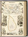
 340 of 'Other Countries ... With maps and illustrations' (11247085876).jpg 1,298 × 1,480; 255 KB
-
 Map of British Settlements in the Malay Peninsula and Coast of Borneo and Ceylon.jpg 1,519 × 1,997; 599 KB
-

-

-

-
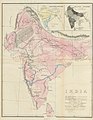
 India and Inner Asia.jpg 1,393 × 1,130; 396 KB
-
 Die Gartenlaube (1883) b 175.jpg 595 × 1,009; 243 KB
-

-
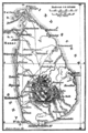 Meyers b3 s0913 b1.png 378 × 568; 89 KB
-

-
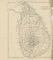
 Map of Ceylon (1888).jpg 1,219 × 1,929; 1.28 MB
-
 Mahāvihāra on 1890 map of Anuradhapura.svg 622 × 888; 394 KB
-

-

-
 495 of 'Two Happy Years in Ceylon ... Illustrated by the author' (11217198403).jpg 3,532 × 4,043; 2.62 MB
-

-

-

-

-

-

-
 Admiralty Chart No 828 Cape Comorin to Cocanada, Published 1877, Large Corrections 1898.jpg 10,883 × 16,231; 64.12 MB
-

_(cropped).jpg)


_(14596037500).jpg)
.jpg)
.jpg)
.jpg)
.jpg)
.jpg)
.jpg)

)%27_(11126956706).jpg)
)%27_(11122280494).jpg)
.jpg)

_b_175.jpg)
.jpg)

.jpg)
.jpg)

.jpg)
.jpg)
.jpg)
.jpg)
.jpg)
.jpg)
.jpg)

_(14595320809).jpg)

_(14780362064).jpg)
.jpg)