Category:19th-century maps of Andalusia
Jump to navigation
Jump to search
Autonomous communities of Spain: Andalusia · Balearic Islands · Canary Islands · Catalonia · Autonomous cities:
Media in category "19th-century maps of Andalusia"
The following 62 files are in this category, out of 62 total.
-

-

-
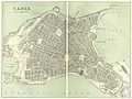 O'SHEAS (1895) p218 CADIZ.jpg 4,832 × 3,637; 8.65 MB
-
 O'SHEAS (1895) p305 GRANADA.jpg 1,161 × 1,832; 1.19 MB
-
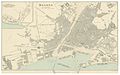 O'SHEAS (1895) p454 MALAGA.jpg 3,149 × 1,965; 3.35 MB
-
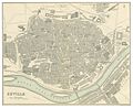 O'SHEAS (1895) p526 SEVILLE.jpg 2,335 × 1,912; 2.44 MB
-
 Plano de Valdepeñas de Jaén en 1895.jpg 7,370 × 5,381; 3.53 MB
-
 1899 map - Karte der Sierra Nevada.jpg 8,345 × 6,065; 7.42 MB
-
-

-

-

-
 320 of '(A Treatise on Earthy and other Minerals and Mining.)' (11194163934).jpg 2,000 × 1,258; 398 KB
-

-

-

-
-

-

-

-
-
 A.M.A. Raoul, Plan hydrographique de la Baie de Cadiz (FL147398332 2470921).jpg 5,888 × 3,954; 20.48 MB
-
 Actes de la Société linnéenne de Bordeaux BHL16211260.jpg 2,368 × 2,683; 748 KB
-
 Admiralty Chart No 2717 Gibraltar to Alicante and Cape Spartel to Cape Ferrat, Published 1878.jpg 16,212 × 11,083; 58.88 MB
-
 Admiralty Chart No 773 Gibraltar to Adra, Published 1895.jpg 16,169 × 11,089; 44.49 MB
-
 Andalucia-Carte-des-Routes-Didot.jpg 850 × 657; 180 KB
-

-
 Betica.jpg 842 × 619; 192 KB
-

-
 Bulletin de la Société géologique de France (1888) (20430048402).jpg 2,912 × 2,079; 1.81 MB
-
 Cadiz 1625.jpg 713 × 1,170; 145 KB
-
 Carpenter Porcupine 1871 Chart 2 02398928 0079.jpg 6,284 × 5,189; 5.06 MB
-

-

-
 Die meerenge von Gibraltar - von A. Petermann ; alt u. Stichart sculp. - btv1b53193064k.jpg 5,660 × 4,698; 4.35 MB
-
 El túnel bajo el Estrecho de Gibraltar, 1883.jpg 757 × 962; 327 KB
-
 FMIB 43868 Straits of Gibraltar.jpeg 861 × 839; 302 KB
-

-
-

-

-

-
 Map of Gibraltar Bay (1803).png 2,510 × 3,471; 7.23 MB
-

-
 Mapa itinerario del distrito militar de Andalucia - btv1b53098808c.jpg 10,673 × 8,769; 11.02 MB
-
 Mapa itinerario del Distrito militar de Granada - btv1b53098807x.jpg 10,889 × 8,301; 10.74 MB
-
 MapaRomano-Golfo de Cádis.jpg 466 × 593; 99 KB
-
 O'SHEAS (1899) p243 CORDOVA.jpg 2,532 × 1,935; 1.42 MB
-
 Peninsula española - por Don Francisco Coello - btv1b53066950m (2 of 2).jpg 16,397 × 7,302; 19.27 MB
-

-
 Plano de Cadiz y Extramuros - Grab. J. Dominguez - btv1b531930634.jpg 6,140 × 3,238; 3.05 MB
-

-
 Plano de Estepona 1889.jpeg 600 × 430; 303 KB
-
 Plano de Fuengirola 1889.jpeg 2,216 × 3,232; 4.93 MB
-
 Plano de Marbella 1889.jpeg 790 × 370; 379 KB
-
 Plano de Torremolinos 1889.jpeg 494 × 484; 205 KB
-

-
 Atlas de l'Itineraire descriptif de l'Espagne 1808 (131428186).jpg 2,496 × 3,656; 7.55 MB
-
 Atlas de l'Itineraire descriptif de l'Espagne 1808 (131428198).jpg 2,482 × 3,652; 7.28 MB
-
 Atlas de l'Itineraire descriptif de l'Espagne 1808 (131428213).jpg 4,951 × 3,668; 14.7 MB
-
 Atlas de l'Itineraire descriptif de l'Espagne 1808 (131428227).jpg 4,942 × 3,642; 15.12 MB
-
 Atlas de l'Itineraire descriptif de l'Espagne 1808 (131428238).jpg 2,449 × 3,647; 7.57 MB
.jpg)
.jpg)
_p218_CADIZ.jpg)
_p305_GRANADA.jpg)
_p454_MALAGA.jpg)
_p526_SEVILLE.jpg)


.jpg)
.jpg)
.jpg)
.jpg)
%27_(11194163934).jpg)
.jpg)
.jpg)
.jpg)
.jpg)
.jpg)
%27_(11260223744).jpg)
.jpg)
_(14595238117).jpg)
.jpg)


_-_btv1b530276479.jpg)


_(20430048402).jpg)


_-_btv1b8439792b.jpg)


_(14769325852).jpg)
_(14582446899).jpg)
.jpg)
.jpg)
_(14760895671).jpg)
.png)
.jpg)


_p243_CORDOVA.jpg)
.jpg)


.jpg)
.jpg)
.jpg)
.jpg)
.jpg)