Category:1990s maps of Canada
Jump to navigation
Jump to search
Countries of the Americas: Argentina · The Bahamas · Bolivia · Brazil · Canada · Colombia · Costa Rica · Cuba · Ecuador · Guyana · Haiti · Mexico · Nicaragua · Panama · Paraguay · Peru · Saint Kitts and Nevis · Saint Vincent and the Grenadines · Suriname · United States · Uruguay · Venezuela
Other areas: Aruba · Bermuda · French Guiana · Greenland
Other areas: Aruba · Bermuda · French Guiana · Greenland
Provinces and territories of Canada: British Columbia · Manitoba · New Brunswick · Newfoundland and Labrador · Nova Scotia · Ontario · Prince Edward Island · Quebec · Saskatchewan · Northwest Territories · Nunavut · Yukon
Subcategories
This category has the following 20 subcategories, out of 20 total.
1
B
M
N
O
P
Q
S
Y
Media in category "1990s maps of Canada"
The following 3 files are in this category, out of 3 total.
-
Charlottetown Accord referendum results map (Referendum 1992, MCR 0122).jpg 7,877 × 6,939; 7.79 MB
-
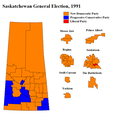
SKElection1991.png 863 × 816; 39 KB
-
Yukon Territorial Election 1992 - Results by Riding.svg 2,321 × 1,766; 309 KB


