Category:1957 maps of Africa
Jump to navigation
Jump to search
Media in category "1957 maps of Africa"
The following 8 files are in this category, out of 8 total.
-
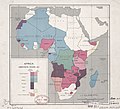 Africa, administrative divisions, 1957. LOC 97687635.jpg 4,588 × 4,158; 2.39 MB
-
 Africa, administrative divisions, 1957. LOC 97687635.tif 4,588 × 4,158; 54.58 MB
-
 African Cup of Nations 1957-(1).png 360 × 392; 4 KB
-
 African Cup of Nations Sudan 1957.png 360 × 392; 4 KB
-
 African-Cup-of-Sudan-1957.png 360 × 392; 6 KB
-
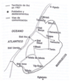 Mapa de Ifni en 1957. p. 149.png 651 × 741; 517 KB
-
 Southern Sudan - parlimentary constituencies - 1957 LOC 2019589296.jpg 10,585 × 6,647; 7.24 MB
-
 Southern Sudan - parlimentary constituencies - 1957 LOC 2019589296.tif 10,585 × 6,647; 201.3 MB

.png)


