Category:1948 maps of Iran
Jump to navigation
Jump to search
Media in category "1948 maps of Iran"
The following 14 files are in this category, out of 14 total.
-
-
 Guide map of city of Tehran, 1948.jpg 10,500 × 8,300; 12.88 MB
-
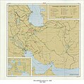
 Iran - DPLA - 0b841f02f6809e208ed95f9d46a02222.jpg 10,076 × 8,829; 5.33 MB
-
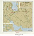
 Iran - DPLA - d110b980639f712706fd13b89ca2c07b.jpg 10,240 × 8,820; 6.6 MB
-
 Iran - DPLA - da3570e3660038bc2437ff34e67b1fe8.jpg 10,217 × 8,833; 5.84 MB
-
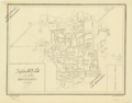
 Map of Ardabil, 1948.jpg 6,312 × 6,136; 3.91 MB
-
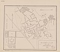
 Map of Bujnurd, 1948.jpg 7,260 × 6,710; 4.28 MB
-
 Map of Rezaiyeh, 1948.jpg 1,646 × 1,259; 1.86 MB
-
 Map of Sabzevar, 1948.png 8,725 × 6,855; 71.46 MB
-
 Map of Tabriz, 1948.jpg 10,332 × 7,103; 8.26 MB
-
 Map of Torbat-e Heydarieh, 1948.jpg 6,116 × 7,870; 3.51 MB
-
 Map of Torbat-e Jam, 1948.jpg 7,614 × 6,503; 3.92 MB
-
 Map of Turbat-i-jam, 1948.jpg 7,642 × 6,602; 3.84 MB
-
 Soviet Agencies In Iran - DPLA - 75a8bc61c98e9fb3b2feb94dbddfd026.jpg 5,784 × 6,111; 3.98 MB
_-_DPLA_-_f638d515a91728bff66e54a61946d522.jpg)


