Category:1930s maps of the Caucasus
Jump to navigation
Jump to search
Media in category "1930s maps of the Caucasus"
The following 7 files are in this category, out of 7 total.
-
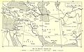
 Near East & India 1930, svatlas cropped.jpg 882 × 637; 345 KB
-
 Этнографическая карта Кавказа — II; IV (1928–1930).jpg 20,024 × 16,284; 35.2 MB
-
 Pictorial Map of the Caucasus.jpg 7,257 × 5,191; 9.04 MB
-
 КАВКАЗ~КРЫМ~СССР~1939~USSR~CAUCASUS~CRIMEA~.jpg 4,327 × 2,744; 4.47 MB
-
 Železnice v Západní Asii.jpg 2,828 × 1,771; 796 KB
-
 PERSIA (Adserbeidyan, Nagichevan)-1~4.jpg 3,933 × 2,739; 3.3 MB
-
 TurquíaPalestinaSiriaIrakTransjordaniaCáucaso 1939.jpg 4,000 × 3,000; 1.42 MB

.jpg)


-1~4.jpg)