Category:1901 maps
Jump to navigation
Jump to search
| ← · 1900 · 1901 · 1902 · 1903 · 1904 · 1905 · 1906 · 1907 · 1908 · 1909 · → |
Deutsch: Karten mit Bezug zum Jahr 1901
English: Maps related to the year 1901
Español: Mapas relativos al año 1901
Français : Cartes concernant l’an 1901
Русский: Карты 1901 года
Subcategories
This category has the following 11 subcategories, out of 11 total.
Media in category "1901 maps"
The following 92 files are in this category, out of 92 total.
-
 Obstbau-Karte des Herzogtums Sachsen-Altenburg 1901.jpg 3,507 × 2,480; 4.28 MB
-
 1901 Brockton & Plymouth Street Railway map.png 3,500 × 928; 7.64 MB
-
 1901 Map of Martin Drive Neighborhood, Milwaukee, Wisconsin USA.jpg 2,048 × 1,536; 357 KB
-
 1901 Traveler's Map of Eastern New England.png 3,159 × 4,327; 22.59 MB
-

-

-
 Abkhazia in the Map of Caucasus with the borders 1801-1813.JPG 939 × 686; 641 KB
-
 Abwasserkanäle von Wien 1901.jpg 5,451 × 4,824; 24.05 MB
-
 Akragas-map-1901.jpg 1,194 × 1,458; 531 KB
-
 Alaska Canada 1901.jpg 9,351 × 6,885; 8.34 MB
-
 Aneityum 1901 Nautical Chart (cropped).jpg 5,345 × 5,172; 5.92 MB
-
 Aneityum 1901 Nautical Chart.jpg 9,316 × 7,710; 15.05 MB
-

-

-
 Baol-Géologie.jpg 1,285 × 737; 186 KB
-
 Chambers's encyclopaedia; a dictionary of universal knowledge (1901) (14743496146).jpg 3,600 × 2,214; 743 KB
-
 Berlin 1905 Meyers Konversationslexikon 6. Auflage; Berlin-Reinickendorf (cropped).jpg 1,948 × 1,261; 1.38 MB
-
 Bermuda Islands 1901 atlas page.jpg 5,958 × 4,532; 6.65 MB
-
 Biesenthal map 1901.jpg 1,860 × 1,239; 1.28 MB
-
 Binghamton, N.Y. 1901. LOC 75694747.jpg 17,280 × 12,768; 45.55 MB
-
 Brit Ashanti 1900.png 4,775 × 5,552; 5.85 MB
-
 Brunkelburg Skizze.png 263 × 276; 28 KB
-
 Bucovina.JPG 987 × 1,285; 615 KB
-
 Castle Hewen.jpg 1,122 × 821; 178 KB
-
 Chiragan fouilles plan Joulin.jpg 3,878 × 2,527; 821 KB
-
 Conway Reef 1901 (Ceva-i-Ra) Nautical Chart.jpg 1,473 × 1,300; 468 KB
-
 Croatia, Bosnia, Serbia and Montenegro religious demographics map, 1901.png 1,043 × 811; 395 KB
-
 Cvtimetable1901june231901page1.jpg 3,694 × 1,863; 1.7 MB
-
 Darling Harbour Resumptions.jpg 1,381 × 873; 298 KB
-
 Digest of Game Laws for 1901 (1901) (14783984155).jpg 4,259 × 2,512; 660 KB
-
 Environs d'Amiens - 1901.jpg 6,969 × 8,014; 9.52 MB
-
 Feb-1901-OGw.jpg 330 × 500; 171 KB
-
 French Service géographique de l'armée, Fez (FL13720556 2367084).jpg 10,539 × 8,281; 135.46 MB
-
 Frontier of NY in Revolution German Flatts Attack.jpg 3,245 × 2,310; 1.21 MB
-
 Futuna (Vanuatu) 1901 Nautical Chart.jpg 2,224 × 1,946; 1.14 MB
-
-
 Gewesteter Ortsbauplan von Heilbronn-Böckingen 1901.jpg 2,095 × 1,200; 398 KB
-
 Histoire du bouddhisme dans l'Inde, t2, carte.jpg 938 × 1,436; 556 KB
-
 Historical Birds-Eye View of the Holy Land (FL7330931 2633465).jpg 6,968 × 4,480; 47.69 MB
-
 Historical Birds-Eye View of the Holy Land (FL7330933 2633465).jpg 6,984 × 4,512; 51.27 MB
-
 Jerusalem (FL45593386 3931766).jpg 3,889 × 3,083; 3.22 MB
-

-
 Karta Manʹchzhurīi LOC 2019585142.jpg 9,137 × 7,465; 9.77 MB
-
 Karta Manʹchzhurīi LOC 2019585142.tif 9,137 × 7,465; 195.14 MB
-
 Karta puteĭ soobshchenīi︠a︡ Azīatskoĭ Rossīi LOC 99447692.jpg 21,431 × 9,681; 41.57 MB
-
 Karta puteĭ soobshchenīi︠a︡ Azīatskoĭ Rossīi LOC 99447692.tif 21,431 × 9,681; 593.59 MB
-
 Khanates.jpg 2,271 × 1,661; 3.26 MB
-
 Krimmelburg Skizze.png 228 × 252; 20 KB
-
 Kurinskoe khanstvo in the Map of Caucasus with the borders 1801-1813.png 708 × 465; 707 KB
-
 Kursk (Kulzinsky).jpg 4,724 × 5,289; 12.68 MB
-
 Lake Erie historical map, 1901 - DPLA - 94a2d4b0d5bd2a5b21428b55acec7eab.jpg 8,999 × 6,098; 5.14 MB
-
 Map Brit Ashanti 1900.jpg 4,775 × 5,552; 4.68 MB
-
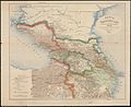 Map of Caucasus with the borders 1801-1813.JPG 4,936 × 4,049; 7.92 MB
-
 Map of Ohio, Monongalia, & Yohogania Counties.jpg 1,002 × 1,160; 199 KB
-
 Map of the city of Quincy, Norfolk County (2675040264).jpg 1,875 × 2,000; 2.94 MB
-
 Map of Trinity Bay, Telegraph Station of the Atlantic-Cable. LOC 98686087.jpg 9,640 × 6,456; 9.42 MB
-
 Map of Trinity Bay, Telegraph Station of the Atlantic-Cable. LOC 98686087.tif 9,640 × 6,456; 178.06 MB
-
 Mapa de la República de Bolivia (2675762582).jpg 1,635 × 2,000; 2.83 MB
-
 Matthew and Hunter Islands 1901 Nautical Chart (part).jpg 3,136 × 1,936; 1.04 MB
-
 McMillan Plan.jpg 1,050 × 678; 343 KB
-
 New York 1901.jpg 5,416 × 9,675; 6.62 MB
-

-

-
 Port Inyeug 1901 US Nautical Chart (part).jpg 3,722 × 7,077; 5.86 MB
-

-

-
 PragueTramvayTrafficYear1901.jpg 1,451 × 1,087; 871 KB
-
 PSM V58 D324 Northern hemispheric view of our galaxy.png 1,568 × 1,557; 526 KB
-
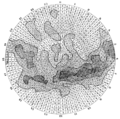 PSM V58 D325 Southern hemispheric view of our galaxy.png 1,570 × 1,555; 478 KB
-
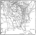
 PSM V58 D396 Cyclone chart of sept 18 1900 at 8am.png 1,437 × 1,318; 226 KB
-
 PSM V58 D397 Cyclone pattern and changing temperatures of nov 22 1898.png 1,464 × 1,439; 302 KB
-
 PSM V58 D398 Cyclone pattern following the sun.png 1,442 × 1,429; 213 KB
-
 PSM V58 D399 Summer hurricane patterns over eastern us.png 1,452 × 1,211; 206 KB
-
 Puerto Rico5176452095901150710.jpg 9,208 × 5,942; 13.42 MB
-
 Q1768171, Dead Sea and eastern region (FL45588589 3929600).jpg 3,396 × 4,721; 3.24 MB
-
 Queens V. 4, Plate No. 10 (Map bounded by Cleveland Ave., Grant Ave., Jamaica Ave.) NYPL1955002.tiff 5,412 × 7,216, 2 pages; 111.79 MB
-
 Queens V. 4, Plate No. 11 (Map bounded by Cleveland Ave., Cherry, Jamaica Ave., Grant Ave.) NYPL1955003.tiff 5,412 × 7,216, 2 pages; 111.79 MB
-
 Queens V. 4, Plate No. 8 (Map bounded by Cleveland Ave., Jamaica Ave., Wookhaven Ave., Ferris) NYPL1955000.tiff 5,412 × 7,216, 2 pages; 111.79 MB
-
 Reitling Vorwerk.gif 281 × 391; 43 KB
-
 Reitlingstal Skizze.png 849 × 561; 97 KB
-
 Salmon Canneries of the Pacific Northwest. LOC 99446194.tif 5,346 × 6,782; 103.73 MB
-

-
 Spain and Portugal- handbook for travellers (1901) (14776280302).jpg 2,000 × 1,336; 957 KB
-
 Spezialkarte der Österreichisch-ungarischen Monarchie - Görz und Gradisca 1901.jpg 12,900 × 9,264; 28.12 MB
-
 Spezialkarte der Österreichisch-ungarischen Monarchie - Prassberg a. d. Sann 1901.jpg 14,627 × 11,428; 36.28 MB
-
 Spezialkarte der Österreichisch-ungarischen Monarchie - Triest 1901.jpg 12,886 × 9,228; 20.81 MB
-
 St George's Town and St George's Garrison , Bermuda OS Map Lieut AJ Savage 1901.jpg 2,823 × 1,735; 911 KB
-
 The country around Jerusalem (FL45593393 3931776).jpg 2,002 × 3,504; 2.36 MB
-
 Vandali.jpg 1,477 × 2,032; 2.56 MB
-
 Walpole Island 1901 US Nautical Chart (part).jpg 1,030 × 1,925; 421 KB
-
 Wendehai Skizze.png 227 × 208; 11 KB
-
 Wurtgarten.png 242 × 226; 19 KB


.jpg)

_(14803058153).jpg)

_(14743496146).jpg)
.jpg)


_Nautical_Chart.jpg)


_(14783984155).jpg)


.jpg)

_1901_Nautical_Chart.jpg)


.jpg)
.jpg)
.jpg)


.jpg)


.jpg)

.jpg)
.jpg)


.jpg)
_of_the_Navy_by_condemnation,_proceedings_for_naval_purposes_at_Pearl_Harbor,_Hawaii_LOC_2002622183.jpg)


.jpg)


.jpg)
_(14776280302).jpg)


.jpg)

.jpg)


_(14782556934).jpg)