Category:1879 maps
Jump to navigation
Jump to search
| ← · 1870 · 1871 · 1872 · 1873 · 1874 · 1875 · 1876 · 1877 · 1878 · 1879 · → |
Deutsch: Karten mit Bezug zum Jahr 1879
English: Maps related to the year 1879
Español: Mapas relativos al año 1879
Français : Cartes concernant l’an 1879
Русский: Карты 1879 года
Subcategories
This category has the following 11 subcategories, out of 11 total.
Media in category "1879 maps"
The following 158 files are in this category, out of 158 total.
-
 (Shanxi sheng cheng jie dao ji fu jin tan miao cun zhuang tu) LOC gm71005056.jpg 7,798 × 11,604; 10.43 MB
-
 (Shanxi sheng cheng jie dao ji fu jin tan miao cun zhuang tu) LOC gm71005056.tif 7,798 × 11,604; 258.89 MB
-

-
-
 (1879) MAP OF CROATIA, SLAVONIA, DALMATIA & 'MILITÄRGRENZE' of AUSTRIAN EMPIRE.jpg 5,109 × 5,033; 10.02 MB
-
 (1879) PATAGONIA.jpg 4,369 × 2,421; 5.17 MB
-
 (1879) Map of the Hill of Tara.jpg 2,178 × 2,783; 1.06 MB
-
 COMBAT NAVAL DE IQUIQUE - 1879.jpg 2,267 × 3,287; 3.22 MB
-
 1879 CV excursion routes.jpg 3,288 × 3,991; 3.93 MB
-
 1879 CV map only.jpg 1,860 × 2,688; 1.54 MB
-
 1879 CV White Mountains.jpg 2,314 × 1,790; 1,017 KB
-
 1879 CV.jpg 3,968 × 3,216; 3.19 MB
-

-
 1879 map of Seymour, Connecticut.jpg 4,000 × 3,187; 3.54 MB
-

-
 1879 Plan de ChCh.jpg 1,331 × 1,025; 453 KB
-
 1879 Portland & Ogdensburg map only.jpg 2,995 × 2,004; 1.65 MB
-
 1879 Portland & Ogdensburg White Mountains.jpg 4,515 × 4,753; 5.68 MB
-
 1879 Portland & Ogdensburg.jpg 4,717 × 4,517; 5.45 MB
-
 Afghanistan - a map LOC 2004629229.jpg 6,963 × 6,531; 10.46 MB
-
 Afghanistan - a map LOC 2004629229.tif 6,963 × 6,531; 130.11 MB
-
 AmCyc Park - Map of Victoria Park.jpg 2,428 × 1,006; 395 KB
-
 Annali del Museo civico di storia naturale di Genova (1879) (18412482751).jpg 3,454 × 2,984; 1.41 MB
-
 Archives des missions scientifiques et littéraires (1879) (19566670419).jpg 2,508 × 3,356; 1.09 MB
-
-

-
 Australia - Map 1879.jpg 3,344 × 2,560; 5.35 MB
-

-

-
 Bulletin de la Société zoologique de France (1879) (20442232081).jpg 3,153 × 1,528; 795 KB
-
 Cape Cod Bay (8347571122).jpg 800 × 649; 91 KB
-
 Carta de los Desiertos de Tarapacá y de Atacama 1879.jpg 714 × 1,024; 165 KB
-
-

-
 Carte topographique du département de Meurthe-et-Moselle - 1879.jpg 18,948 × 18,426; 83.02 MB
-
 Centre Old Luhansk Map 1879.jpg 1,840 × 2,282; 3.1 MB
-
 Chōsenkoku Gazankō ryakuzu - Sanmanbun no ichi LOC 2010360473.jpg 11,363 × 10,584; 12.04 MB
-
 Chōsenkoku Gazankō ryakuzu - Sanmanbun no ichi LOC 2010360473.tif 11,363 × 10,584; 344.08 MB
-
 Demiokhina - Centre Old Luhansk Map 1879.jpg 1,840 × 2,282; 2.9 MB
-
 Die Gartenlaube (1879) b 569.jpg 2,263 × 1,571; 474 KB
-
 Dimmit County. LOC 2012590158.jpg 7,497 × 6,520; 6.17 MB
-
 Dimmit County. LOC 2012590158.tif 7,497 × 6,520; 139.85 MB
-
 EB9 Göttingen - plan.jpg 1,261 × 1,324; 337 KB
-
 Eglise Toussaints 1879 Musée de Bretagne 920.42.1.jpg 1,024 × 751; 276 KB
-

-
-
 Flammarion - La planète Mars, Tome 1-f180.jpg 760 × 400; 76 KB
-
 Flammarion - La planète Mars, Tome 1-f185.jpg 2,394 × 1,238; 948 KB
-
 Guia del plano de Madrid y sus contornos en 1877.jpg 3,600 × 3,916; 4.11 MB
-
 Hiawatha, Kansas, 1879 LOC 2013591257.jpg 7,139 × 5,294; 6.11 MB
-
 Hiawatha, Kansas, 1879 LOC 2013591257.tif 7,139 × 5,294; 108.13 MB
-
 Hillel Kahane, מפה מכדור הארץ (FL147393844 2534304).jpg 4,143 × 3,317; 10.44 MB
-
 Hillel Kahane, מפה מכדור הארץ (FL169299081 3488462).jpg 9,974 × 7,477; 85.24 MB
-
 Holbrook's map of the city of Newark, New Jersey. LOC 2011593697.jpg 7,780 × 5,786; 8.17 MB
-
 Holbrook's map of the city of Newark, New Jersey. LOC 2011593697.tif 7,780 × 5,786; 128.79 MB
-
 In dreissig Tagen durch die Schweiz1.jpg 5,029 × 3,996; 2.99 MB
-
 Index map of the city of Louisville, Ky. LOC 79691615.jpg 7,314 × 5,186; 6.02 MB
-
 Index map of the city of Louisville, Ky. LOC 79691615.tif 7,314 × 5,186; 108.52 MB
-
 Indexed map of New Mexico showing stage lines, counties lake & rivers. LOC 98688517.jpg 3,936 × 6,032; 6.26 MB
-
 Ireland, the 3rd Parish of West Springfield, Holyoke (1827).png 3,904 × 2,597; 13.35 MB
-
 Isleta-peninsula-Gran-Canaria-Old-Map-1879.jpg 1,445 × 1,934; 1.49 MB
-
 J. Schedlers relief map of the White Mountains, N.H (9475477430).jpg 610 × 800; 134 KB
-
 Jacob's 1878 official map of Prince Edward County, Virginia LOC 2012592122.jpg 9,605 × 7,439; 7.33 MB
-
 Jacob's 1878 official map of Prince Edward County, Virginia LOC 2012592122.tif 9,605 × 7,439; 204.42 MB
-

-
 Kepa Potocka island map Warsaw 1879.jpg 1,113 × 835; 883 KB
-
 Kreis Schwetz im Regierungs-Bezirke Marienwerder 1879.jpg 10,543 × 10,369; 46.28 MB
-
 La Terra Santa (FL36567559 3914256).jpg 2,786 × 3,981; 6.47 MB
-
 Messtischblatt 4640 Leipzig von 1879 df dk 0000093.jpg 7,715 × 7,615; 14.55 MB
-
 Lugar de Baixo, António Pedro de Azevedo, 1879.jpg 705 × 597; 124 KB
-
 Map illustrating the travels of St. Paul (FL35098751 3892576).jpg 8,600 × 6,366; 79.16 MB
-
 Map of Barren Co., Kentucky LOC 2012593100.jpg 11,828 × 15,148; 20.7 MB
-
 Map of Barren Co., Kentucky LOC 2012593100.tif 11,828 × 15,148; 512.61 MB
-
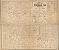 Map of Cedar Co. Missouri LOC 2012593075.jpg 16,473 × 13,989; 28.25 MB
-
 Map of Cedar Co. Missouri LOC 2012593075.tif 16,473 × 13,989; 659.3 MB
-
-

-
 Map of Jefferson County, Georgia LOC 2012593668.jpg 8,438 × 12,246; 13.55 MB
-
 Map of Jefferson County, Georgia LOC 2012593668.tif 8,438 × 12,246; 295.63 MB
-
 Map of Montgomery County, Kentucky LOC 2012593097.jpg 9,884 × 13,483; 15.75 MB
-
 Map of Montgomery County, Kentucky LOC 2012593097.tif 9,884 × 13,483; 381.28 MB
-
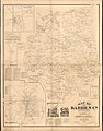
 Map of Scott Co., Kentucky LOC 2012593095.jpg 9,567 × 15,265; 17.61 MB
-
 Map of Scott Co., Kentucky LOC 2012593095.tif 9,567 × 15,265; 417.82 MB
-
 Map of Steele County, Minnesota - drawn from actual surveys and the county records. LOC 2012593069.jpg 13,649 × 15,144; 26.97 MB
-
 Map of Steele County, Minnesota - drawn from actual surveys and the county records. LOC 2012593069.tif 13,649 × 15,144; 591.38 MB
-
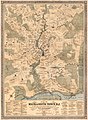
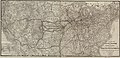
 Map of the Chicago, Burlington and Quincy R.R. LOC 98688624.jpg 12,911 × 8,625; 20.71 MB
-
 Map of the Chicago, Burlington and Quincy R.R. LOC 98688624.tif 12,911 × 8,625; 318.6 MB
-

-

-

-
-
 Map of the environs of Jerusalem (FL35098680 3892587).jpg 8,697 × 6,358; 74.48 MB
-

-

-

-
 Map of the scripture world.giving distances from Jerusalem (FL35098695 3892622).jpg 8,569 × 6,309; 78.57 MB
-
 Map of Walker's Mtn. land LOC 2005625198.jpg 10,633 × 3,865; 5.26 MB
-
 Map of Walker's Mtn. land LOC 2005625198.tif 10,633 × 3,865; 117.58 MB
-
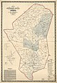
 Map of Whitfield County, Georgia LOC 2010592396.jpg 6,863 × 8,865; 8.15 MB
-
 Map of Whitfield County, Georgia LOC 2010592396.tif 6,863 × 8,865; 174.07 MB
-

-
-

-

-

-

-

-

-
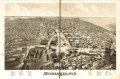
 Milwaukee, Wis. 1879. LOC 75696716.jpg 12,656 × 8,384; 22.09 MB
-
 Milwaukee, Wis. 1879. LOC 75696716.tif 12,656 × 8,384; 303.58 MB
-
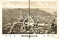 Milwaukee1879.jpg 12,656 × 8,384; 22.03 MB
-
-
 Norfolk Island chart 1879 by Henry Mangles Denham.png 6,230 × 8,552; 43.64 MB
-
 Nouveau Paris monumental - itinéraire pratique de l'étranger dans Paris - Flickr.jpg 2,000 × 1,538; 3.45 MB
-
 Nueces County. LOC 2012590093.tif 11,641 × 9,015; 300.25 MB
-
 O. D. Case, Ancient Jerusalem (FL36567562 3915801).jpg 2,994 × 2,372; 3.53 MB
-
 O. D. Case, Modern Palestine (Physical) (FL36567590 3915803).jpg 2,271 × 3,095; 3.36 MB
-
 O. D. Case, The kingdoms of Judah and Israel during the monarchy (FL36567568 3915781).jpg 2,261 × 2,992; 3.38 MB
-
 O. D. Case, The United kingdom of of Saul, David and Solomon (FL36567565 3915784).jpg 2,317 × 3,050; 3.12 MB
-

-

-
 Panoramic view of the city of Minneapolis, Minnesota, 1879. LOC 75694642.jpg 10,352 × 6,512; 13.18 MB
-
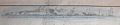 Perfil da Ilha da Madeira tirado defronte a Ponta Delgada, 1879.jpg 1,100 × 226; 35 KB
-
 Perfil da Ilha da Madeira tirado defronte ao Cabo Girão, 1876.jpg 1,100 × 326; 68 KB
-
 Plan de carreteras provinciales de Barcelona.jpg 3,193 × 4,070; 1.73 MB
-
-
 Port Phillip surveyed by Charles Grimes (1803).tif 6,570 × 7,280; 162 KB
-
 PSM V15 D169 First meridians.png 2,000 × 1,393; 213 KB
-

-

-
-
 Tarapaca 1879 Bertrand Iquique-La Noria.jpg 741 × 306; 230 KB
-

-
 Territorio ocupado en Tarapacá por el ejército chileno (1879).jpg 1,220 × 1,415; 409 KB
-
 The city of New Haven, Conn. (2674615764).jpg 2,000 × 1,441; 3.21 MB
-
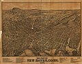 The city of New Haven, Conn. 1879. LOC 75693153.jpg 11,776 × 9,088; 18.84 MB
-
 The city of New Haven, Conn. 1879. LOC 75693153.tif 11,776 × 9,088; 306.19 MB
-
 The city of New Haven, Conn. 1879..jpg 11,658 × 8,997; 31.98 MB
-
 The Helmund River. LOC 2006627703.jpg 4,420 × 5,320; 4.25 MB
-
 The Helmund River. LOC 2006627703.tif 4,420 × 5,320; 67.28 MB
-
 The Hindu Kush and passes between the Kabul and Oxus. LOC 2006627701.jpg 5,385 × 3,607; 4.36 MB
-
 The Hindu Kush and passes between the Kabul and Oxus. LOC 2006627701.tif 5,385 × 3,607; 55.57 MB
-

-

-
 United States Caribbean change 1879-09-08.png 2,046 × 1,321; 187 KB
-
 View of Bethel, Conn. (2675971024).jpg 2,000 × 1,559; 2.75 MB
-
 View of Bethel, Conn. LOC 88694060.jpg 7,848 × 6,159; 10.48 MB
-
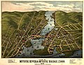 View of Mystic River & Mystic Bridge, Conn. 1879. LOC 74693238.jpg 7,776 × 6,080; 10.84 MB
-
 View of Seymour, Conn. (2673846357).jpg 2,000 × 1,577; 2.62 MB
-
 View of Seymour, Conn. 1879. LOC 74693230.jpg 7,712 × 6,144; 8.54 MB
-
 View of Seymour, Conn. 1879. LOC 74693230.tif 7,712 × 6,144; 135.56 MB
-
-
 TK25 Sachsen Äquidistantenkarte Montage Leipziger Gewässerknoten und Elsteraue 1880.jpg 7,440 × 10,680; 25.86 MB
-
 Zwenkau Alte Elster und Altes Elsterwehr Fischerwinkel Mückenhaynwiese Döhlen 1880.jpg 1,214 × 1,578; 1.04 MB
-
 Zwenkau Messtischblatt df dk 0000151 4739 1879.jpg 7,708 × 7,746; 8.76 MB
-
 План Луганска 1879.jpg 8,872 × 4,494; 13.35 MB
-

-
_LOC_gm71005056.jpg)
.jpg)
_-_Geographicus_-_NYC33Miles-colton-1879.jpg)
_MAP_OF_CROATIA,_SLAVONIA,_DALMATIA_%26_%27MILIT%C3%84RGRENZE%27_of_AUSTRIAN_EMPIRE.jpg)
_PATAGONIA.jpg)
_Map_of_the_Hill_of_Tara.jpg)


_-_Geographicus_-_America-meiji12-1879.jpg)


_(18412482751).jpg)
_(19566670419).jpg)


_(20442232081).jpg)
.jpg)

_de_Ant%C3%B3nio_Pedro_de_Azevedo,_1879.jpg)


_b_569.jpg)


_-_geh%C3%B6rt_wahrscheinlich_zu_seinem_1509_herausgegeben_Buch_%22Globus_mundi%27_;_Zweiter_gedruckter_Globus,_Peter_Apianus_-_in_dessen_LOC_2009582745.jpg)


.jpg)
.jpg)


.png)

.jpg)

,_RP-P-OB-89.268.jpg)


.jpg)


.jpg)


.jpg)

.jpg)


.jpg)


.jpg)
_(FL36567590_3915803).jpg)
.jpg)
.jpg)


.jpg)
.jpg)


,_near_Tennallytown_-_about_1879%3F_-_(Washington_D.C.)._LOC_88693133.jpg)

.jpg)


.jpg)

.png)


.jpg)
.jpg)