Category:17th-century maps of Paraguay
Jump to navigation
Jump to search
Subcategories
This category has the following 2 subcategories, out of 2 total.
Media in category "17th-century maps of Paraguay"
The following 23 files are in this category, out of 23 total.
-
 Atlas ou Representation du Monde Universel t. 2. 1633 (110103072).jpg 16,509 × 12,037; 31.9 MB
-
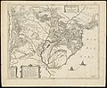
 Le Paraguayr, Le Chili, La Terre, et les Isles Magellanicques.jpg 2,000 × 1,480; 2.63 MB
-

-

-
 AMH-8647-NA Map of part of South America.jpg 2,400 × 2,005; 557 KB
-
 AMH-8648-NA Map of Paraguay.jpg 2,400 × 2,049; 758 KB
-
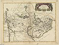
 Atlas Van der Hagen-KW1049B13 091-PARAQVARIA Vulgo PARAGUAY, Cum adjacentibus.jpeg 5,500 × 4,458; 3.69 MB
-

-
-
 Le Paraguay tiré des relations les plus récentes - par G. Sanson - btv1b85966600.jpg 8,832 × 6,587; 9.75 MB
-

-

-
 Brazill and La Plata (NYPL b14428893-1503454).jpg 5,248 × 6,299; 7 MB
-
 Paraqvaria Vulgo Paragvay Cum adjacentibus (NYPL b14467885-1505059).jpg 6,117 × 4,942; 8.16 MB
-
-

-

-

-

-

-
 Paraguayo prov. de Rio de la Plata cum regionibus adiacentibus Tucuman... - CBT 6621176.jpg 5,520 × 4,324; 5.57 MB
-
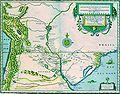
 Paraquaria vulgo Paraguay (8643436410).jpg 800 × 660; 139 KB
-
 Paraquaria vulgo Paraguay. Cum adjacentibus. R 2= 22. Pièce 71.jpg 6,704 × 4,664; 6.05 MB
.jpg)

.jpg)
.jpg)


.jpg)
_Sanson_-_btv1b531433395.jpg)


.jpg)
.jpg)

_-_btv1b8596658x_(1_of_2).jpg)


.jpg)


.jpg)
