Category:15th-century maps of the Holy Roman Empire
Jump to navigation
Jump to search
Subcategories
This category has the following 2 subcategories, out of 2 total.
*
Media in category "15th-century maps of the Holy Roman Empire"
The following 2 files are in this category, out of 2 total.
-
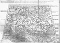 Deutschland 1450.jpg 5,973 × 4,246; 6.19 MB
-
 Älteste Deutschlandkarte.jpg 5,000 × 3,508; 4.69 MB

