
Category:14th-century maps of the Iberian Peninsula
Subcategories
This category has only the following subcategory.
S
Media in category "14th-century maps of the Iberian Peninsula"
The following 10 files are in this category, out of 10 total.
-

-
 Atlantic map from Pietro Vesconte 1321 atlas.jpg 1,007 × 1,478; 533 KB
-
 Atlantic map from Pietro Vesconte 1325 atlas.jpg 1,954 × 2,848; 2.65 MB
-
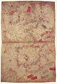
 Península Ibérica no portolano de Angelino Dulcert (original, 1339; fac-símile, 1890).jpg 1,917 × 1,384; 1.56 MB
-

-

-
 Península Ibérica no portolano de Angelino Dalorto ou Dulceto (1325 ou 1330).jpg 1,896 × 1,343; 2.06 MB
-
 Península Ibérica no portolano de Angelino Dulcert (1339).jpg 1,238 × 892; 999 KB
-
 Península Ibérica no portolano de Guillem Soler (c. 1380).jpg 3,285 × 2,590; 5.57 MB
-
 Península Ibérica no portolano de Pizigani (1367).jpg 2,094 × 1,504; 3.54 MB
.jpg)


.jpg)
_(original,_1154;_c%C3%B3pia,_c._1300).jpg)
_(original,_1154;_c%C3%B3pia,_c._1300).jpg)
.jpg)
.jpg)
.jpg)
.jpg)