User:Est. 2021/Gallery/Kievan Rus
Jump to navigation
Jump to search
 See also: Category:Maps of the history of Ukraine.
Pre-Russian era
[edit]-
Before 600 BCE.
-
From 600 to 300 BCE.
-
Map of Old Great Bulgaria, circa 650.
-
European territory inhabited by East Slavic tribes in 8th and 9th century.
-
The trade route from the Varangians to the Greeks, according to Marika Mägi (In Austrvegr: The Role of the Eastern Baltic in Viking Age Communication across the Baltic Sea, 2018).
-
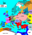
Map of Europe after the death of Charles the Great (814 AD). Original map by Charles Colbeck (The Public Schools Historical Atlas, 1905).
-
Map of Europe after the death of Charles the Great (814 AD). Corrected.
-
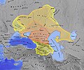
Map of the Khazar Khaganate and surrounding states, circa 820 CE. Area of direct Khazar control shown in dark blue, sphere of influence in purple. Other boundaries shown in dark red.
-
Map showing the major Varangian trade routes: the Volga trade route (in red) and the trade route from the Varangians to the Greeks (in purple). Other trade routes of the 8th to the 11th centuries shown in orange.
-
The city of Tmutarakan (Samkarsh) and its international relations during Khazar times (618-1048) and later.
Russian era
[edit]Russian Kingdoms
[edit]-
The Pontic steppes, circa 1015 (areas in blue possibly still under Khazar control).
-
Territories of the Pechenegs, circa 1030.
-
Map of later Kievan Rus' (after the death of Yaroslav I in 1054).
-
Principalities of the later Kievan Rus (after the death of Yaroslav I in 1054).
-
Map of the Kievan Rus' realm, 1015-1113 CE, of the medieval Rus' culture in Eastern Europe.
-
The Cuman–Kipchak confederation in Eurasia, c. 1200
-
Map of the Kievan Rus in 1237. The names of tribes and peoples are in bold and yellow, the names of countries outside the Kievan Rus are in bold and black. The names of principalities of the Kievan Rus are in blue.
-
The Kingdom of Galicia–Volhynia (or Kingdom of Halych-Volynia), 1245-1349. It was one of the several most important powers to emerge from the collapse of Kievan Rus'.
Russian Tsardom
[edit]-
Territorial expansion of Moscow between 1300 and 1547.
-
Russian Tsardom between 1500 and 1700.
Russian Tsardom in Ukraine
[edit]-
1654. Cossack Hetmanate, founded by the Hetman of the Zaporizhian Host, Bohdan Khmelnytsky, during the Khmelnytsky Uprising from 1648 to 1657 in the eastern territories of the Polish–Lithuanian Commonwealth. Establishment of vassal relations with the Tsardom of Russia in the Treaty of Pereyaslav of 1654 is considered a benchmark of the Cossack Hetmanate in Soviet, Ukrainian, and Russian historiography.
-
1764
-
First Novorussia governorate, 1764-1776
-
Little Russia (Malorussia) and New Russia (Novorussia) in 1800
-
Establishment of the boundaries of the Ukrainian Socialist Soviet Republic in 1917-1928.
-
Ukrainian territorial evolution, 1917-1954


