User:DutchTreat/Journal/2021
Jump to navigation
Jump to search
2021 February
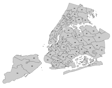
[edit]- Map of 51 councils for NYC as File:New York City Council Districts.svg (19 February)
-
NYC Council Districts
- User:Jurkij provided Czech translation File:Map of Bismarcks alliances-cs.svg of a map I translated from French into English File:Map of Bismarcks alliances-en.svg, then enhanced it. Another example of the value of the sharing economy. (19 February)
2021 March
[edit]- Created Data:New York City Council District 01.map, 10, 11, and 12, my first attempt at storing GeoJSON data into the Data namespace! (2 March)
- Created Data:New York City Council District 13.map, 14, 15, 18 and 19 (3 March)
- Created remaining Council District map series until end at 51 (8 March)
2021 May
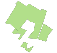
[edit]- Created Data:North America First Free Black Settlement.map to use on w:Land of the Blacks (Manhattan) (9 May)
- Created Data:Neighbourhoods/New York City/Morningside Heights Historic District.map (10 May)
- Moved Data:Historic Districts/New York City/Morningside Heights.map from Neighbourhoods top-node (31 May)
- Updated Data:North America First Free Black Settlement.map using best available sources at VillagePreservation.org; uploaded map as SVG to use on enWP with Overlay template (31 May)
-
Map of North America's First Free Black Settlement
2021 June
[edit]- Created drop of Manatus map to use on Steyvesant Farm (4 June)
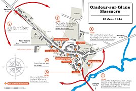
- Created "Map of Oradour-sur-Glane massacre on 10 June 1944" upon request from w:User:Mathglot (30 June, updates on 1 July)
-
Manatvs gelegen op de Noot Riuier with closeup of Numbers 01 to 17
-
Map of Oradour-sur-Glane massacre on 10 June 1944
- Start gather thoughts on architectural photography ratings systems at User:DutchTreat/Projects/nyc-buildings (30 June)
2021 July
[edit]- More on NYC buildings ratings (1 July)
- Reviewing the goals and rules for meta:Wikipedia Pages Wanting Photos 2021 running months of July and August (5 July)
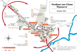
- Map in SVG for "Massacre of Oradour-sur-Glane", collbaoration with User:Ikonact (16 July)
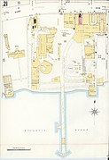
- Coney Island maps from LOC copies of Sanborn Fire Insurance Map from Brooklyn (1906) volume 13 (4 sheets) (21 July)
-
Map in SVG of "Massacre of Oradour-sur-Glane"
- Sanborn Map, Brooklyn (1906), Volume 13
-
Sheet 21 Steeplechase Park
-
Sheet 23
-
Sheet 24 Dreamland
-
Sheet 26 Luna Park
2021 August
[edit]- File:Francois d-Agincour.jpg rename request to w:Portrait of Barthélemy-Jean-Claude Pupil (3 August)
- Map of Dreamland Park in 1906 from Sanborn Maps, v. 13, merged sheets 23-24 (5 August)
-
Map of Dreamland Park, Coney Island, Brooklyn, New York in 1906
2021 September
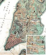
[edit]- Map for w:Stuyvesant Farm from Ratzer 1770 (6 September)
- Start using Wikimap Warper on MWFtools to georef Old Maps like File:Sanborn Fire Insurance Map from Brooklyn, Kings County, New York. LOC sanborn05791 025-29.jpg (10 September)
- Location map for Wellington Region, NZ upon request from w:Wikipedia:Graphics Lab/Map workshop#Request: Location Map of Wellington, New Zealand, second version with stronger border line (17–18 September)
-
Map of Stuyvesant Farm from "The Plan of the City of New York in North America" (Ratzer 1770)
-
Wellington Region, New Zealand
2021 October
[edit]- Data:US-NY-Brooklyn-Prospect-Park-Concert-Grove-Pavilion-walking.map (4 October)
- Grand Prospect Hall, lens correction (15 October)
-
Grand Prospect Hall - 2021 August
2021 December
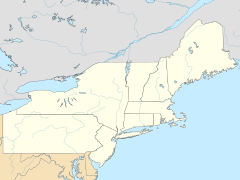
[edit]- Location maps for Mid-Atlantic states and Northeastern states (16 December)
-
Map of Mid-Atlantic states
-
Map of Northeast states
