User:ButuCC/Aerial photography
Jump to navigation
Jump to search

シーズン1
[edit]国土画像情報(カラー空中写真)を出典とする航空写真。
{{AerialPhotograph-mlitJP}}

|
The copyright holder of this file, the Ministry of Land, Infrastructure, Transport and Tourism of Japan, allows anyone to use it for any purpose, provided that the copyright holder is properly attributed. Redistribution, derivative work, commercial use, and all other use is permitted. |
Attribution:
Copyright © National Land Image Information (Color Aerial Photographs), Ministry of Land, Infrastructure, Transport and Tourism
|
 |
This image is copyrighted by the Ministry of Land, Infrastructure, Transport and Tourism of Japan. For terms of use, see the stipulation to use of National Land Information (in Japanese) and message from MLIT (in Japanese and English). When you display this image on an article, include the following phrase in the description: "Made based on National Land Image Information (Color Aerial Photographs), Ministry of Land, Infrastructure, Transport and Tourism".
|
-
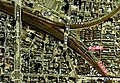
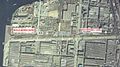
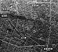
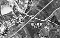
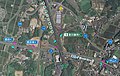
 金山駅・金山橋駅空中写真
(昭和52年度) -
 金山駅・金山橋駅空中写真
(昭和52年度) -

-
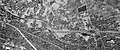
 鳴海工場空中写真
(昭和62年度) -
 尾張横須賀駅空中写真
(昭和52年度) -
 刈谷工場空中写真 (廃止後)
(昭和52年度) -
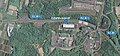
 刈谷駅南口空中写真
(昭和62年度) -
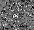
 中畑駅空中写真
(昭和62年度) -
 新須磨駅空中写真
(昭和52・57年度) -
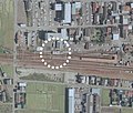
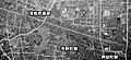
 八幡駅とその周辺施設
(昭和63年度) -
 豊山信号場空中写真
(昭和52・57年度) -
 小牧駅空中写真
(昭和52年度) -
 市ノ坪駅空中写真
(昭和50・57年度) -
 富田西口駅空中写真
(昭和50年度) -
 三岐朝明駅空中写真
(昭和50年度) -


シーズン2
[edit]地図・空中写真閲覧サービスを出典とする航空写真。
{{AerialPhotograph-gsi.go.jp}}
|
|
The copyright holder of this file, Ministry of Land, Infrastructure, Transport and Tourism, allows anyone to use it for any purpose, provided that the copyright holder is properly attributed. Redistribution, derivative work, commercial use, and all other use is permitted. |
Attribution:
National Land Image Information (Color Aerial Photographs), created by Ministry of Land, Infrastructure, Transport and Tourism, distributed by Geospatial Information Authority of Japan
|

2-1
[edit]-
 揖斐川駅
揖斐川駅
(1946年) -
 7号地
7号地
(1946年) -
 8号地
8号地
(1946年) -
 逗子線の「逗子」駅の変遷
(1946/1963/1983/1988) -
 谷津支線廃線跡
(1947年) -
 三河吉田駅
三河吉田駅
(1947年) -
 新鵜沼駅
新鵜沼駅
(1947年) -
 拾石・蒲郡競艇場前・
竹谷・塩津・江畑駅の変遷
(1947/1961/1977/2015) -
 塩浜駅
塩浜駅
(1947年) -
 入江崎駅
入江崎駅
(1948年) -
 桜本駅
桜本駅
(1948年) -
 廃止後の海神線
(1948年) -
 東古市駅
東古市駅
(1948年) -
 代田連絡線
代田連絡線
(1948年) -
 刈谷工場
刈谷工場
(昭和36年度) -
 安城支線
安城支線
(昭和36年度) -
 新川口支線
新川口支線
(1961年) -
 築港支線
築港支線
(1963年) -
 塩浜停留所
塩浜停留所
(1963年) -
 入江崎停留所
(1963年) -
 桜本停留所
桜本停留所
(1966年) -
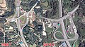
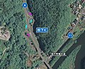
 番場PA
番場PA
(1969年) -
 名古屋港駅
名古屋港駅
(昭和50年度) -
 堀川口駅
堀川口駅
(昭和52年度) -
 白鳥駅
白鳥駅
(昭和52年度) -
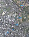
 名古屋市場駅
(昭和52年度) -
 東名古屋港駅
(昭和52年度) -
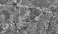
 三河Ωカーブ
(昭和52年度) -
 鷹来線路盤跡
(昭和52年度) -
 昭和町駅
昭和町駅
(1982年) -
 船見町駅
船見町駅
(1982年) -
 汐見町駅
汐見町駅
(1982年) -
 知多駅北側線
(1982年) -
 新可児駅
新可児駅
(昭和62年度) -
 新鵜沼駅
新鵜沼駅
(1987年) -
 新鵜沼駅
新鵜沼駅
(2008年)


2-2
[edit]-
 津島口駅
津島口駅
(1946年) -
 新居屋駅
新居屋駅
(1946年) -
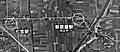
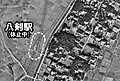 八剣駅
八剣駅
(1948年) -
 増田口駅
増田口駅
(1946年) -
 井戸口駅
井戸口駅
(1946年) -
 門間駅
門間駅
(1948年) -
 沖駅
沖駅
(1948年) -
 美濃石田駅
美濃石田駅
(1948年) -

-
 宮後駅
宮後駅
(1947年) -
 小折口駅
小折口駅
(1946年) -
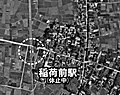 稲荷前駅
稲荷前駅
(1946年) -
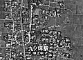 九ノ坪駅
九ノ坪駅
(1946年) -
 西宮後駅
西宮後駅
(1949年) -
 浦島駅
浦島駅
(1947年) -
 大足駅計画
大足駅計画
(1959年) -
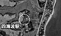 四海波駅
四海波駅
(1959年) -
 安良田駅
安良田駅
(1947年) -
 中市場駅
中市場駅
(1947年) -
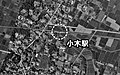 小木駅
小木駅
(1961年) -
 小針駅
小針駅
(1961年) -
 西小牧駅
西小牧駅
(1961年) -
 小牧駅
小牧駅
(1949年) -

-
 東富田駅
東富田駅
(1947年) -
 小幡駅
小幡駅
(1977年) -
小幡駅
(1987年) -
 三河平坂駅ほか
(1948年) -
 前波駅
前波駅
(1947年) -
 社宮祠駅
社宮祠駅
(1946年) -
 駅前駅ほか
駅前駅ほか
(1946年) -
 霞ヶ丘駅
霞ヶ丘駅
(1946年) -
 旭前駅
旭前駅
(1946年) -
 平池駅
平池駅
(1948年) -
 根ノ鼻駅
根ノ鼻駅
(1948年) -
 平野町駅
平野町駅
(1941年以前) -
 平野町駅
平野町駅
(1941年以前)


2-3
[edit]-
 知多半島道路
半田中央IC -
 知多半島道路
半田IC -
 南知多道路
南知多道路
武豊IC -
 南知多道路
南知多道路
美浜IC -
 南知多道路
南知多道路
南知多IC -
 猿投グリーンロード
八草IC -
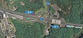 猿投グリーンロード
八草TB -
 猿投グリーンロード
猿投IC -
 猿投グリーンロード
西広瀬IC -
 猿投グリーンロード
枝下IC -
 衣浦豊田道路
生駒IC -
 衣浦豊田道路
牛田IC -
 衣浦豊田道路
新林IC -
 枇杷島橋駅
枇杷島橋駅
(1946) -
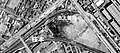
 枇杷島分岐点
(1977) -
 枇杷島分岐点
(1977) -
 枇杷島分岐点
(1946/63/87/07) -
 南方貨物線
南方貨物線
(1977) -
 寺田駅
寺田駅
(1961)


_Aerial_photography.gif)