Uploads by Homeruniverse~commonswiki
Jump to navigation
Jump to search
For Homeruniverse~commonswiki (talk · contributions · Move log · block log · uploads · Abuse filter log)
This special page shows all uploaded files that have not been deleted; for those see the upload log.
| Date | Name | Thumbnail | Size | Description |
|---|---|---|---|---|
| 16:51, 1 October 2005 | Vollziegel-Lochziegel-Wärmeweg.png (file) |  |
2 KB | Description: It shows the way the thermal goes throw a solid brick and throw a punched brick. Source: Free created with the GIMP. Date: 2005-10-01 Author: me. Permission: self-PD (Public Domain). Other versions of this file: no other Versions. |
| 19:37, 14 September 2005 | Basque Country location map.png (file) |  |
4 KB | Location map of the Basque Country (the Spain and the French part), multilingual |
| 16:43, 25 May 2005 | German Climate Oran.png (file) |  |
12 KB | Climate diagram (in German) of Oran in Algeria created with http://homeruniverse.xn--ngel-5qa.de/Programmieren/Klimadiagramm/Klimadiagramm.php {{PD}} Category:Climate diagrams Category:Algeria |
| 16:41, 25 May 2005 | German Climate Tebessa.png (file) |  |
12 KB | Climate diagram (in German) of Tebessa in Algeria created with http://homeruniverse.xn--ngel-5qa.de/Programmieren/Klimadiagramm/Klimadiagramm.php {{PD}} Category:Climate diagrams Category:Algeria |
| 16:41, 25 May 2005 | German Climate Tamanrasset.png (file) |  |
13 KB | Climate diagram (in German) of Tamanrasset in Algeria created with http://homeruniverse.xn--ngel-5qa.de/Programmieren/Klimadiagramm/Klimadiagramm.php {{PD}} Category:Climate diagrams Category:Algeria |
| 16:40, 25 May 2005 | German Climate Quarzazate.png (file) |  |
12 KB | Climate diagram (in German) of Quarzazate in Algeria created with http://homeruniverse.xn--ngel-5qa.de/Programmieren/Klimadiagramm/Klimadiagramm.php {{PD}} Category:Climate diagrams Category:Algeria |
| 16:38, 25 May 2005 | German Climate In Salah.png (file) |  |
12 KB | Climate diagram (in German) of In Salah in Algeria created with http://homeruniverse.xn--ngel-5qa.de/Programmieren/Klimadiagramm/Klimadiagramm.php {{PD}} Category:Climate diagrams Category:Algeria |
| 16:38, 25 May 2005 | German Climate In Amenas.png (file) |  |
12 KB | Climate diagram (in German) of In Amenas in Algeria created with http://homeruniverse.xn--ngel-5qa.de/Programmieren/Klimadiagramm/Klimadiagramm.php {{PD}} Category:Climate diagrams Category:Algeria |
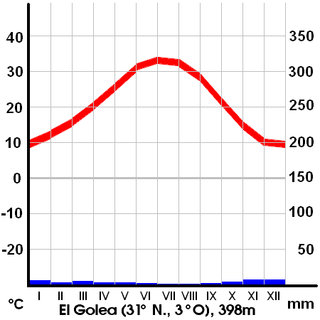
| 16:37, 25 May 2005 | German Climate El Golea.png (file) |  |
13 KB | Climate diagram (in German) of El Golea in Algeria created with http://homeruniverse.xn--ngel-5qa.de/Programmieren/Klimadiagramm/Klimadiagramm.php {{PD}} Category:Climate diagrams Category:Algeria |
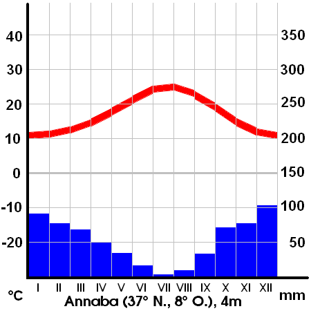
| 16:36, 25 May 2005 | German Climate Annaba.png (file) |  |
12 KB | Climate diagram (in German) of Annaba in Algeria created with http://homeruniverse.xn--ngel-5qa.de/Programmieren/Klimadiagramm/Klimadiagramm.php {{PD}} Category:Climate diagrams Category:Algeria |
| 21:07, 21 May 2005 | German Climate Stuttgart.png (file) |  |
12 KB | Climate diagram (in German) of Stuttgart in Germany created with http://homeruniverse.xn--ngel-5qa.de/Programmieren/Klimadiagramm/Klimadiagramm.php {{PD}} |
| 20:56, 21 May 2005 | German Climate Laghouat.png (file) |  |
12 KB | Climate diagram (in German) of Laghouat in Algeria created with http://homeruniverse.xn--ngel-5qa.de/Programmieren/Klimadiagramm/Klimadiagramm.php {{PD}} Category:Climate diagrams Category:Algeria |
| 20:52, 21 May 2005 | German Climate Addis Abeba.png (file) |  |
10 KB | Climate diagram (in German) of Addis Ababa in Ethiopia created with http://homeruniverse.xn--ngel-5qa.de/Programmieren/Klimadiagramm/Klimadiagramm.php {{PD}} |
| 00:00, 21 May 2005 | Addis Abeba.png (file) |  |
10 KB | Examplary climate diagram of Addis Ababa in Ethiopia created with http://homeruniverse.xn--ngel-5qa.de/Programmieren/Klimadiagramm/Klimadiagramm.php |
| 22:40, 17 May 2005 | Schotts and wadis explained2.jpg (file) |  |
115 KB | Das Bild zeigt zwei Fotos eines identischen Ausschnitts einiger Gebirgszüge in Marokko im Januar und im April. Die Karte zeigt die größten Flüße, ''Wadis'' und ''Schotts'' des Atlasgebirges. Die jährliche Schneeschmelze in den schneebedeckten Hochge |
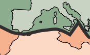
| 14:41, 16 May 2005 | Atlas Mountains tectonic plates.png (file) |  |
11 KB | see Image:Tectonic plates.png This is a section of the large image. {{PD-USGov-USGS}} |
| 00:03, 16 May 2005 | Schotts and wadis explained.jpg (file) |  |
76 KB | The picture shows some of Moroccos mountains in january and in april. It explains the ''wadis'' and ''schotts'' of the Atlas Mountains. I used two sources, both are {{PD}}. NASA satellite photo. {{PD-USGov-NASA}} Map created from [http://www2.demis.nl/ma |
| 22:17, 15 May 2005 | Marocco Mountains January April.jpg (file) |  |
35 KB | On Top there is a satellite photo showing a section of Atlas Mountains in January, on bottom it shows the same section in april NASA satellite photos. {{PD-USGov-NASA}} {{PD}} |
| 19:17, 15 May 2005 | Atlas Mountains over roofs of Marrakech.jpg (file) |  |
18 KB | original: http://de.wikipedia.org/wiki/Bild:Marrakesch_djemaa_el_fna_quessabine_moschee_neben_soukeingang.jpg * '''Description''': Quessabine Moschee, Platz Djemaa el Fna * '''Datum''': shoot 2000 * '''Fotograf''': Hans Peter Schaefer * '''Lizenz''': {{B |
| 15:24, 15 May 2005 | Atlasgebirge topografisch politsch.jpg (file) |  |
50 KB | Map created from [http://www2.demis.nl/mapserver/mapper.asp DEMIS Mapserver], which are public domain. I labeled the map (in German). {{PD}} |
| 13:44, 15 May 2005 | Africa Atlas Mountains.jpg (file) |  |
291 KB | NASA satellite photo. Self arranged. {{PD-USGov-NASA}} {{PD}} |
| 21:38, 13 May 2005 | Atlas Mountains.jpg (file) |  |
30 KB | I used a GP Sahara satellite photo from the NASA to create a map which brings out the Atlas Mountains. I hope it can be usefull to every article about the Atlas Mountains in every version of Wikipedia. |
| 19:28, 28 March 2005 | Faust, Teil1.pdf (file) |  |
427 KB | Johann Wolfgang von Goethe: Faust, 1. Teil von 1808, selbst eingelesen |